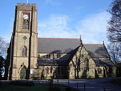
Adlington ist ein Dorf und eine Gemeinde im Borough of Chorley in Lancashire , England, nahe den West Pennine Moors . Es liegt 5 Kilometer südlich von Chorley .
ExzellentAdlington, Lancashire
Kategorie
6 Artikel
Adlington ist ein Dorf und eine Gemeinde im Borough of Chorley in Lancashire , England, nahe den West Pennine Moors . Es liegt 5 Kilometer südlich von Chorley .

Chorley ist eine Stadt und das Verwaltungszentrum des gleichnamigen Bezirks in Lancashire , England.

Coppull ist ein Dorf und eine Gemeinde in Lancashire , England. Es gehört zum Borough of Chorley und liegt etwa 91 Meter über dem Meeresspiegel.

Cuerden ist ein Dorf und eine Gemeinde im Borough of Chorley in Lancashire , England. Es liegt zwischen Bamber Bridge und Leyland und hatte im Jahr 2001 77 Einwohner.

Mawdesley ist ein Dorf und eine Gemeinde in Lancashire , England, die laut Volkszählung von 2011 1702 Einwohner zählte.

53°36′47″N 2°59′28″W / 53,613°N 2,991°W / 53.613; -2.991 Die West Lancashire Coastal Plain ist ein ausgedehntes Gebiet im Südwesten von Lancashire , England .