
Ardattin ( irisch : Ard Aitinn , bedeutet „ hoher Ginster “ ) ist ein Dorf und eine Ortschaft in der Grafschaft Carlow , Irland , 6 km südlich von Tullow .
GutIreland geography stubs
Kategorie
14 Artikel
Ardattin ( irisch : Ard Aitinn , bedeutet „ hoher Ginster “ ) ist ein Dorf und eine Ortschaft in der Grafschaft Carlow , Irland , 6 km südlich von Tullow .
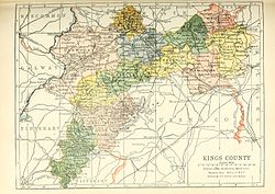
Ballycowan oder Ballycowen ( irisch : Baile Mhic Comhainn ) ist eine Baronie in der Grafschaft Offaly (ehemals King's County), Irland .
Ein Cantred war eine Unterteilung einer Grafschaft in der anglonormannischen Herrschaft Irlands zwischen dem 13. und 15. Jahrhundert, vergleichbar mit dem Cantref in Wales oder dem Hundred in England.

Castlebaldwin oder Bellanagarrigeeny ( irisch : Béal Átha na gCarraigíní , was „ Mündung der Furt der kleinen Felsen “ bedeutet ) ist ein Townland und ein kleines Dorf in der Grafschaft Sligo , Irland .

Der Fluss Fane ( irisch : Abhainn Átha Féan ) ist ein Fluss, der von der Grafschaft Monaghan zur Dundalk Bay in der Grafschaft Louth , Irland , fließt .
Geological Survey Ireland oder Geological Survey of Ireland ( irisch : Suirbhéireacht Gheolaíochta Éireann ), gegründet 1845, ist die nationale Erdwissenschaftsbehörde Irlands . Der Hauptsitz befindet sich in Dublin .

Glaslough ( / ɡlæsˈlɒx / glas - LOKH ; Irisch : Glasloch , bedeutet „ grüner See “ ) ist ein Dorf und eine Ortschaft im Norden der Grafschaft Monaghan in Irland , an der Regionalstraße R185 , 3 km südlich der Grenze zu

Die Kiltera Ogham Stones sind zwei Oghamsteine , die ein Nationaldenkmal in der Grafschaft Waterford , Irland, bilden .
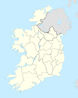
Lough Cullen ( irisch : Loch Cuilinn , was „Stechpalmensee“ bedeutet ) ist der einzige See in der Grafschaft Kilkenny , Irland . Um den See ranken sich zahlreiche Legenden.

Oram ( irisch : Eoroim , was „Eibenhügel“ bedeutet) ist ein Dorf und eine Ortschaft in der Grafschaft Monaghan , Irland. Das Dorf liegt an der Straße R182 , etwa 5 Kilometer nordöstlich von Castleblayney .

Rathcoole is a parish in County Kilkenny. It does not give its name to any townland, but the first church there is believed to have been Teampall Ráth chúil. The parish consists of the following towlands:

Rosenallis (historisch Rossinallis , aus dem Irischen : Ros Fhionnghlaise , was „Wald des klaren Baches“ bedeutet) ist ein Dorf im Norden der Grafschaft Laois in Irland .

Sandfordscourt (früher „Cantwell’s Court“) ist ein Ortsteil (Townland) in der Gemeinde Rathcoole innerhalb der historischen Baronie Gowran , County Kilkenny , Irland.
Tulla ist eine Pfarrei in der Grafschaft Clare , Irland, und gehört zur Pfarrgruppe Ceantar na Lochanna innerhalb der römisch-katholischen Diözese Killaloe .