Die Liste der Inseln im Murray River in Südaustralien ist eine Liste der Inseln, die sich im Wasserlauf des Murray River im australischen Bundesstaat Südaustralien befinden , von der Mündung des Flusses bei Encounter Bay im Süden bis zu den Grenzen zu den Bundesstaaten New South Wales und Victoria im Osten, einschließlich der folgenden Seen, die sich in der Nähe der Flussmündung befinden - Coorong , Lake Albert und Lake Alexandrina .
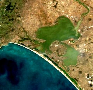
Coorong
Die folgende Liste umfasst die Inseln (von West nach Ost) im Coorong sowie die beiden Kanäle, die ihn mit Port Pullen an der Murray-Mündung verbinden : den Coorong-Kanal und den Tauwitchere-Kanal. Stand 2014 befanden sich alle in der folgenden Liste aufgeführten Inseln innerhalb der Grenzen des Coorong-Nationalparks . [ 1 ] [ 2 ] [ 3 ] [ 4 ] [ 5 ] [ 6 ]
Albertsee
| Name | Koordinaten | Anmerkungen |
|---|---|---|
| Bascombe Island | 35°43′35″S 139°15′49″E / 35.72648039°S 139.26348163°E | Die Insel befindet sich in einer Bucht am südlichen Ende des Sees, die auch als Bascombe Bay bekannt ist [ 2 ] [ 7 ] [ 28 ]. |
Lake Alexandrina
Nachfolgend eine Liste der Inseln (von West nach Ost) im Alexandrinasee einschließlich der Inselgruppe am südlichen Ende des Sees. [ 6 ]
| Name | Koordinaten | Anmerkungen |
|---|---|---|
| Goose Island | 35°29′30″S 138°49′53″E / 35.49172152°S 138.83152770°E | Eine Insel, die durch den in den 1930er Jahren durch den Bau der Staudämme verursachten Anstieg des Meeresspiegels überflutet wurde. Sie liegt innerhalb der Grenzen des Currency Creek Wildreservats. [ 29 ] |
| Billygoat-Inseln | 35°29′18″S 138°50′11″E / 35.48844308°S 138.83643637°E | Es soll sich um eine Gruppe kleiner Inseln handeln, von denen viele durch den Anstieg des Flusspegels infolge des Baus von Staudämmen in den 1930er Jahren überflutet wurden. Sie liegt innerhalb der Grenzen des Currency Creek Wildreservats . [ 30 ] |
| Schilfinsel | 35°31′53″S 138°50′39″E / 35.531270°S 138.844230°E | Die Insel befindet sich im Goolwa-Kanal südlich von Hindmarsh Island innerhalb der Grenzen des Coorong-Nationalparks. [ 1 ] [ 31 ] |
| Rushy Island | 35°32′08″S 138°50′59″E / 35.535440°S 138.849680°E | Die Insel befindet sich im Goolwa-Kanal südlich von Hindmarsh Island innerhalb der Grenzen des Coorong-Nationalparks. [ 1 ] [ 32 ] |
| Hindmarsh-Insel | 35°30′58″S 138°52′34″E / 35.51618332°S 138.87616566°E | [ 1 ] [ 2 ] [ 33 ] |
| Vogelinsel | 35°33′10″S 138°53′44″E / 35.55288311°S 138.89542664°E | Die Insel liegt im Coorong-Kanal südlich von Hindmarsh Island innerhalb des Coorong-Nationalparks. Sie ist auch als Gull Island bekannt. [ 1 ] [ 2 ] [ 34 ] |
| Varcoe-Insel | 35°32′31″S 138°54′04″E / 35.541960°S 138.901010°E | Insel im Mundoo-Kanal zwischen Hindmarsh und Mundoo Islands., [ 1 ] [ 35 ] |
| Luzerner Insel | 35°31′54″S 138°55′31″E / 35.53156940°S 138.92519926°E | [ 1 ] [ 4 ] [ 36 ] |
| Mundoo-Insel | 35°32′47″S 138°56′02″E / 35.546510°S 138.9339°E | [ 1 ] [ 2 ] [ 37 ] |
| Goose Island | 35°30′05″S 138°56′09″E / 35.50127164°S 138.93570995°E | Insel östlich der Stadt Clayton Bay . [ 1 ] [ 38 ] |
| Ziegeninsel | 35°30′15″S 138°56′37″E / 35.504110°S 138.943560°E | Insel östlich der Stadt Clayton Bay. [ 1 ] [ 39 ] |
| Ewe-Insel | 35°33′23″S 138°56′49″E / 35.556260°S 138.947020°E | Laut einem 1877 veröffentlichten Atlas wurden sie und Long Island als eine einzige Insel namens Reedy Island betrachtet. [ 1 ] [ 2 ] [ 40 ] [ 41 ] |
| Ratteninsel | 35°31′13″S 138°57′33″E / 35.520140°S 138.959110°E | Auch Ram Island genannt. [ 1 ] [ 42 ] [ 43 ] |
| Long Island | 35°32′15″S 138°59′06″E / 35.537480°S 138.98487346°E | Sie ist auch unter den Namen Ram Island und Grindstone Island bekannt. Laut einem 1877 veröffentlichten Atlas wurden sie und Ewe Island als eine einzige Insel namens Reedy Island betrachtet. [ 1 ] [ 2 ] [ 44 ] [ 41 ] |
| Tauwitchere-Insel | 35°34′28″S 138°59′22″E / 35.574560°S 138.989540°E | Die Insel wird auch unter den Namen Towagery, Towatchery und Talwadjeri Island geführt und soll eine Fläche von 144 Hektar (356 Acres) haben. [ 45 ] [ 46 ] |
| Myrtle Island | 35°34′08″S 138°59′32″E / 35.5689°S 138.992280°E | Insel innerhalb des Mud Islands Wildreservats . [ 47 ] [ 48 ] |
| Schlangeninsel | 35°33′41″S 138°59′49″E / 35.56143004°S 138.99698025°E | [ 3 ] [ 49 ] [ 46 ] |
| Schlamminsel | 35°33′51″S 139°00′43″E / 35.564130°S 139.011910°E | Island reported as having an area of 17 hectares (43 acres). It lies within the boundaries of the Mud Island Game Reserve.[50] |
| Reedy Island No 2 | 35°33′22″S139°00′43″E / 35.5560°S 139.012070°E | [4][46][51] |
| Pomanda Island | 35°24′58″S139°18′29″E / 35.41600826°S 139.30799221°E | Island located adjacent of the channel of the Murray River immediately south of its entry into Lake Alexandrina.[52][53] |
 |  |  |
Wellington to Morgan
The following is a list of islands (from south to north) within the river’s channel between the town of Wellington and the town of Morgan.
| Name | Coordinates | Remarks |
|---|---|---|
| Miss Gawler Island | 35°08′50″S139°18′35″E / 35.14728707°S 139.30978°E | Island located south east of the city of Murray Bridge and is located beneath the Swanport Bridge.[54][55] |
| Long Island | 35°07′48″S139°17′59″E / 35.130070°S 139.299730°E | The island located immediately opposite Murray Bridge and is within the boundaries of the Long Island Recreation Park. The island is considered by the Ngarrindjeri, the Australian Aboriginal people associated with the locality, to be “highly sensitive” (i.e. “high cultural and/or (sic) heritage importance”).[54][56][57] |
| Nott Island | 34°22′44″S139°37′30″E / 34.37875552°S 139.62503174°E | Island located about 3 kilometres (1.9 miles) south of the town of Blanchetown.[58][59] |
| Reedy Island | 34°17′43″S139°38′12″E / 34.29535698°S 139.63662083°E | Island located about 7 kilometres (4.3 miles) north of Blanchetown, immediately across the river from the Roonka Conservation Park and immediately south of Julia Island.[60][61] |
| Julia Island | 34°17′30″S139°38′24″E / 34.291560°S 139.639870°E | Island located immediately adjacent to Reedy Island and across the river from the Roonka Conservation Park.[60][62] |
 |  |  |
Morgan to the border
The following is a list of islands (from west to east) within the river’s channel between the town of Morgan and the borders with New South Wales and Victoria.
| Name | Coordinates | Remarks |
|---|---|---|
| Hart Island | 34°10′33″S140°03′17″E / 34.17590386°S 140.05461270°E | Island located east of the town of Waikerie. Previously known as Wigleys Island. The current name has been in use since at least 1888, possibly named after J.Hart, a pastoralist.[63][64] |
| Sandy Island | 34°10′57″S140°05′04″E / 34.182510°S 140.084360°E | The existence of this island is based on an entry in an atlas dated 1877. As of 2015, the responsible government agency reported that the island is not indicated on "current mapping" within the locality.[65] |
| Ball Island | 34°10′59″S140°20′27″E / 34.183180°S 140.340790°E | [66] |
| Thurk Island | 34°13′05″S140°22′02″E / 34.21804118°S 140.36710836°E | Island located in the channel east of Kingston-on-Murray opposite the Loch Luna Game Reserve. Previously known as Chambers Island or Isle.[67][68] |
| Moorook Island | 34°17′13″S140°22′12″E / 34.28693766°S 140.36996279°E | Island located opposite to the town of Moorook. Also known as Moorook Isle and Moorik Isle.[67][69] |
| Nynes Island | 34°19′58″S140°23′11″E / 34.33285356°S 140.38643302°E | Previously known as Pyap Island.[70][71] |
| Forbys Island | 34°26′36″S140°30′00″E / 34.44320925°S 140.50006195°E | [72][73] |
| Katarapko Island | 34°24′20″S140°33′22″E / 34.40566248°S 140.55608657°E | Island is located within the extent of the Murray River National Park. Previously known as Cragg Island.[74][75][76] |
| Kapunda Island | 34°26′54″S140°33′36″E / 34.44846740°S 140.55998258°E | Located in the main river channel to the immediate north-west of Loxton and within the Kapunda Island Conservation Park. In 1994, the island was reported as having an area of 1 hectare (2.5 acres) and as being “only accessible by boat.”[75][77][78][79] |
| Rilli Island | 34°23′37″S140°34′40″E / 34.39356053°S 140.57769733°E | Die Insel liegt innerhalb des Rilli Island Conservation Park . Sie war früher als Riley Island und auch als Rilli Isle bekannt. 1994 hatte die Insel eine Fläche von 4 Hektar (9,9 Acres) und war „nur mit dem Boot erreichbar, außer bei Niedrigwasser, dann ist sie zu Fuß vom Südufer des Flusses aus zugänglich…“ [ 75 ] [ 80 ] [ 81 ] [ 79 ] |
| Medieninsel | 34°25′46″S 140°35′17″E / 34.429540°S 140.588180°E | Die Insel liegt südöstlich von Loxton und gehört zum Media Island Conservation Park . Sie war früher als Medea Island und auch als Media Isle bekannt. 1994 wurde die Fläche der Insel mit 1 Hektar (2,5 Acres) angegeben. Sie sei „nur mit dem Boot erreichbar, außer bei Niedrigwasser, dann ist sie zu Fuß vom Südufer des Flusses aus zugänglich…“ [ 75 ] [ 82 ] [ 83 ] [ 79 ] |
| Punkey Island | 34°15′15″S 140°42′24″E / 34.25412471°S 140.70654564°E | Auch bekannt als Penky Island. [ 84 ] [ 85 ] |
| Cemnell-Insel | 34°14′20″S 140°42′27″E / 34.238870°S 140.707420°E | Auch bekannt als Gumnell Island. [ 84 ] [ 86 ] |
| Muklemuk-Insel | 34°14′11″S 140°43′52″E / 34.236460°S 140.731150°E | Auch bekannt als Muckle Muk Island. [ 84 ] [ 87 ] |
| Reny Island | 34°03′33″S 140°44′09″E / 34.05910722°S 140.73577007°E | [ 88 ] [ 89 ] [ 90 ] |
| Nelbuck-Insel | 34°06′05″S 140°44′47″E / 34.10144157°S 140.74633239°E | Die an die Insel Bulyong angrenzende Insel wurde am 19. September 1996 auf Anweisung des Umweltministers des Bundesstaates im Amtsblatt veröffentlicht. |
| Nelwart Island | 34°12′55″S 140°44′56″E / 34.215280°S 140.749°E | Auch Nelwart Island genannt [ 80 ] [ 92 ] |
| Ziegeninsel | 34°11′14″S 140°45′08″E / 34.18720150°S 140.75220533°E | [ 93 ] [ 94 ] |
| Bulyong-Insel | 34°07′21″S 140°45′51″E / 34.122540°S 140.764160°E | Die Insel liegt innerhalb des Murray River Nationalparks. [ 88 ] [ 95 ] [ 96 ] |
| Kylie Island | 34°08′12″S 140°45′51″E / 34.13679281°S 140.76420893°E | Der Name leitet sich vom Familiennamen der Landbesitzer ab. [ 97 ] |
| Causeway Island | 34°10′08″S 140°45′56″E / 34.168880°S 140.765420°E | [ 84 ] [ 98 ] |
| Longwang-Insel | 34°08′53″S 140°46′15″E / 34.14815204°S 140.77084040°E | [ 99 ] [ 88 ] [ 100 ] |
| Sandy Island | 34°15′20″S 140°47′34″E / 34.255650°S 140.7927°E | Auch bekannt als Sandy Ridge. [ 101 ] |
| Hunchee-Insel | 34°03′07″S 140°47′36″E / 34.051840°S 140.7933°E | [ 102 ] [ 103 ] |
| Little Hunchee Island | 34°01′57″S 140°49′28″E / 34.03257899°S 140.82436519°E | Die Insel liegt teilweise innerhalb des Chowilla-Wildreservats . [ 102 ] [ 103 ] [ 104 ] |
| Chowilla-Insel | 33°59′19″S 140°52′44″E / 33.98870183°S 140.87895483°E | Insel innerhalb des Chowilla-Wildreservats. [ 105 ] [ 106 ] [ 107 ] |
| Monoman-Insel | 33°59′19″S 140°52′44″E / 33.98870183°S 140.87895483°E | Insel innerhalb des Chowilla-Wildreservats. [ 106 ] [ 108 ] [ 109 ] |
| Schilfinsel | 33°57′51″S 140°54′15″E / 33.964280°S 140.9043°E | Insel innerhalb des Chowilla-Wildreservats. [ 110 ] [ 111 ] |
| Boat Creek Island | 33°57′09″S 140°54′45″E / 33.952530°S 140.912580°E | Insel innerhalb des Chowilla-Wildreservats. [ 106 ] [ 110 ] [ 112 ] |
| Slaney Island | 33°57′00″S 140°55′51″E / 33.949990°S 140.930850°E | Insel innerhalb des Chowilla-Wildreservats. Auch bekannt als Stanley Island. [ 106 ] [ 113 ] [ 114 ] |
| Newena Island | 33°57′44″S 140°55′55″E / 33.96218883°S 140.93196606°E | Insel innerhalb des Chowilla-Wildreservats; auch bekannt als Isle of Man. [ 113 ] [ 115 ] |
| Punkah Island | 33°56′45″S 140°58′04″E / 33.945940°S 140.967860°E | Insel innerhalb des Chowilla-Wildreservats. [ 113 ] [ 116 ] |
| Wilpena-Insel | 33°59′50″S 140°59′00″E / 33.99718402°S 140.98329388°E | Insel innerhalb des Chowilla-Wildreservats. [ 106 ] [ 117 ] [ 118 ] |
| Grand Junction Island | 33°58′50″S 140°59′22″E / 33.980640°S 140.989340°E | Insel innerhalb des Chowilla-Wildreservats. [ 106 ] [ 119 ] [ 120 ] |
| Hypurna-Insel | 34°00′12″S 140°59′57″E / 34.00344271°S 140.99915737°E | Die Insel, die teilweise im Chowilla-Wildreservat liegt, erstreckt sich auch über die Grenze zu New South Wales. [ 106 ] [ 121 ] [ 122 ] |
 |  |  |
Siehe auch
Zitate und Referenzen
Zitate
- ^ a b c d e f g h i j k l m BIA, 2005, Seite 27
- ^ a b c d e f g DEWNR, 2014a
- ^ a b c d e f g h DEWNR, 2014b
- ^ a b c d e f g h i j k l m n o p DEWNR , 2014c
- ^ a b DEWNR, 2014d
- ^ a b DMH, 1985, Diagramm 9
- ^ a b BIA, 2005, Seite 31
- ^ DPTI, Suchergebnis für Sam Island (Datensatz-Nr. SA0035074), 2015
- ^ DPTI, Suchergebnis für Needles Island (Datensatz-Nr. SA0034856), 2015
- ^ DPTI, Suchergebnis für Goat Island (Datensatz-Nr. SA0026789), 2015
- ^ DPTI, Suchergebnis für Snake Island (Datensatz-Nr. SA0035115), 2015
- ^ DPTI, Suchergebnis für Rabbit Island (Datensatz-Nr. SA0034979), 2015
- ^ DPTI, Suchergebnis für Bluff Island (Datensatz-Nr. SA0007754), 2015
- ^ DPTI, Suchergebnis für Bull Island (Datensatz-Nr. SA0056805), 2015
- ^ DPTI, Suchergebnis für Cow Island (Datensatz-Nr. SA0016523), 2015
- ^ DPTI, Suchergebnis für Long Island (Datensatz-Nr. SA0033818), 2015
- ^ DPTI, Suchergebnis für Round Island (Datensatz-Nr. SA0035054), 2015
- ^ DPTI, Suchergebnis für Swan Island (Datensatz-Nr. SA0014524), 2015
- ^ DPTI, Suchergebnis für Stony Well Island (Datensatz-Nr. SA0014525), 2015
- ^ DPTI, Suchergebnis für Cattle Island (Datensatznr. SA0012910), 2015
- ^ DPTI, Suchergebnis für Teal Island (Datensatz-Nr. SA0035196), 2015
- ^ DPTI, Suchergebnis für North Pelican Island (Datensatz-Nr. SA0034870), 2015
- ^ DPTI, Suchergebnis für Halfway Island (Datensatz-Nr. SA0028944), 2015
- ^ DPTI, Suchergebnis für Pelican Island (Datensatz-Nr. SA0034917), 2015
- ^ DPTI, Suchergebnis für Mellor Island (Datensatz-Nr. SA0034750), 2015
- ^ DPTI, Suchergebnis für Seagull Island (Datensatz-Nr. SA0035084), 2015
- ^ DPTI, Suchergebnis für Wild Dog Island (Datensatz-Nr. SA0035332), 2015
- ^ DPTI, Suchergebnis für Bascombe Island (Datensatz-Nr. SA0005074), 2015
- ^ DPTI, Suchergebnis für Goose Island (Datensatz-Nr. SA0004115), 2015
- ^ DPTI, Suchergebnis für Billygoat Islands (Datensatz-Nr. SA0004116), 2015
- ^ DPTI, Suchergebnis für Reedy Island (Datensatz-Nr. SA0037142), 2015
- ^ DPTI, Suchergebnis für Rushy Island (Datensatz-Nr. SA0059654), 2015
- ^ DPTI, Suchergebnis für Hindmarsh Island (Datensatz-Nr. SA0030657), 2015
- ^ DPTI, Suchergebnis für Bird Island (Datensatz-Nr. SA0006607), 2015
- ^ DPTI, Suchergebnis für Varcoe Island (Datensatz-Nr. SA0012909), 2015
- ^ DPTI, Suchergebnis für Insel Luzern (Datensatz-Nr. SA0041615), 2015
- ^ DPTI, Suchergebnis für Mundoo Island (Datensatz-Nr. SA0047690), 2015
- ^ DPTI, Suchergebnis für Goose Island (Datensatz-Nr. SA0027022), 2015
- ^ DPTI, Suchergebnis für Goat Island (Datensatz-Nr. SA0026791), 2015
- ^ DPTI, Suchergebnis für Ewe Island (Datensatz-Nr. SA0023158), 2015
- ^ a b DPTI, Suchergebnis für Reedy Island (Datensatznr. SA0034994), 2015
- ^ DPTI, Suchergebnis für Rat Island (Datensatz-Nr. SA0057873), 2015
- ^ DPTI, Suchergebnis für Grindstone Island (Datensatz-Nr. SA0003913), 2015
- ^ DPTI, Suchergebnis für Long Island (Datensatz-Nr. SA0033820), 2015
- ^ DPTI, Suchergebnis für Tauwitchere Island (Datensatz-Nr. SA0035193), 2015
- ^ a b c BIA, 2005, Seite 30
- ^ DPTI, Suchergebnis für Myrtle Island (Datensatznr. SA0034839), 2015
- ^ BIA, 2005, Seite 38
- ^ DPTI, Suchergebnis für Snake Island (Datensatz-Nr. SA0035116), 2015
- ^ DPTI, Suchergebnis für Mud Island (Datensatz-Nr. SA0034820), 2015
- ^ DPTI, Suchergebnis für Reedy Island Nr. 2 (Datensatz-Nr. SA0034995), 2015
- ^ DPTI, Suchergebnis für Pomanda Island (Datensatz-Nr. SA0056221), 2015
- ^ BIA, 2005, Seite 29
- ^ a b BIA, 2005, Seite 61
- ^ DPTI, Suchergebnis für Long Island (Datensatz-Nr. SA0040326), 2015
- ^ DPTI, Suchergebnis für Long Island (Datensatz-Nr. SA0041196), 2015
- ^ „Kungun Ngarrindjeri Yunnan-Abkommen“ (PDF) . Die ländliche Stadt Murray Bridge. S. 9 & 11 . Abgerufen am 25. August 2015 .
- ^ BIA, 2005, Seite 95
- ^ DPTI, Suchergebnis für Nott Island (Datensatz-Nr. SA0051023), 2015
- ^ a b BIA, 2005, Seiten 95-96
- ^ DPTI, Suchergebnis für Reedy Island (Datensatz-Nr. SA0058334), 2015
- ^ DPTI, Suchergebnis für Julia Island (Datensatz-Nr. SA0033236), 2015
- ^ BIA, 2005, Seiten 114-115
- ^ DPTI, Suchergebnis für Hart Island (Datensatz-Nr. SA0029494), 2015
- ^ DPTI, Suchergebnis für Sandy Island (Datensatz-Nr. SA0059785), 2015
- ^ DPTI, Suchergebnis für Ball Island (Datensatz-Nr. SA0004351), 2015
- ^ a b BIA, 2005, Seite 123
- ^ DPTI, Suchergebnis für Thurk Island (Datensatz-Nr. SA0066369), 2015
- ^ DPTI, Suchergebnis für Moorook Island (Datensatznummer SA0023380), 2015
- ^ BIA, 2005, Seite 126
- ^ DPTI, Suchergebnis für Nynes Island (Datensatz-Nr. SA0051375), 2015
- ^ BIA, 2005, Seite 130
- ^ DPTI, Suchergebnis für Forbys Island (Datensatz-Nr. SA0024536), 2015
- ^ BIA, 2005, Seite 131
- ^ a b c d DENR, 1994, Seiten 7-8
- ^ DPTI, Suchergebnis für Kataropko Island (Datensatznummer SA0023380), 2015
- ^ BIA, 2005, Seite 132
- ^ DPTI, Suchergebnis für Kapunda Island (Datensatz-Nr. SA0034114), 2015
- ^ a b c DENR, 1994, Seite vi
- ^ a b BIA, 2005, Seiten 133 & 134
- ^ DPTI, Suchergebnis für Rilli Island (Datensatz-Nr. SA0058510), 2015
- ^ BIA, 2005, Seite 133
- ^ DPTI, Suchergebnis für Media Island (Datensatznummer SA0044069), 2015
- ^ a b c d BIA, 2005, Seite 140
- ^ DPTI, Suchergebnis für Punkey Island (Datensatznr. SA0054339), 2015
- ^ DPTI, Suchergebnis für Cumlell Island (Datensatz-Nr. SA0017257), 2015
- ^ DPTI, Suchergebnis für Muklemuk Island (Datensatz-Nr. SA0047406), 2015
- ^ a b c DENR, 1994, Seiten 69-70
- ^ BIA, 2005, Seite 145
- ^ DPTI, Suchergebnis für Reny Island (Datensatz-Nr. SA0040854), 2015
- ^ DPTI, Suchergebnis für Nelbuck Island (Datensatz-Nr. SA0003793), 2015
- ^ DPTI, Suchergebnis für Nelwort Island (Datensatz-Nr. SA0049149), 2015
- ^ BIA, 2005, Seite 142
- ^ DPTI, Suchergebnis für Goat Island (Datensatz-Nr. SA0026784), 2015
- ^ BIA, 2005, Seite 144
- ^ DPTI, Suchergebnis für Bulyong Island (Datensatz-Nr. SA0010696), 2015
- ^ DPTI, Suchergebnis für Kylie Island (Datensatznr. SA0003796), 2015
- ^ DPTI, Suchergebnis für Causeway Island (Datensatz-Nr. SA0012937), 2015
- ^ BIA, 2005, Seite 143
- ^ DPTI, Suchergebnis für Longwang Island (Datensatz-Nr. SA0040047), 2015
- ^ DPTI, Suchergebnis für Sandy Island (Datensatz-Nr. SA0059784), 2015
- ^ a b BIA, 2005, Seite 146
- ^ a b DPTI, Suchergebnis für Hunchee Island (Datensatz-Nr. SA0031527), 2015
- ^ DPTI, Suchergebnis für Little Hunchee Island (Datensatz-Nr. SA0040020), 2015
- ^ BIA, 2005, Seiten 148-149
- ^ a b c d e f g DEWNR, 2014e
- ^ DPTI, Suchergebnis für Chowilla Island (Datensatz-Nr. SA0007424), 2015
- ^ DEWNR, 2014
- ^ DPTI, Suchergebnis für Monoman Island (Datensatz-Nr. SA0045650), 2015
- ^ a b BIA, 2005, Seite 150
- ^ DPTI, Suchergebnis für Reedy Island (Datensatz-Nr. SA0035000), 2015
- ^ DPTI, Suchergebnis für Boat Creek Island (Datensatz-Nr. SA0007887), 2015
- ^ a b c BIA, 2005, Seite 151
- ^ DPTI, Suchergebnis für Slaney Island (Datensatz-Nr. SA0061931), 2015
- ^ DPTI, Suchergebnis für Newena Island (Datensatz-Nr. SA0044012), 2015
- ^ DPTI, Suchergebnis für Punkah Island (Datensatz-Nr. SA0057088), 2015
- ^ BIA, 2005, Seiten 152-153
- ^ DPTI, Suchergebnis für Wilperna Island (Datensatz-Nr. SA0022294), 2015
- ^ BIA, 2005, Seite 152
- ^ DPTI, Suchergebnis für Grand Junction Island (Datensatz-Nr. SA0027353), 2015
- ^ BIA, 2005, Seite 153
- ^ DPTI, Suchergebnis für Hypurna Island (Datensatz-Nr. SA0031703), 2015
Referenzen
- Verband der Bootsindustrie von Südaustralien (BIA); Ministerium für Umwelt und Kulturerbe von Südaustralien (2005), Südaustraliens Gewässer: Ein Atlas und Führer , Verband der Bootsindustrie von Südaustralien, ISBN 978-1-86254-680-6
- „Managementplan für den Murray River Nationalpark (einschließlich Rilli Island, Media Island und Kapunda Island Conservation Park)“ (PDF) . Ministerium für Umwelt und natürliche Ressourcen (DENR). 1994. Archiviert vom Original (PDF) am 24. September 2015. Abgerufen am 16. Januar 2015 .
- „Coorong-Nationalpark – Karte von der Goolwa-Staumauer bis Long Point“ (PDF) . Ministerium für Umwelt, Wasser und natürliche Ressourcen (DEWNR). 2014a . Abgerufen am 29. Juli 2015 .
- „Coorong Nationalpark – Karte von Long Point nach Magrath Flat“ (PDF) . Ministerium für Umwelt, Wasser und natürliche Ressourcen (DEWNR). 2014b . Abgerufen am 29. Juli 2015 .
- „Coorong Nationalpark – Karte von Magrath Flat nach Policeman Point“ (PDF) . Ministerium für Umwelt, Wasser und natürliche Ressourcen (DEWNR). 2014c . Abgerufen am 29. Juli 2015 .
- „Coorong-Nationalpark – Karte von Policeman Point bis 42 Mile Crossing“ (PDF) . Ministerium für Umwelt, Wasser und natürliche Ressourcen (DEWNR). 2014d . Abgerufen am 29. Juli 2015 .
- „Chowilla-Wildreservat – Karte der vorübergehenden Schließungen“ (PDF) . Ministerium für Umwelt, Wasser und natürliche Ressourcen. 2014e . Abgerufen am 17. August 2015 .
- Südaustralien. Ministerium für Schifffahrt und Häfen (DMH) (1985), Die Gewässer Südaustraliens: Eine Reihe von Seekarten, Segelhinweisen und Küstenfotografien , Ministerium für Schifffahrt und Häfen, Südaustralien, ISBN 978-0-7243-7603-2
- „Immobilienstandort-Browser“ . Ministerium für Planung, Verkehr und Infrastruktur (DPTI). 2015. Archiviert vom Original am 12. Oktober 2016. Abgerufen am 15. August 2015 .

