In geology, a supercontinent is the assembly of most or all of Earth's continental blocks or cratons to form a single large landmass.[1][2][3] However, some geologists use a different definition, "a grouping of formerly dispersed continents", which leaves room for interpretation and is easier to apply to Precambrian times.[4] To separate supercontinents from other groupings, a limit has been proposed in which a continent must include at least about 75% of the continental crust then in existence in order to qualify as a supercontinent.[5]
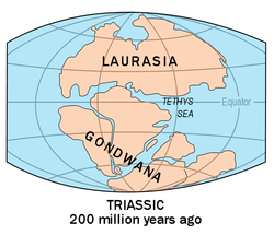
Moving under the forces of plate tectonics, supercontinents have assembled and dispersed multiple times in the geologic past. According to modern definitions, a supercontinent does not exist today;[1] the closest is the current Afro-Eurasian landmass, which covers approximately 57% of Earth's total land area. The last period in which the continental landmasses were near to one another was 336 to 175 million years ago, forming the supercontinent Pangaea. The positions of continents have been accurately determined back to the early Jurassic, shortly before the breakup of Pangaea.[6] Pangaea's predecessor Gondwana is not considered a supercontinent under the first definition since the landmasses of Baltica, Laurentia and Siberia were separate at the time.[7]
A future supercontinent, termed Pangaea Proxima, is hypothesized to form within the next 250 million years.[8]
Theories
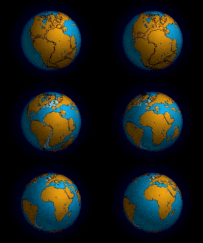
The Phanerozoic supercontinent Pangaea began to break up 215 Ma and this distancing continues today. Because Pangaea is the most recent of Earth's supercontinents, it is the best known and understood. Contributing to Pangaea's popularity in the classroom, its reconstruction is almost as simple as fitting together the present continents bordering the Atlantic ocean like puzzle pieces.[4]
For the period before Pangaea, there are two contrasting models for supercontinent evolution through geological time.
Series
The first model theorizes that at least two separate supercontinents existed comprising Vaalbara and Kenorland, with Kenorland comprising Superia and Sclavia. These parts of Neoarchean age broke off at ~2480 and 2312 Ma, and portions of them later collided to form Nuna (Northern Europe and North America). Nuna continued to develop during the Mesoproterozoic, primarily by lateral accretion of juvenile arcs, and in ~1000 Ma Nuna collided with other land masses, forming Rodinia.[4] Between ~825 and 750 Ma Rodinia broke apart.[9] However, before completely breaking up, some fragments of Rodinia had already come together to form Gondwana by ~608 Ma. Pangaea formed through the collision of Gondwana, Laurasia (Laurentia and Baltica), and Siberia.
Protopangea–Paleopangea
The second model (Kenorland-Arctica) is based on both palaeomagnetic and geological evidence and proposes that the continental crust comprised a single supercontinent from ~2.72 Ga until break-up during the Ediacaran period after ~0.573 Ga. The reconstruction[10] is derived from the observation that palaeomagnetic poles converge to quasi-static positions for long intervals between ~2.72–2.115 Ga; 1.35–1.13 Ga; and 0.75–0.573 Ga with only small peripheral modifications to the reconstruction.[11] During the intervening periods, the poles conform to a unified apparent polar wander path.
Although it contrasts the first model, the first phase (Protopangea) essentially incorporates Vaalbara and Kenorland of the first model. The explanation for the prolonged duration of the Protopangea–Paleopangea supercontinent appears to be that lid tectonics (comparable to the tectonics operating on Mars and Venus) prevailed during Precambrian times. According to this theory, plate tectonics as seen on the contemporary Earth became dominant only during the latter part of geological times.[11] This approach was widely criticized by many researchers as it uses incorrect application of paleomagnetic data.[12]
Cycles
A supercontinent cycle is the break-up of one supercontinent and the development of another, which takes place on a global scale.[4] Supercontinent cycles are not the same as the Wilson cycle, which is the opening and closing of an individual oceanic basin. The Wilson cycle rarely synchronizes with the timing of a supercontinent cycle.[1] However, supercontinent cycles and Wilson cycles were both involved in the creation of Pangaea and Rodinia.[6]
Secular trends such as carbonatites, granulites, eclogites, and greenstone belt deformation events are all possible indicators of Precambrian supercontinent cyclicity, although the Protopangea–Paleopangea solution implies that Phanerozoic style of supercontinent cycles did not operate during these times. Also, there are instances where these secular trends have a weak, uneven, or absent imprint on the supercontinent cycle; secular methods for supercontinent reconstruction will produce results that have only one explanation, and each explanation for a trend must fit in with the rest.[4]
The following table names reconstructed ancient supercontinents, using Bradley's 2011 looser definition,[7] with an approximate timescale of millions of years ago (Ma).
| Supercontinent name | Age (Ma) | Period/Era Range | Comment |
|---|---|---|---|
| Vaalbara | 3,636–2,803 | Eoarchean-Mesoarchean | Also described as a supercraton or just a continent[13] |
| Ur | 2,803–2,408 | Mesoarchean-Siderian | Described as both a continent[2] and a supercontinent[14] |
| Kenorland | 2,720–2,114 | Neoarchean-Rhyacian | Alternatively the continents may have formed into two groupings Superia and Sclavia[15][4] |
| Arctica | 2,114–1,995 | Rhyacian-Orosirian | Not generally regarded as a supercontinent, depending on definition[2] |
| Atlantica | 1,991–1,124 | Orosirian-Stenian | Not generally regarded as a supercontinent, depending on definition[2] |
| Columbia (Nuna) | 1,820–1,350 | Orosirian-Ectasian | [15] |
| Rodinia | 1,130–750 | Stenian-Tonian | [15] |
| Pannotia | 633–573 | Ediacaran | [15] |
| Gondwana | 550–175 | Ediacaran-Jurassic | From the Carboniferous, formed part of Pangaea,[4] not always regarded as a supercontinent[16] |
| Pangaea | 336–175 | Carboniferous-Jurassic |
Volcanism
The causes of supercontinent assembly and dispersal are thought to be driven by convection processes in Earth's mantle. Approximately 660 km into the mantle, a discontinuity occurs, affecting the surface crust through processes involving plumes and superplumes (a.k.a.large low-shear-velocity provinces). When a slab of the subducted crust is denser than the surrounding mantle, it sinks to discontinuity. Once the slabs build up, they will sink through to the lower mantle in what is known as a "slab avalanche". This displacement at the discontinuity will cause the lower mantle to compensate and rise elsewhere. The rising mantle can form a plume or superplume.[1]
Besides having compositional effects on the upper mantle by replenishing the large-ion lithophile elements, volcanism affects plate movement.[1] The plates will be moved towards a geoidal low perhaps where the slab avalanche occurred and pushed away from the geoidal high that can be caused by the plumes or superplumes. This causes the continents to push together to form supercontinents and was evidently the process that operated to cause the early continental crust to aggregate into Protopangea.[17]
Dispersal of supercontinents is caused by the accumulation of heat underneath the crust due to the rising of very large convection cells or plumes, and a massive heat release resulted in the final break-up of Paleopangea.[18] Accretion occurs over geoidal lows that can be caused by avalanche slabs or the downgoing limbs of convection cells. Evidence of the accretion and dispersion of supercontinents is seen in the geological rock record.
Der Einfluss bekannter Vulkanausbrüche ist nicht mit dem von Flutbasalten vergleichbar . Das Auftreten von Flutbasalten fiel zeitlich mit einem großflächigen Kontinentalauseinanderbrechen zusammen. Aufgrund fehlender Daten zur Entstehungsdauer von Flutbasalten lässt sich deren klimatischer Einfluss jedoch nur schwer quantifizieren. Auch der Zeitpunkt einzelner Lavaströme ist unbestimmt. Dies sind wichtige Faktoren für das Verständnis des Einflusses von Flutbasalten auf das Paläoklima . [ 6 ]
Plattentektonik
Die globale Paläogeographie und die Interaktionen der tektonischen Platten bis zurück zu Pangaea sind heute relativ gut erforscht. Weiter in der geologischen Vergangenheit werden die Belege jedoch spärlicher. Marine magnetische Anomalien, die Zuordnung passiver Kontinentalränder , die geologische Interpretation von Gebirgszügen , Paläomagnetismus, die Paläobiogeographie von Fossilien und die Verteilung klimasensibler Schichten sind Methoden, um Hinweise auf die Lage von Kontinenten und Indikatoren für die Umweltbedingungen im Laufe der Zeit zu gewinnen. [ 4 ]
Das Phanerozoikum (541 Ma bis heute) und das Präkambrium ( 4,6 Ga bis 541 Ma ) waren vorwiegend durch passive Kontinentalränder und detritische Zirkone (sowie orogene Granite ) gekennzeichnet, während die Zeit Pangaeas nur wenige passive Kontinentalränder aufwies. [ 4 ] Passive Kontinentalränder entstehen an den Rändern von Kontinenten. Diese Kontinentalränder können auseinanderdriften . In diesem Fall wird die Ozeanbodenspreizung zur treibenden Kraft. Passive Kontinentalränder entstehen somit beim Zerfall von Superkontinenten und verschwinden bei deren Entstehung. Der Superkontinentzyklus Pangaeas ist ein gutes Beispiel dafür, wie effizient sich die Entwicklung, die Dauer und der Zerfall von Superkontinenten anhand des Vorhandenseins oder Fehlens passiver Kontinentalränder dokumentieren lassen. Zwischen 500 und 350 Ma, also während der Entstehungszeit Pangaeas, ist ein deutlicher Rückgang passiver Kontinentalränder zu verzeichnen. Die Existenz von Pangaea ist durch eine geringe Anzahl passiver Kontinentalränder im Zeitraum von 336 bis 275 Millionen Jahren gekennzeichnet, und ihr Zerfall wird durch eine Zunahme passiver Kontinentalränder genau angezeigt. [ 4 ]
Orogenic belts can form during the assembly of continents and supercontinents. The orogenic belts present on continental blocks are classified into three different categories and have implications for interpreting geologic bodies.[1] Intercratonic orogenic belts are characteristic of ocean basin closure. Clear indicators of intracratonic activity contain ophiolites and other oceanic materials that are present in the suture zone. Intracratonic orogenic belts occur as thrust belts and do not contain any oceanic material. However, the absence of ophiolites is not strong evidence for intracratonic belts, because the oceanic material can be squeezed out and eroded away in an intracratonic environment. The third kind of orogenic belt is a confined orogenic belt which is the closure of small basins. The assembly of a supercontinent would have to show intracratonic orogenic belts.[1] However, interpretation of orogenic belts can be difficult.
The collision of Gondwana and Laurasia occurred in the late Palaeozoic. By this collision, the Variscan mountain range was created, along the equator.[6] This 6000-km-long mountain range is usually referred to in two parts: the Hercynian mountain range of the late Carboniferous makes up the eastern part, and the western part is the Appalachian Mountains, uplifted in the early Permian. (The existence of a flat elevated plateau like the Tibetan Plateau is under debate.) The locality of the Variscan range made it influential to both the northern and southern hemispheres. The elevation of the Appalachians would greatly influence global atmospheric circulation.[6]
Climate
Continents affect the climate of the planet drastically, with supercontinents having a larger, more prevalent influence. Continents modify global wind patterns, control ocean current paths, and have a higher albedo than the oceans.[1] Winds are redirected by mountains, and albedo differences cause shifts in onshore winds. Higher elevation in continental interiors produces a cooler, drier climate, the phenomenon of continentality. This is seen today in Eurasia, and rock record shows evidence of continentality in the middle of Pangaea.[1]
Glacial
The term glacial-epoch refers to a long episode of glaciation on Earth over millions of years.[19] Glaciers have major implications on the climate, particularly through sea level change. Changes in the position and elevation of the continents, the paleolatitude and ocean circulation affect the glacial epochs. There is an association between the rifting and breakup of continents and supercontinents and glacial epochs.[19] According to the model for Precambrian supercontinent series, the breakup of Kenorland and Rodinia was associated with the Paleoproterozoic and Neoproterozoic glacial epochs, respectively.
In contrast, the Protopangea–Paleopangea theory shows that these glaciations correlated with periods of low continental velocity, and it is concluded that a fall in tectonic and corresponding volcanic activity was responsible for these intervals of global frigidity.[11] During the accumulation of supercontinents with times of regional uplift, glacial epochs seem to be rare with little supporting evidence. However, the lack of evidence does not allow for the conclusion that glacial epochs are not associated with the collisional assembly of supercontinents.[19] This could just represent a preservation bias.
During the late Ordovician (~458.4 Ma), the particular configuration of Gondwana may have allowed for glaciation and high CO2 levels to occur at the same time.[20] However, some geologists disagree and think that there was a temperature increase at this time. This increase may have been strongly influenced by the movement of Gondwana across the South Pole, which may have prevented lengthy snow accumulation. Although late Ordovician temperatures at the South Pole may have reached freezing, there were no ice sheets during the early Silurian(~443.8 Ma) through the late Mississippian(~330.9 Ma).[6] Agreement can be met with the theory that continental snow can occur when the edge of a continent is near the pole. Therefore Gondwana, although located tangent to the South Pole, may have experienced glaciation along its coasts.[20]
Precipitation
Though precipitation rates during monsoonal circulations are difficult to predict, there is evidence for a large orographic barrier within the interior of Pangaea during the late Paleozoic (~251.9 Ma). The possibility of the southwest–northeast trending Appalachian-Hercynian Mountains makes the region's monsoonal circulations potentially relatable to present-day monsoonal circulations surrounding the Tibetan Plateau, which is known to positively influence the magnitude of monsoonal periods within Eurasia. It is therefore somewhat expected that lower topography in other regions of the supercontinent during the Jurassic would negatively influence precipitation variations. The breakup of supercontinents may have affected local precipitation.[21] When any supercontinent breaks up, there will be an increase in precipitation runoff over the surface of the continental landmasses, increasing silicateweathering and the consumption of CO2.[9]
Temperature
Even though during the Archaean solar radiation was reduced by 30 percent and the Cambrian-Precambrian boundary by 6 percent, the Earth has only experienced three ice ages throughout the Precambrian.[6] Erroneous conclusions are more likely to be made when models are limited to one climatic configuration (which is usually present-day).[22]
Cold winters in continental interiors are due to rate ratios of radiative cooling (greater) and heat transport from continental rims. To raise winter temperatures within continental interiors, the rate of heat transport must increase to become greater than the rate of radiative cooling. Through climate models, alterations in atmospheric CO2 content and ocean heat transport are not comparatively effective.[22]
CO2 models suggest that values were low in the late Cenozoic and Carboniferous-Permian glaciations. Although early Paleozoic values are much larger (more than 10 percent higher than that of today). This may be due to high seafloor spreading rates after the breakup of Precambrian supercontinents and the lack of land plants as a carbon sink.[20]
Im späten Perm dürften die saisonalen Temperaturen auf Pangaea stark geschwankt haben. Die subtropischen Sommertemperaturen waren um 6–10 Grad wärmer als heute, und in den mittleren Breiten lagen die Wintertemperaturen unter −30 Grad Celsius. Diese saisonalen Schwankungen innerhalb des Superkontinents wurden durch die enorme Größe Pangaeas beeinflusst. Und wie heute waren die Temperaturschwankungen in Küstenregionen deutlich geringer. [ 6 ]
Während des Jura stiegen die Sommertemperaturen am Nordrand Laurasias, dem nördlichsten Teil Pangaeas (der südlichste Teil Pangaeas war Gondwana), nicht über null Grad Celsius. Eisverfrachtete Findlinge aus Russland belegen diese nördliche Grenze. Man geht davon aus, dass es im Jura entlang des 90. östlichen Paläolängengrades etwa 10 Grad Celsius wärmer war als im heutigen Zentralasien. [ 22 ]
Milankovitch-Zyklen
Viele Studien zu den Milankovitch-Zyklen während der Zeiträume des Superkontinents konzentrierten sich auf die mittlere Kreidezeit. Die gegenwärtigen Amplituden der Milankovitch-Zyklen über dem heutigen Eurasien spiegeln sich möglicherweise in den südlichen und nördlichen Hemisphären des Superkontinents Pangaea wider. Klimamodelle zeigen, dass die Sommertemperaturschwankungen auf Pangaea 14–16 Grad Celsius betrugen, was den Sommertemperaturen Eurasiens während des Pleistozäns ähnelt oder etwas darüber liegt. Die größten Amplituden der Milankovitch-Zyklen werden in den mittleren bis hohen Breiten während der Trias und des Jura erwartet. [ 22 ]
Atmosphärische Gase
Plattentektonik und die chemische Zusammensetzung der Atmosphäre (insbesondere Treibhausgase ) sind die beiden wichtigsten Faktoren im geologischen Zeitrahmen. Die Kontinentaldrift beeinflusst sowohl Kalt- als auch Warmzeiten. Atmosphärische Zirkulation und Klima werden maßgeblich durch die Lage und Entstehung von Kontinenten und Superkontinenten beeinflusst. Daher wirkt sich die Kontinentaldrift auch auf die globale Durchschnittstemperatur aus. [ 6 ]
Der Sauerstoffgehalt der Erde im Archaikum war vernachlässigbar gering und liegt heute bei etwa 21 Prozent. Man geht davon aus, dass der Sauerstoffgehalt der Erde schrittweise angestiegen ist: in sechs oder sieben Schritten, die zeitlich sehr eng mit der Entstehung der Superkontinente der Erde übereinstimmen. [ 23 ]
- Kontinente kollidieren
- Superberge bilden sich
- Erosion von Supergebirgen
- Große Mengen an Mineralien und Nährstoffen werden ins offene Meer gespült.
- Explosion des Meeresalgenlebens (teilweise bedingt durch die genannten Nährstoffe)
- Massenmengen an Sauerstoff, die während der Photosynthese produziert werden
Die Theorie besagt, dass der Anstieg des atmosphärischen Sauerstoffgehalts auf der Erde mit der Kollision riesiger Landmassen begann, wodurch Superkontinente und möglicherweise auch Superkontinent-Gebirgsketten (Supergebirge) entstanden. Diese Supergebirge erodierten, und große Mengen an Nährstoffen, darunter Eisen und Phosphor , wurden in die Ozeane gespült, ähnlich wie heute beobachtet. Die Ozeane waren dann reich an Nährstoffen, die für photosynthetische Organismen essenziell sind, welche wiederum große Mengen Sauerstoff atmen konnten. Es besteht ein offensichtlicher direkter Zusammenhang zwischen Gebirgsbildung und atmosphärischem Sauerstoffgehalt. Es gibt auch Hinweise auf verstärkte Sedimentation, die mit diesen massiven Sauerstoffanreicherungsereignissen zusammenfiel. Das bedeutet, dass organischer Kohlenstoff und Pyrit zu dieser Zeit eher unter Sedimenten begraben wurden und daher nicht mit dem freien Sauerstoff reagieren konnten. Dies trug zum anhaltenden Anstieg des atmosphärischen Sauerstoffs bei. [ 23 ]
Vor 2,65 Milliarden Jahren (Ga) kam es zu einer verstärkten Fraktionierung der Molybdänisotope . Diese war zwar vorübergehend, stützt aber den Anstieg des atmosphärischen Sauerstoffs, da Molybdänisotope für ihre Fraktionierung freien Sauerstoff benötigen. Zwischen 2,45 und 2,32 Ga ereignete sich die zweite Phase der Sauerstoffanreicherung, die als „großes Sauerstoffereignis“ bezeichnet wird. Belege für dieses Ereignis sind unter anderem das Auftreten von Rotsedimenten vor 2,3 Ga (was bedeutet, dass Fe³⁺ gebildet wurde und zu einem wichtigen Bestandteil der Böden wurde).
Die dritte Sauerstoffanreicherungsphase vor etwa 1,8 Milliarden Jahren wird durch das Verschwinden von Eisenformationen angezeigt. Neodym- Isotopenstudien legen nahe, dass Eisenformationen üblicherweise kontinentalen Ursprungs sind, was bedeutet, dass gelöstes Eisen und Fe²⁺ während der kontinentalen Erosion transportiert werden mussten. Ein Anstieg des atmosphärischen Sauerstoffs verhindert diesen Eisentransport, sodass das Fehlen von Eisenformationen möglicherweise auf einen Sauerstoffanstieg zurückzuführen ist. Das vierte Sauerstoffanreicherungsereignis vor etwa 0,6 Milliarden Jahren basiert auf modellierten Schwefelisotopenraten aus marinen, karbonatassoziierten Sulfaten . Ein Anstieg (nahezu eine Verdopplung der Konzentration) der Schwefelisotope, wie er von diesen Modellen nahegelegt wird, würde einen Anstieg des Sauerstoffgehalts der Tiefsee erfordern.
Between 650 and 550 Ma there were three increases in ocean oxygen levels, this period is the fifth oxygenation stage. One of the reasons indicating this period to be an oxygenation event is the increase in redox-sensitive molybdenum in black shales. The sixth event occurred between 360 and 260 Ma and was identified by models suggesting shifts in the balance of 34S in sulfates and 13C in carbonates, which were strongly influenced by an increase in atmospheric oxygen.[23][24]
Proxies
Granites and detrital zircons have notably similar and episodic appearances in the rock record. Their fluctuations correlate with Precambrian supercontinent cycles. The U–Pb zircon dates from orogenic granites are among the most reliable aging determinants.
Some issues exist with relying on granite sourced zircons, such as a lack of evenly globally sourced data and the loss of granite zircons by sedimentary coverage or plutonic consumption. Where granite zircons are less adequate, detrital zircons from sandstones appear and make up for the gaps. These detrital zircons are taken from the sands of major modern rivers and their drainage basins.[4] Oceanic magnetic anomalies and paleomagnetic data are the primary resources used for reconstructing continent and supercontinent locations back to roughly 150 Ma.[6]
See also
References
- ^ abcdefghiRogers, John J. W.; Santosh, M. (2004). Continents and supercontinents. New York: Oxford University Press. ISBN 978-0195165890. Retrieved 5 January 2021.
- ^ abcdRogers, J.J.W.; Santosh, M. (2002). "Configuration of Columbia, a Mesoproterozoic Supercontinent"(PDF). Gondwana Research. 5 (1): 5–22. Bibcode:2002GondR...5....5R. doi:10.1016/S1342-937X(05)70883-2. Archived from the original(PDF) on 2015-02-03.
- ^ Hoffman, P. F. (1999). „Der Zerfall Rodinias, die Entstehung Gondwanas, die wahre Polwanderung und die Schneeball-Erde“. Journal of African Earth Sciences . 28 (1): 17–33 . Bibcode : 1999JAfES..28...17H . doi : 10.1016/S0899-5362(99)00018-4 .
- Bradley , DC ( 2011 ). „ Säkulare Trends im geologischen Archiv und im Superkontinentzyklus“. Earth -Science Reviews . 108 ( 1–2 ) : 16–33 . Bibcode : 2011ESRv..108 ... 16B . CiteSeerX 10.1.1.715.6618 . doi : 10.1016 / j.earscirev.2011.05.003 . S2CID 140601854 .
- ^ Meert, JG (2012). „Was steckt in einem Namen? Der Superkontinent Columbia (Paleopangaea/Nuna)“ . Gondwana-Forschung . 21 (4): 987–993 . Bibcode : 2012GondR..21..987M . doi : 10.1016/j.gr.2011.12.002 .
- Fluteau , Frédéric . ( 2003 ). „ Erddynamik und Klimaveränderungen“. CR Geoscience 335 ( 1): 157–174. doi:10.1016/ S1631-0713 ( 03 ) 00004- X
- ^ a b Bradley, DC (23. Dezember 2014). „Mineralevolution und Erdgeschichte“. American Mineralogist . 100 (1): 4–5 . Bibcode : 2015AmMin.100....4B . doi : 10.2138/am-2015-5101 . S2CID 140191182 .
- ^ Williams, Caroline; Nield, Ted (Oktober 2007). „Der nächste Superkontinent der Erde“. New Scientist . 196 (2626): 36–40 . doi : 10.1016/S0262-4079(07)62661-X .
- ^ a b Donnadieu, Yannick et al. "Ein 'Schneeball Erde'-Klima, ausgelöst durch Kontinentalaufbruch aufgrund von Veränderungen im Abfluss." Nature, 428 (2004): 303–306.
- ^ Piper, JDA „Eine planetarische Perspektive auf die Erdentwicklung: Deckeltektonik vor Plattentektonik.“ Tectonophysics. 589 (2013): 44–56.
- ^ a b c Piper, JDA "Kontinentale Geschwindigkeit im geologischen Zeitverlauf: Der Zusammenhang mit Magmatismus, Krustenakkretion und Episoden globaler Abkühlung." Geoscience Frontiers. 4 (2013): 7–36.
- ^ ZX, Li (Oktober 2009). „Wie man keinen Superkontinent baut: Eine Antwort an JDA Piper“. Precambrian Research . 174 ( 1–2 ): 208–214 . Bibcode : 2009PreR..174..208L . doi : 10.1016/j.precamres.2009.06.007 .
- ^ de Kock, MO; Evans, DAD; Beukes, NJ (2009). „Bestätigung der Existenz von Vaalbara im Neoarchäischen Zeitalter“ (PDF) . Präkambrische Forschung . 174 ( 1– 2): 145– 154. Bibcode : 2009PreR..174..145D . doi : 10.1016/j.precamres.2009.07.002 .
- ^ Mahapatro, SN; Pant, NC; Bhowmik, SK; Tripathy, AK; Nanda, JK (2011). „Archaische Granulitfazies-Metamorphose an der Grenze zwischen Singhbhum-Kraton und dem mobilen Gürtel der Ostghats: Implikationen für die Entstehung des Ur-Superkontinents“ . Geological Journal . 47 ( 2–3 ): 312–333 . doi : 10.1002/gj.1311 . S2CID 127300220 .
- ^ a b c d Nance, RD; Murphy, JB; Santosh, M. (2014). „Der Superkontinentzyklus: Ein retrospektiver Essay“. Gondwana Research . 25 (1): 4–29 . Bibcode : 2014GondR..25....4N . doi : 10.1016/j.gr.2012.12.026 .
- ^ Evans, DAD (2013). „Reconstructing pre-Pangaean supercontinents“ (PDF) . GSA Bulletin . 125 ( 11–12 ): 1736. Bibcode : 2013GSAB..125.1735E . doi : 10.1130/B30950.1 .
- ^ Piper, JDA "Protopangea: paläomagnetische Definition des ältesten (mittelarchaischen bis paläoproterozoischen) Superkontinents der Erde." Journal of Geodynamics. 50 (2010): 154–165.
- ^ Piper, JDA, „Paläopangea im Meso-Neoproterozoikum: Paläomagnetische Belege und Implikationen für die kontinentale Integrität, die Entstehung von Superkontinenten und den eokambrischen Zerfall.“ Journal of Geodynamics. 50 (2010): 191–223.
- ^ abcEyles, Nick. "Glacio-epochs and the Supercontinent Cycle after ~3.0 Ga: Tectonic Boundary Conditions for Glaciation." Paleogeography, Palaeoclimatology, Palaeoecology 258 (2008): 89–129. Print.
- ^ abcCrowley, Thomas J., "Climate Change on Tectonic Time Scales". Tectonophysics. 222 (1993): 277–294.
- ^Baum, Steven K., and Thomas J. Crowley. "Milankovitch Fluctuations on Supercontinents." Geophysical Research Letters. 19 (1992): 793–796. Print.
- ^ abcdBaum, Steven K., and Thomas J. Crowely. "Milankovitch Fluctuations on Supercontinents." Geophysical Research Letters. 19 (1992): 793–796. Print.
- ^ abcCampbell, Ian H., Charlotte M. Allen. "Formation of Supercontinents Linked to Increases in Atmospheric Oxygen." Nature. 1 (2008): 554–558.
- ^"G'day mate: 1.7-billion-year-old chunk of North America found in Australia". www.msn.com. Archived from the original on 2018-01-25.
Further reading
- Nield, Ted, Supercontinent: Ten Billion Years in the Life of Our Planet, Harvard University Press, 2009, ISBN 978-0674032453