The Great Britain Historical GIS (or GBHGIS) is a spatially enabled database that documents and visualises the changing human geography of the British Isles,[1] although is primarily focussed on the subdivisions of the United Kingdom mainly over the 200 years since the first census in 1801. The project is currently based at the University of Portsmouth, and is the provider of the website A Vision of Britain through Time.
NB: A "GIS" is a geographic information system, which combines map information with statistical data to produce a visual picture of the iterations or popularity of a particular set of statistics, overlaid on a map of the geographic area of interest.
Original GB Historical GIS (1994–99)
The first version of the GB Historical GIS was developed at Queen Mary, University of London between 1994 and 1999, although it was originally conceived simply as a mapping extension to the existing Labour Markets Database (LMDB). The system included digital boundaries for registration districts and poor law unions (c.1840 to 1911), local government districts (1911 to 1974), and parishes (1870s to 1974). These boundaries were held not as polygons but as line segments (arcs), using ArcGIS software. Dates of creation and abolition were held for each line segment (or "arc") and custom software was developed to assemble line segments into polygons, creating conventional boundary maps for particular dates. Meanwhile, the Labour Markets Database evolved into the Great Britain Historical Database (GBHDB), which stored a large collection of historical statistics from the census, vital registration and records of poverty and economic distress. These were held in thousands of columns within hundreds of separate tables, within an Oracle database. This system is described in detail in Gregory and Southall (1998), and in Gregory and Southall (2002).
New GB Historical GIS (2000–)
The second version of the GB Historical GIS was developed at the University of Portsmouth from 2000 onwards. The work was mainly funded by the UK National Lottery, so the results had to be useful to a far wider audience than most historical GIS projects.
New architecture
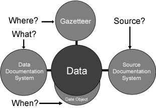
This is a true spatial database in which all content is held in Oracle, although GIS software is used to edit content. It is designed to overcome the limitations of the original system:
- The statistical content is now the core of the system, all data values being held in a single column of a single table, with other columns indicating what the number measures, when and where it is for, and the source it was taken from (Southall, 2007).
- Where is recorded not directly as a location but via a reference to a large catalogue of administrative units. This catalogue is organised as an ontology, each unit having any number of names and at least one IsPartOf relationship with a higher-level unit; the obvious exception is the root unit, which represents the British Isles and to which all other units ultimately belong.
- Almost all the original digital boundaries are included in the new system, but they are held as polygons rather than line segments. Many units, especially those lacking associated statistical data, do not have boundary polygons. Most of these have approximate centroids, inferred from their relationships with units that do have polygons.
- The meaning of the statistical content—the what in the central data table—is recorded via a data documentation subsystem which is another ontology. It was designed as a relational implementation of the aggregate data extension developed by the Data Documentation Initiative. This sub-system does not simply provide text defining variables, it directly drives the graphical presentation of data. Each data value is located within an nCube or Hypercube. For more details, see Southall (2008).
Expanded content
This new version of the GB Historical GIS also included several other kinds of content:
- Descriptive Gazetteers: Over 90,000 entries from three late nineteenth century gazetteers: John Marius Wilson's Imperial Gazetteer of England and Wales (1872); Frances Groome's The Ordnance Gazetteer of Scotland (1885); and John Bartholomew's Gazetteer of the British Isles (1887).
- Reiseliteratur : Die Texte der meisten bekannten britischen Reiseschriftsteller der Geschichte, darunter James Boswell , William Camden , William Cobbett , Daniel Defoe , Celia Fiennes , Charles Wesley und Arthur Young . Die älteste Quelle im GB Historical GIS ist eine 1188 von Giraldus Cambrensis verfasste Vermessung von Wales . Ortsnamen sind in diesen Texten mithilfe von XML-Tags der Text Encoding Initiative (TEI) gekennzeichnet . Es handelt sich hierbei vermutlich um die größte Sammlung britischer historischer Reiseliteratur im Internet; sie ist einzigartig, da sie vollständig georeferenziert ist.
- Volkszählungsberichte : Das Subsystem zur Erfassung statistischer Informationsquellen enthält eine vollständige Liste aller Tabellen, die in britischen Volkszählungsberichten bis 1961 veröffentlicht wurden. Dies ermöglicht dem System die Rekonstruktion ausgewählter Tabellen. Das System enthält außerdem die Einleitungstexte ausgewählter Berichte sowie den Leitfaden zu den Volkszählungsberichten: Großbritannien 1801–1966 .
- Geografische Namensautorität : Die oben beschriebene Ontologie der Verwaltungseinheiten wurde aus völlig unabhängigen Quellen des ursprünglichen GIS erstellt, darunter Frederick Youngs' „ Guide to the Local Administrative Units of England“ , Melville Richards' „Welsh Administrative and Territorial Units“ und ein neues Ortsverzeichnis schottischer Grafschaften, Gemeinden und Städte, das vom Scottish Archives Network erstellt wurde. Sie enthält außerdem zusätzliche Namensvarianten aus Volkszählungsberichten und dient der Kontrolle der Namensautorität .
Alle diese neuen Inhalte werden in derselben Oracle-Datenbank gespeichert und mit den Polygonen und Statistiken verknüpft, die vom ursprünglichen GBHGIS übernommen wurden.
Historische Karten
Ein GIS, das ausschließlich aus administrativen Grenzen besteht, kann zwar Karten erstellen, diese lassen sich jedoch nur schwer mit der Realität in Verbindung bringen. Daher wurde im Rahmen des Projekts ein zweites GIS entwickelt, das ausschließlich aus gescannten Bildern historischer Karten besteht und eine Online-Kartenbibliothek unterstützt.
Drei vollständige Kartensätze Großbritanniens im Maßstab 1:64 (1 Zoll zu 1 Meile) wurden eingescannt und georeferenziert, jeweils begleitet von weniger detaillierten Karten aus der gleichen Zeit:
- Die Ordnance Survey New Popular Edition aus den späten 1940er Jahren. Dies sind die aktuellsten detaillierten Karten Großbritanniens, die nicht mehr dem Urheberrecht der Ordnance Survey unterliegen. Die Karte mit dem kleinsten Maßstab aus dem 20. Jahrhundert ist die „ New Map of the British Isles“, herausgegeben unter der Leitung von A. Gross (London: Geographia, 1921; Signatur der British Library: Maps 1080.(70.)). Die Karte mit mittlerem Maßstab ist die Ordnance Survey of Great Britain im Maßstab 1:633. 600 Karten aus dem Jahr 1904 (Signatur der British Library: Maps 1125.(14.)).
- Die erste Serie der Ordnance Survey-Karten entstand über mehrere Jahrzehnte Mitte des 19. Jahrhunderts. Das GB Historical GIS verwendet für jedes Blatt den frühesten Zustand, der in der British Library aufbewahrt wird . Die am wenigsten detaillierte Karte aus dem 19. Jahrhundert stammt von 1812 und wurde von Robert Wilkinson im Maßstab 1:1.625.000 erstellt (Signatur der British Library: Maps 177.d.2.(15.)). Die Karte im mittleren Maßstab ist Smiths „ New Map of the United Kingdom of Great Britain and Ireland: on which the Turnpike, and Principal Cross Roads, are carefully described. Especially distincting the Route of the mail Coaches, the course of the Rivers, and Navigable canals; ...“ , veröffentlicht 1806 im Maßstab 1:633.600 (Signatur der British Library: Maps 177.d.2.(14.)).
- Die Landnutzungserhebung Großbritanniens (Land Utilisation Survey of Great Britain , LUSGB) wurde von L. Dudley Stamp von der London School of Economics erstellt . Diese Karten umfassen alle veröffentlichten 1-Zoll-Blätter sowie die 56 handkolorierten Aquarellkarten des schottischen Hochlands, die Stamp der Royal Geographical Society (RGS-Kontrollnummer 568206) übergab. Ebenfalls enthalten sind die vom LUSGB veröffentlichten Übersichtsblätter im Maßstab 1:10 Meilen pro Zoll.
Diese Sammlung historischer Karten wird nicht im Hauptsystem von Oracle gespeichert, sondern mithilfe der Open-Source -Software MapServer verwaltet . Der Zugriff erfolgt hauptsächlich über MapServers Implementierung des Web Map Service- Standards des Open Geospatial Consortium (OGC) . So werden sie beispielsweise im Rahmen des Projekts „Vision of Britain“ des GB Historical GIS-Projekts verwendet, stehen aber auch anderen Websites als Basiskarten zur Verfügung.
Statistiken zur Wahlkreisneueinteilung auf konstante Einheiten
Großbritannien hat eine ungewöhnlich hohe Anzahl an Änderungen seiner lokalen Verwaltungsgebiete erlebt, und die heutigen Bezirke stammen entweder aus dem Jahr 1996, 1974 oder, in London, aus dem Jahr 1965. Da die Volkszählung stets auf lokalen Verwaltungseinheiten basierte, ist es schwierig, die langfristige Entwicklung einzelner Gebiete zu untersuchen. Einer der Hauptgründe für den Aufbau des GB Historical GIS war die Möglichkeit, demografische und soziale Statistiken von verschiedenen historischen Einheiten auf moderne Bezirke umzurechnen . Dies geschieht mithilfe einer Vektor-Overlay-Methode, wobei die Bevölkerungszahlen auf Gemeindeebene zur Gewichtung der Neuzuordnung der Bezirksdaten herangezogen werden.
Diese Methodik wurde verwendet, um die wichtigsten Statistiken aus der Veröffentlichung der Schlüsselstatistiken der Volkszählung von 2001 für viele frühere Daten zu replizieren, darunter die Gesamtbevölkerung ab 1801, die Berufsstruktur für ausgewählte Volkszählungen ab 1841 sowie die Alters- und Geschlechtsstruktur für jede Volkszählung ab 1851.
Eine Vision Großbritanniens im Wandel der Zeit
Components of the GB Historical GIS are available for download by academic researchers from the UK Data Archive and from EDINA's UKBorders system. However, the main way most people can access the system is via the Vision of Britain web site, developed by the GB Historical GIS project with their lottery funding.
The site is designed mainly as a resource for studying local history but also includes extensive mapping facilities. It includes home pages both for "places", i.e. towns and villages, and for the individual administrative units based on places. Administrative unit pages provide access to census statistics for the unit, to boundary maps and to formal information on official names and status, relationships with other units and boundary changes. All these web pages are generated by software from the data held in the underlying GB Historical GIS. Many Wikipedia pages refer to Vision of Britain.
Vision of Britain is an unusual web site as it is database-driven, but uses the ontologies in the underlying system to create clickable links between pages: most pages the site can create can be reached without filling out a search form, or clicking on an image map, and this makes the site's content generally accessible to search engines. One result is that Google searches for historical information for particular places in Britain are very likely to return links to Vision of Britain. For the most reliable results, search in Google for "place county history"; for example, "Portsmouth Hampshire History".
For a detailed guide to using the Vision of Britain system for research into local history, see Southall (2006).
GIS status
The post-2000 GB Historical GIS makes no use of commercial GIS software, except for editing parts of the content, and implements a data model which could not be implemented using packages such as ArcGIS or MapInfo, so is it a GIS at all? It is certainly not a conventional GIS, but one answer is that any system that can create an image like the one shown below is some kind of GIS. This image from A Vision of Britain through Time combines the boundaries of local government districts, data on unemployment from the 1931 census, and a scanned image of an Ordnance Survey ten mile-to-one inch map from the early 20th century.

Extended Historical GIS (2007 onwards)
A new system is being developed, partly with funding from the European Union under the QVIZ project, which will no longer be limited to Great Britain:
- The root unit represents the world rather than the British Isles, although more detailed decisions about map projections mean that the system is in practice limited to Europe.
- All coordinates are held using latitude and longitude, not the Ordnance Survey National Grid.
- All geographical names and some other text are held using Unicode (UTF-8).
- Multiple languages are supported, especially when recording geographical names, using Ethnologue codes to identify modern languages and Linguist codes for historical ones.
An enhanced web site based on this extended system was launched in 2009.
References
Notes
- ^Great Britain Historical GIS, Relationships / unit history of The Isles, visionofbritain.org.uk, archived from the original on 2007-12-05, retrieved 2008-10-18
Bibliography
- Gregory, Ian N.; Southall, Humphrey (1998). "Putting the Past in Its Place: the Great Britain Historical GIS". In Carver, S. (ed.). Innovations in GIS 5. Taylor & Francis. pp. 210–21.
- Gregory, Ian N.; Southall, Humphrey (2002). "Mapping British Population History". In Knowles, Anne Kelly (ed.). Past Time, Past Place: GIS for history. ESRI Press. ISBN 1-58948-032-5.
- Southall, Humphrey (2006). A Vision of Britain through Time: Making sense of 200 years of census reports. Local Population Studies. pp. 76–84.
- Southall, Humphrey (2007). A Vision of Britain through Time: On-line access to statistical heritage" Significance, vol. 4, issue 2. pp. 67–70.
- Southall, Humphrey (2008). "Visualization, Data Sharing and Metadata". In Dodge, M.; McDerby, M.; Turner, M. (eds.). Geographical Visualization: Concepts, Tools and Applications. Chichester: John Wiley. pp. 259–75.
Further reading
- Ian Gregory: A Place in History: a Guide to using GIS in Historical Research A short introduction to HGIS by the lead developer of the original GBHGIS AHDS Guides to Good Practice