Europe is a continent[t] located entirely in the Northern Hemisphere and mostly in the Eastern Hemisphere. It is bordered by the Arctic Ocean to the north, the Atlantic Ocean to the west, the Mediterranean Sea to the south, and Asia to the east. Europe shares the landmass of Eurasia with Asia, and of Afro-Eurasia with both Africa and Asia.[9][10] Europe is commonly considered to be separated from Asia by the watershed of the Ural Mountains, the Ural River, the Caspian Sea, the Greater Caucasus, the Black Sea, and the Turkish straits.[11]
Europe covers approximately 10,186,000 square kilometres (3,933,000 sq mi), or 2% of Earth's surface (6.8% of Earth's land area), making it the second-smallest continent (using the seven-continent model). Politically, Europe is divided into about fifty sovereign states, of which Russia is the largest and most populous, spanning 39% of the continent and comprising 15% of its population. Europe had a total population of about 745 million (about 10% of the world population) in 2021; the third-largest after Asia and Africa.[1][2] The European climate is affected by warm Atlantic currents, such as the Gulf Stream, which produce a temperate climate, tempering winters and summers, on much of the continent. Further from the sea, seasonal differences are more noticeable producing more continental climates.
The culture of Europe consists of a range of national and regional cultures, which form the central roots of the wider Western civilisation, and together commonly reference ancient Greece and ancient Rome, particularly through their Christian successors, as crucial and shared roots.[12][13] Beginning with the fall of the Western Roman Empire in 476 CE, Christian consolidation of Europe in the wake of the Migration Period marked the European post-classicalMiddle Ages. The Italian Renaissance spread across many Western European countries, adapting to local contexts and giving rise to distinct national expressions. The renewed humanist emphasis on art and science was among the several factors that contributed to the broader transition to the modern era. Since the Age of Discovery, led by Spain and Portugal, Europe played a predominant role in global affairs with multiple explorations and conquests around the world. Between the 16th and 20th centuries, European powers colonised at various times the Americas, almost all of Africa and Oceania, and the majority of Asia.
The Age of Enlightenment, the French Revolution, and the Napoleonic Wars shaped the continent culturally, politically, and economically from the end of the 17th century until the first half of the 19th century. The Industrial Revolution, which began in Great Britain at the end of the 18th century, gave rise to radical economic, cultural, and social change in Western Europe and eventually the wider world. Both world wars began and were fought to a great extent in Europe, contributing to a decline in Western European dominance in world affairs by the mid-20th century as the Soviet Union and the United States took prominence and competed over ideological dominance and international influence in Europe and globally.[14] The resulting Cold War divided Europe along the Iron Curtain, with NATO in the West and the Warsaw Pact in the East. This divide ended with the Revolutions of 1989, the fall of the Berlin Wall, and the dissolution of the Soviet Union, which allowed European integration to advance significantly.
Die europäische Integration wurde seit 1948 mit der Gründung des Europarats und maßgeblich durch die Verwirklichung der Europäischen Union (EU), die heute den Großteil Europas repräsentiert, institutionell vorangetrieben. [ 15 ] Die Europäische Union ist ein supranationales politisches Gebilde , das zwischen Konföderation und Föderation angesiedelt ist und auf einem System europäischer Verträge basiert . [ 16 ] Die EU entstand in Westeuropa, dehnt sich aber seit dem Zerfall der Sowjetunion 1991 nach Osten aus. Die meisten ihrer Mitglieder haben den Euro als gemeinsame Währung eingeführt und nehmen am europäischen Binnenmarkt und der Zollunion teil . Ein großer Staatenverbund, der Schengen-Raum , hat zudem die Kontrollen an den Binnengrenzen und die Einwanderung abgeschafft. In der EU finden alle fünf Jahre reguläre Wahlen statt; sie gelten nach den Wahlen in Indien als die zweitgrößten demokratischen Wahlen der Welt . Die EU-Wirtschaft ist gemessen am nominalen BIP die zweitgrößte und gemessen am kaufkraftbereinigten BIP die drittgrößte der Welt .
Etymologie

In classical Greek mythology, Europa (Ancient Greek: Εὐρώπη, Eurṓpē) was a Phoenician princess. One view is that her name derives from the Ancient Greek elements εὐρύς (eurús) 'wide, broad', and ὤψ (ōps, gen.ὠπός, ōpós) 'eye, face, countenance', hence their composite Eurṓpē would mean 'wide-gazing' or 'broad of aspect'.[17][18][19][20]Broad has been an epithet of Earth herself in the reconstructed Proto-Indo-European religion and the poetry devoted to it.[17] An alternative view is that of Robert Beekes, who has argued in favour of a pre-Indo-European origin for the name, explaining that a derivation from eurus would yield a different toponym than Europa. Beekes has located toponyms related to that of Europa in the territory of ancient Greece, and localities such as that of Europos in ancient Macedonia.[21]
There have been attempts to connect Eurṓpē to a Semitic term for west, this being either Akkadianerebu meaning 'to go down, set' (said of the sun) or Phoenician'ereb 'evening, west',[20] which is at the origin of Arabicmaghreb and Hebrewma'arav. Martin Litchfield West stated that "phonologically, the match between Europa's name and any form of the Semitic word is very poor",[22] while Beekes considers a connection to Semitic languages improbable.[21]
Most major world languages use words derived from Eurṓpē or Europa to refer to the continent. Chinese, for example, uses the word Ōuzhōu (歐洲/欧洲), which is an abbreviation of the transliterated name Ōuluóbā zhōu (歐羅巴洲) (zhōu means "continent"); a similar Chinese-derived term Ōshū (欧州) is also sometimes used in Japanese such as in the Japanese name of the European Union, Ōshū Rengō (欧州連合), despite the katakanaYōroppa (ヨーロッパ) being more commonly used. In some Turkic languages, the originally Persian name Frangistan ("land of the Franks") is used casually in referring to much of Europe, besides official names such as Avrupa or Evropa.[23]
Definition
Contemporary definition
Clickable map of Europe, showing one of the most commonly used continental boundaries[u]Key:blue: states which straddle the border between Europe and Asia; green: countries not geographically in Europe, but closely associated with the continent

The prevalent definition of Europe as a geographical term has been in use since the mid-19th century. Europe is taken to be bounded by large bodies of water to the north, west and south; Europe's limits to the east and north-east are usually taken to be the Ural Mountains, the Ural River, and the Caspian Sea; to the south-east, the Caucasus Mountains, the Black Sea, and the waterways connecting the Black Sea to the Mediterranean Sea.[24]


Islands are generally grouped with the nearest continental landmass, hence Iceland is considered to be part of Europe, while the nearby island of Greenland is usually assigned to North America, although politically belonging to Denmark. Nevertheless, there are some exceptions based on sociopolitical and cultural differences. Cyprus is closest to Anatolia (or Asia Minor), but is considered part of Europe politically[25] and it is a member state of the EU. Malta was considered an island of North-western Africa for centuries, but now it is considered to be part of Europe as well.[26] "Europe", as used specifically in British English, may also refer to Continental Europe exclusively.[27]
The term "continent" usually implies the physical geography of a large land mass completely or almost completely surrounded by water at its borders. Prior to the adoption of the current convention that includes mountain divides, the border between Europe and Asia had been redefined several times since its first conception in classical antiquity, but always as a series of rivers, seas and straits that were believed to extend an unknown distance east and north from the Mediterranean Sea without the inclusion of any mountain ranges. Cartographer Herman Moll suggested in 1715 that Europe was bounded by a series of partly joined waterways directed towards the Turkish straits, and the Irtysh River draining into the upper part of the Ob River and the Arctic Ocean. In contrast, the present eastern boundary of Europe partially adheres to the Ural and Caucasus Mountains, which is somewhat arbitrary and inconsistent compared to any clear-cut definition of the term "continent".
The current division of Eurasia into two continents now reflects East-West cultural, linguistic and ethnic differences which vary on a spectrum rather than with a sharp dividing line. The geographic border between Europe and Asia does not follow any state boundaries and now only follows a few bodies of water. Turkey is generally considered a transcontinental country divided entirely by water, while Russia and Kazakhstan are only partly divided by waterways. France, the Netherlands, Portugal and Spain are also transcontinental (or more properly, intercontinental, when oceans or large seas are involved) in that their main land areas are in Europe while pockets of their territories are located on other continents separated from Europe by large bodies of water. Spain, for example, has territories (Ceuta and Melilla) south of the Mediterranean Sea which are parts of Africa and share a border with Morocco. According to the current convention, Georgia and Azerbaijan are transcontinental countries where waterways have been completely replaced by mountains as the divide between continents.
History of the concept
Early history

The first recorded usage of Eurṓpē as a geographic term is in the Homeric Hymn to Delian Apollo, in reference to the western shore of the Aegean Sea. As a name for a part of the known world, it is first used in the 6th century BCE by Anaximander and Hecataeus. Anaximander placed the boundary between Asia and Europe along the Phasis River (the modern Rioni River on the territory of Georgia) in the Caucasus, a convention still followed by Herodotus in the 5th century BCE.[28] Herodotus mentioned that the world had been divided by unknown persons into three parts—Europe, Asia, and Libya (Africa)—with the Nile and the Phasis forming their boundaries—though he also states that some considered the River Don, rather than the Phasis, as the boundary between Europe and Asia.[29] Europe's eastern frontier was defined in the 1st century by geographer Strabo at the River Don.[30] The Book of Jubilees described the continents as the lands given by Noah to his three sons; Europe was defined as stretching from the Pillars of Hercules at the Strait of Gibraltar, separating it from Northwest Africa, to the Don, separating it from Asia.[31]
The convention received by the Middle Ages and surviving into modern usage is that of the Roman era used by Roman-era authors such as Posidonius,[32]Strabo,[33] and Ptolemy,[34] who took the Tanais (the modern Don River) as the boundary.
The Roman Empire did not attach a strong identity to the concept of continental divisions. However, following the fall of the Western Roman Empire, the culture that developed in its place, linked to Latin and the Catholic church, began to associate itself with the concept of "Europe".[35] The term "Europe" is first used for a cultural sphere in the Carolingian Renaissance of the 9th century. From that time, the term designated the sphere of influence of the Western Church, as opposed to both the Eastern Orthodox churches and to the Islamic world.
Im 8. Jahrhundert kristallisierte sich eine kulturelle Definition Europas als der Gebiete des lateinischen Christentums heraus. Sie bezeichnete das neue kulturelle Kondominium, das durch das Zusammenfließen germanischer Traditionen und christlich-lateinischer Kultur entstand und sich teilweise in Abgrenzung zu Byzanz und dem Islam definierte . Europa umfasste zunächst die nördliche Iberische Halbinsel , die Britischen Inseln, Frankreich, das christianisierte Westdeutschland, die Alpenregionen sowie Nord- und Mittelitalien. [ 36 ] [ 37 ] Dieses Konzept zählt zu den bleibenden Vermächtnissen der karolingischen Renaissance : Europa taucht häufig in den Briefen von Alkuin , dem Hofgelehrten Karls des Großen, auf . [ 38 ] Der Wandel Europas von einem geografischen zu einem kulturellen Begriff führte dazu, dass die Grenzen Europas von kulturellen Überlegungen im Osten beeinflusst wurden, insbesondere in Bezug auf Gebiete unter byzantinischem, osmanischem und russischem Einfluss. Diese Fragen waren von den positiven Konnotationen geprägt, die der Begriff Europa verband. Solche kulturellen Überlegungen wurden trotz der Eroberung und Besiedlung Amerikas durch europäische Staaten nicht angewendet. Stattdessen entstand der Begriff der „westlichen Zivilisation“ als Mittel, Europa und diese Kolonien zusammenzufassen. [ 39 ]
Moderne Definitionen


Die Frage nach der genauen Festlegung der Ostgrenze Europas stellte sich in der Frühen Neuzeit, als die östliche Ausdehnung Moskaus begann, Nordasien mit einzuschließen . Im gesamten Mittelalter und bis ins 18. Jahrhundert folgte die traditionelle Aufteilung Eurasiens in die beiden Kontinente Europa und Asien der ptolemäischen Auffassung, wobei die Grenze den türkischen Meerengen , dem Schwarzen Meer , der Straße von Kertsch , dem Asowschen Meer und dem Don (dem antiken Tanais ) folgte. Karten des 16. bis 18. Jahrhunderts unterschieden sich jedoch häufig darin, wie die Grenze jenseits der Donschleife bei Kalatsch-na-Donu (wo der Don der Wolga, die heute durch den Wolga-Don-Kanal mit ihr verbunden ist, am nächsten liegt ) in ein Gebiet zu führen war, das von den antiken Geographen nicht detailliert beschrieben worden war.
Around 1715, Herman Moll produced a map showing the northern part of the Ob River and the Irtysh River, a major tributary of the Ob, as components of a series of partly joined waterways taking the boundary between Europe and Asia from the Turkish Straits, and the Don River all the way to the Arctic Ocean. In 1721, he produced a more up to date map that was easier to read. However, his proposal to adhere to major rivers as the line of demarcation was never taken up by other geographers who were beginning to move away from the idea of water boundaries as the only legitimate divides between Europe and Asia.
Four years later, in 1725, Philip Johan von Strahlenberg was the first to depart from the classical Don boundary. He drew a new line along the Volga, following the Volga north until the Samara Bend, along Obshchy Syrt (the drainage divide between the Volga and Ural Rivers), then north and east along the latter waterway to its source in the Ural Mountains. At this point he proposed that mountain ranges could be included as boundaries between continents as alternatives to nearby waterways. Accordingly, he drew the new boundary north along the Ural Mountains rather than the nearby and parallel running Ob and Irtysh rivers.[40] This was endorsed by the Russian Empire and introduced the convention that would eventually become commonly accepted. However, this did not come without criticism. Voltaire, writing in 1760 about Peter the Great's efforts to make Russia more European, ignored the whole boundary question with his claim that neither Russia, Scandinavia, northern Germany, nor Poland were fully part of Europe.[35] Since then, many modern analytical geographers like Halford Mackinder have declared that they see little validity in the Ural Mountains as a boundary between continents.[41]
The mapmakers continued to differ on the boundary between the lower Don and Samara well into the 19th century. The 1745 atlas published by the Russian Academy of Sciences has the boundary follow the Don beyond Kalach as far as Serafimovich before cutting north towards Arkhangelsk, while other 18th- to 19th-century mapmakers such as John Cary followed Strahlenberg's prescription. To the south, the Kuma–Manych Depression was identified c. 1773 by a German naturalist, Peter Simon Pallas, as a valley that once connected the Black Sea and the Caspian Sea,[42][43] and subsequently was proposed as a natural boundary between continents.
By the mid-19th century, there were three main conventions, one following the Don, the Volga–Don Canal and the Volga, the other following the Kuma–Manych Depression to the Caspian and then the Ural River, and the third abandoning the Don altogether, following the Greater Caucasus watershed to the Caspian. The question was still treated as a "controversy" in geographical literature of the 1860s, with Douglas Freshfield advocating the Caucasus crest boundary as the "best possible", citing support from various "modern geographers".[44]
In Russia and the Soviet Union, the boundary along the Kuma–Manych Depression was the most commonly used as early as 1906.[45] In 1958, the Soviet Geographical Society formally recommended that the boundary between the Europe and Asia be drawn in textbooks from Baydaratskaya Bay, on the Kara Sea, along the eastern foot of Ural Mountains, then following the Ural River until the Mugodzhar Hills, and then the Emba River; and Kuma–Manych Depression,[46] thus placing the Caucasus entirely in Asia and the Urals entirely in Europe.[47] The Flora Europaea adopted a boundary along the Terek and Kuban rivers, so southwards from the Kuma and the Manych, but still with the Caucasus entirely in Asia.[48][49] However, most geographers in the Soviet Union favoured the boundary along the Caucasus crest,[50] and this became the common convention in the later 20th century, although the Kuma–Manych boundary remained in use in some 20th-century maps.
Martin W. Lewis and Kären Wigen argue that the separation of Eurasia into Asia and Europe of vastly uneven sizes produces a false impression of parity between European and Asian countries, as a residue of Eurocentrism: "In physical, cultural and historical diversity, China and India are comparable to the entire European landmass, not to a single European country."[51]
History
Prehistory
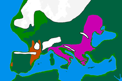


During the 2.5 million years of the Pleistocene, numerous cold phases called glacials (Quaternary ice age), or significant advances of continental ice sheets, in Europe and North America, occurred at intervals of approximately 40,000 to 100,000 years. The long glacial periods were separated by more temperate and shorter interglacials which lasted about 10,000–15,000 years. The last cold episode of the last glacial period ended about 10,000 years ago.[53] Earth is currently in an interglacial period of the Quaternary, called the Holocene.[54]
Homo erectus georgicus, which lived roughly 1.8 million years ago in Georgia, is the earliest hominin to have been discovered in Europe.[55]Other hominin remains, dating back roughly 1 million years, have been discovered in Atapuerca, Spain.[56]Neanderthal man (named after the Neandertal valley in Germany) appeared in Europe 150,000 years ago (115,000 years ago it is found already in the territory of present-day Poland[57]) and disappeared from the fossil record about 40,000 years ago,[58] with their final refuge being the Iberian Peninsula. The Neanderthals were supplanted by modern humans (Cro-Magnons), who seem to have appeared in Europe around 43,000 to 40,000 years ago.[59] However, there is also evidence that Homo sapiens arrived in Europe around 54,000 years ago, some 10,000 years earlier than previously thought.[60] The earliest sites in Europe dated 48,000 years ago are Riparo Mochi (Italy), Geissenklösterle (Germany) and Isturitz (France).[61][62]
Das europäische Neolithikum – gekennzeichnet durch Ackerbau, Viehzucht, eine Zunahme von Siedlungen und die weitverbreitete Verwendung von Keramik – begann um 7000 v. Chr. in Griechenland und auf dem Balkan , vermutlich beeinflusst von früheren landwirtschaftlichen Praktiken in Anatolien und dem Nahen Osten . [ 63 ] Es breitete sich vom Balkan entlang der Donau- und Rheintäler ( Linearkeramik ) und entlang der Mittelmeerküste ( Cardialkultur ) aus. Zwischen 4500 und 3000 v. Chr. entwickelten sich diese mitteleuropäischen neolithischen Kulturen weiter nach Westen und Norden und gaben neu erworbene Fertigkeiten in der Kupferverarbeitung weiter. In Westeuropa war das Neolithikum nicht durch große landwirtschaftliche Siedlungen, sondern durch Feldmonumente wie Wallanlagen , Grabhügel und Megalithgräber geprägt . [ 64 ] Die Schnurkeramik erlebte ihre Blütezeit am Übergang vom Neolithikum zum Chalkolithikum . In dieser Zeit wurden in ganz West- und Südeuropa gigantische Megalithbauten errichtet , wie beispielsweise die Megalithtempel von Malta und Stonehenge . [ 65 ] [ 66 ]
Die heutigen indigenen Bevölkerungen Europas stammen größtenteils von drei verschiedenen Abstammungslinien ab: [ 67 ] Mesolithische Jäger und Sammler , Nachkommen der paläolithischen Epigravettien -Kultur; [ 52 ] frühe europäische Bauern des Neolithikums , die vor 9.000 Jahren während der Neolithischen Revolution aus Anatolien einwanderten; [ 68 ] und Hirten der Jamnaja- Steppe, die im Zuge der indogermanischen Wanderungen vor 5.000 Jahren aus der pontisch-kaspischen Steppe der Ukraine und Südrusslands nach Europa kamen . [ 67 ] [ 69 ] Die europäische Bronzezeit begann um 3200 v. Chr. in Griechenland mit der minoischen Kultur auf Kreta , der ersten Hochkultur Europas. [ 70 ] Auf die Minoer folgten die Mykener , deren Kultur um 1200 v. Chr. plötzlich unterging und damit die europäische Eisenzeit einleitete . [ 71 ] Die Kolonisation durch die Griechen und Phönizier in der Eisenzeit führte zur Entstehung früher Mittelmeerstädte . Das frühe Italien und Griechenland der Eisenzeit ab etwa dem 8. Jahrhundert v. Chr. bildete die Grundlage für die historische klassische Antike, deren Beginn manchmal auf 776 v. Chr., das Jahr der ersten Olympischen Spiele , datiert wird . [ 72 ]
Klassische Antike
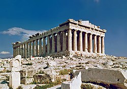
Ancient Greece was the founding culture of Western civilisation. Western democratic and rationalist culture are often attributed to Ancient Greece.[73] The Greek city-state, the polis, was the fundamental political unit of classical Greece.[73] In 508 BCE, Cleisthenes instituted the world's first democratic system of government in Athens.[74] The Greek political ideals were rediscovered in the late 18th century by European philosophers and idealists. Greece also generated many cultural contributions: in philosophy, humanism and rationalism under Aristotle, Socrates and Plato; in history with Herodotus and Thucydides; in dramatic and narrative verse, starting with the epic poems of Homer;[75] in drama with Sophocles and Euripides; in medicine with Hippocrates and Galen; and in science with Pythagoras, Euclid, and Archimedes.[76][77][78] In the course of the 5th century BCE, several of the Greek city states would ultimately check the Achaemenid Persian advance in Europe through the Greco-Persian Wars, considered a pivotal moment in world history,[79] as the 50 years of peace that followed are known as Golden Age of Athens, the seminal period of ancient Greece that laid many of the foundations of Western civilisation.
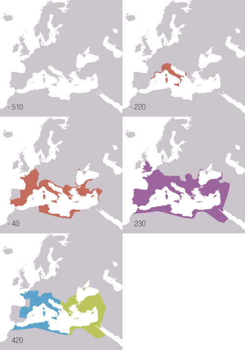
Greece was followed by Rome, which left its mark on law, politics, language, engineering, architecture, government, and many more key aspects in western civilisation.[73] By 200 BCE, Rome had conquered Italy and over the following two centuries it conquered Greece, Hispania (Spain and Portugal), the North African coast, much of the Middle East, Gaul (France and Belgium), and Britannia (England and Wales).
Expanding from their base in central Italy beginning in the third century BCE, the Romans gradually expanded to eventually rule the entire Mediterranean basin and Western Europe by the turn of the millennium. The Roman Republic ended in 27 BCE, when Augustus proclaimed the Roman Empire. The two centuries that followed are known as the pax romana, a period of unprecedented peace, prosperity and political stability in most of Europe.[80] The empire continued to expand under emperors such as Antoninus Pius and Marcus Aurelius, who spent time on the Empire's northern border fighting Germanic, Pictish and Scottish tribes.[81][82]Christianity was legalised by Constantine I in 313 CE after three centuries of imperial persecution. Constantine also permanently moved the capital of the empire from Rome to the city of Byzantium (modern-day Istanbul) which was renamed Constantinople in his honour in 330 CE. Christianity became the sole official religion of the empire in 380 CE, and in 391–392 CE the emperor Theodosius outlawed pagan religions.[83] This is sometimes considered to mark the end of antiquity; alternatively antiquity is considered to end with the fall of the Western Roman Empire in 476 CE; the closure of the pagan Platonic Academy of Athens in 529 CE;[84] or the rise of Islam in the early 7th century CE. During most of its existence, the Byzantine Empire was one of the most powerful economic, cultural, and military forces in Europe.[85]
Early Middle Ages


During the decline of the Roman Empire, Europe entered a long period of change arising from what historians call the "Age of Migrations". There were numerous invasions and migrations amongst the Ostrogoths, Visigoths, Goths, Vandals, Huns, Franks, Angles, Saxons, Slavs, Avars, Bulgars, Vikings, Pechenegs, Cumans, and Magyars.[80]Renaissance thinkers such as Petrarch would later refer to this as the "Dark Ages".[86]
Isolated monastic communities were the only places to safeguard and compile written knowledge accumulated previously; apart from this, very few written records survive. Much literature, philosophy, mathematics, and other thinking from the classical period disappeared from Western Europe, though they were preserved in the east, in the Byzantine Empire.[87]
While the Roman empire in the west continued to decline, Roman traditions and the Roman state remained strong in the predominantly Greek-speaking Eastern Roman Empire, also known as the Byzantine Empire. During most of its existence, the Byzantine Empire was the most powerful economic, cultural, and military force in Europe. Emperor Justinian I presided over Constantinople's first golden age: he established a legal code that forms the basis of many modern legal systems, funded the construction of the Hagia Sophia and brought the Christian church under state control.[88]
From the 7th century onwards, as the Byzantines and neighbouring Sasanid Persians were severely weakened due to the protracted, centuries-lasting and frequent Byzantine–Sasanian wars, the Muslim Arabs began to make inroads into historically Roman territory, taking the Levant and North Africa and making inroads into Asia Minor. In the mid-7th century, following the Muslim conquest of Persia, Islam penetrated into the Caucasus region.[89] Over the next centuries Muslim forces took Cyprus, Malta, Crete, Sicily, and parts of southern Italy.[90] Between 711 and 720, most of the lands of the Visigothic Kingdom of Iberia were brought under Muslim rule—save for small areas in the northwest (Asturias) and largely Basque regions in the Pyrenees. This territory, under the Arabic name Al-Andalus, became part of the expanding Umayyad Caliphate. The unsuccessful second siege of Constantinople (717) weakened the Umayyad dynasty and reduced their prestige. The Umayyads were then defeated by the Frankish leader Charles Martel at the Battle of Poitiers in 732, which ended their northward advance. In the remote regions of north-western Iberia and the middle Pyrenees the power of the Muslims in the south was scarcely felt. It was here that the foundations of the Christian kingdoms of Asturias, Leon, and Galicia were laid and from where the reconquest of the Iberian Peninsula would start. However, no coordinated attempt would be made to drive the Moors out. The Christian kingdoms were mainly focused on their own internal power struggles. As a result, the Reconquista took the greater part of eight hundred years, in which period a long list of Alfonsos, Sanchos, Ordoños, Ramiros, Fernandos, and Bermudos would be fighting their Christian rivals as much as the Muslim invaders.

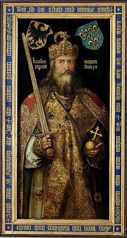
Im Frühmittelalter geriet das Weströmische Reich unter die Herrschaft verschiedener Stämme. Germanische und slawische Stämme etablierten ihre Herrschaftsgebiete in West- bzw. Osteuropa. [ 91 ] Schließlich wurden die fränkischen Stämme unter Chlodwig I. vereint . [ 92 ] Karl der Große , ein fränkischer König aus dem Geschlecht der Karolinger , der den größten Teil Westeuropas erobert hatte, wurde im Jahr 800 vom Papst zum Kaiser des Heiligen Römischen Reiches ernannt . Dies führte 962 zur Gründung des Heiligen Römischen Reiches , dessen Zentrum schließlich in den germanischen Fürstentümern Mitteleuropas lag. [ 93 ]
In Ostmitteleuropa entstanden um 1000 n. Chr. die ersten slawischen Staaten und das Christentum . Der mächtige westslawische Staat Großmähren dehnte sein Territorium bis zum Balkan aus und erreichte unter Swatopluk I. seine größte Ausdehnung , was zu einer Reihe bewaffneter Konflikte mit dem Ostfrankenreich führte . Weiter südlich entstanden im späten 7. und 8. Jahrhundert die ersten südslawischen Staaten , die ebenfalls das Christentum annahmen: das Erste Bulgarische Reich , das Serbische Fürstentum (später Königreich und Kaiserreich ) und das Herzogtum Kroatien (später Königreich Kroatien ). Im Osten expandierte die Kiewer Rus von ihrer Hauptstadt Kiew aus und wurde im 10. Jahrhundert zum größten Staat Europas. 988 erhob Wladimir der Große die Orthodoxie zur Staatsreligion. [ 94 ] [ 95 ] Weiter östlich wurde Wolgabulgarien im 10. Jahrhundert ein islamischer Staat, der jedoch einige Jahrhunderte später in Russland eingegliedert wurde. [ 96 ]
Hoch- und Spätmittelalter

The period between the year 1000 and 1250 is known as the High Middle Ages, followed by the Late Middle Ages until c. 1500.
During the High Middle Ages the population of Europe experienced significant growth, culminating in the Renaissance of the 12th century. Economic growth, together with the lack of safety on the mainland trading routes, made possible the development of major commercial routes along the coast of the Mediterranean and Baltic Seas. The growing wealth and independence acquired by some coastal cities gave the Maritime Republics a leading role in the European scene.
The Middle Ages on the mainland were dominated by the two upper echelons of the social structure: the nobility and the clergy. Feudalism developed in France in the Early Middle Ages, and soon spread throughout Europe.[99] A struggle for influence between the nobility and the monarchy in England led to the writing of Magna Carta and the establishment of a parliament.[100] The primary source of culture in this period came from the Roman Catholic Church. Through monasteries and cathedral schools, the Church was responsible for education in much of Europe.[99]

The Papacy reached the height of its power during the High Middle Ages. An East-West Schism in 1054 split the former Roman Empire religiously, with the Eastern Orthodox Church in the Byzantine Empire and the Roman Catholic Church in the former Western Roman Empire. In 1095 Pope Urban II called for a crusade against Muslims occupying Jerusalem and the Holy Land.[101] In Europe itself, the Church organised the Inquisition against heretics. In the Iberian Peninsula, the Reconquista concluded with the fall of Granada in 1492, ending over seven centuries of Islamic rule in the south-western peninsula.[102]
In the east, a resurgent Byzantine Empire recaptured Crete and Cyprus from the Muslims, and reconquered the Balkans. Constantinople was the largest and wealthiest city in Europe from the 9th to the 12th centuries, with a population of approximately 400,000.[103] The Empire was weakened following the defeat at Manzikert, and was weakened considerably by the sack of Constantinople in 1204, during the Fourth Crusade.[104][105][106][107][108][109][110][111][112] Although it would recover Constantinople in 1261, Byzantiumfell in 1453 when Constantinople was taken by the Ottoman Empire.[113][114][115]

In the 11th and 12th centuries, constant incursions by nomadic Turkic tribes, such as the Pechenegs and the Cuman-Kipchaks, caused a massive migration of Slavic populations to the safer, heavily forested regions of the north, and temporarily halted the expansion of Kievan Rus' to the south and east.[116] The Mongols invaded Europe in the mid-13th century, and together with their mostly Turkic subjects, became known as Tatars.[117] These Tatars ruled the Russian principalities through vassalage for the next 200 years.[118][119] After the collapse of Mongol dominions, the first Romanian states (principalities) emerged in the 14th century: Moldavia and Walachia. Previously, these territories were under the successive control of Pechenegs and Cumans.[120] The Grand Principality of Moscow became the dominant Russian principality, forming in the process a centralized, autocratic Russian state by the late 15th century.[121][122] The Great Stand on the Ugra River in 1480 traditionally marks the end of the "Tatar yoke" over Russia.[122]
The Great Famine of 1315–1317 was the first crisis that would strike Europe in the late Middle Ages.[123] The period between 1348 and 1420 witnessed the heaviest loss. The population of France was reduced by half.[124][125] Medieval Britain was afflicted by 95 famines,[126] and France suffered the effects of 75 or more in the same period.[127] Europe was devastated in the mid-14th century by the Black Death, one of the most deadly pandemics in human history which killed an estimated 25 million people in Europe alone—a third of the European population at the time.[128]
The plague had a devastating effect on Europe's social structure; it induced people to live for the moment as illustrated by Giovanni Boccaccio in The Decameron (1353). It was a serious blow to the Roman Catholic Church and led to increased persecution of Jews, beggars and lepers.[129] The plague is thought to have returned every generation with varying virulence and mortalities until the 18th century.[130] During this period, more than 100 plague epidemics swept across Europe.[131]
Early modern period

The Renaissance was a period of cultural change originating in Florence, and later spreading to the rest of Europe. The rise of a new humanism was accompanied by the recovery of forgotten classical Greek and Arabic knowledge from monastic libraries, often translated from Arabic into Latin.[132][133][134] The Renaissance spread across Europe between the 14th and 16th centuries: it saw the flowering of art, philosophy, music, and the sciences, under the joint patronage of royalty, the nobility, the Catholic Church and an emerging merchant class.[135][136][137] Patrons in Italy, including the Medici family of Florentine bankers and the popes in Rome, funded prolific quattrocento and cinquecento artists such as Raphael, Michelangelo and Leonardo da Vinci.[138][139]
Political intrigue within the Church in the mid-14th century caused the Western Schism. During this 40-year period, two popes—one in Avignon and one in Rome—claimed rulership over the Church. Although the schism was eventually healed in 1417, the papacy's spiritual authority had suffered greatly.[140] In the 15th century, Europe started to extend itself beyond its geographic frontiers. Spain and Portugal, the greatest naval powers of the time, took the lead in exploring the world.[141][142] Exploration reached the Southern Hemisphere in the Atlantic and the southern tip of Africa. Christopher Columbus reached the New World in 1492, and Vasco da Gama opened the ocean route to the East, linking the Atlantic and Indian Oceans in 1498. The Portuguese-born explorer Ferdinand Magellan reached Asia westward across the Atlantic and the Pacific Oceans in a Spanish expedition, resulting in the first circumnavigation of the globe, completed by the Spaniard Juan Sebastián Elcano (1519–1522). Soon after, the Spanish and Portuguese began establishing large global empires in the Americas, Asia, Africa and Oceania.[143] France, the Netherlands and England soon followed in building large colonial empires with vast holdings in Africa, the Americas and Asia. In 1588, the Spanish Armada failed to invade England. A year later, England tried unsuccessfully to invade Spain, allowing Philip II of Spain to maintain his dominant war capacity in Europe. This English disaster also allowed the Spanish fleet to retain its capability to wage war for the next decades. However, two more Spanish armadas failed to invade England (2nd Spanish Armada and 3rd Spanish Armada).[144][145][146][147]

The Church's power was further weakened by the Reformation, which began in 1517 when German theologian Martin Luther nailed his Ninety-five Theses criticising the selling of indulgences to the church door. He was subsequently excommunicated in the papal bull Exsurge Domine in 1520 and his followers were condemned in the 1521 Diet of Worms, which divided German princes between Protestant and Catholic faiths.[149]Religious fighting and warfare spread with Protestantism.[150] The plunder of the empires of the Americas allowed Spain to finance religious persecution in Europe for over a century.[151] The Thirty Years' War (1618–1648) crippled the Holy Roman Empire and devastated much of Germany, killing between 25 and 40 percent of its population.[152] In the aftermath of the Peace of Westphalia, France rose to predominance within Europe.[153] The defeat of the Ottoman Turks at the Battle of Vienna in 1683 marked the historic end of Ottoman expansion into Europe.[154]
In much of Central and Eastern Europe, the 17th century was a period of general decline;[155] the region experienced more than 150 famines in a 200-year period between 1501 and 1700.[156] From the Union of Krewo (1385) east-central Europe was dominated by the Kingdom of Poland and the Grand Duchy of Lithuania. The hegemony of the vast Polish–Lithuanian Commonwealth had ended with the devastation brought by the Northern War of 1655–1660 (Deluge) and subsequent conflicts;[157] the state itself was partitioned and ceased to exist at the end of the 18th century.[158]
Vom 15. bis zum 18. Jahrhundert, als die zerfallenden Khanate der Goldenen Horde von Russland erobert wurden , überfielen Tataren aus dem Krimkhanat häufig Osteuropa, um Sklaven zu erbeuten . [ 159 ] Weiter östlich überfielen die Nogai-Horde und das Kasachische Khanat über Jahrhunderte hinweg immer wieder die slawischsprachigen Gebiete des heutigen Russlands und der Ukraine, bis zur russischen Expansion und Eroberung des größten Teils Nordeurasiens (d. h. Osteuropa, Zentralasien und Sibirien).
Die Renaissance und die neuen Monarchien markierten den Beginn des Zeitalters der Entdeckungen, einer Periode der Erforschung, Erfindung und wissenschaftlichen Entwicklung. [ 160 ] Zu den bedeutenden Persönlichkeiten der wissenschaftlichen Revolution im 16. und 17. Jahrhundert zählten Kopernikus , Kepler , Galilei und Isaac Newton . [ 161 ] Peter Barrett zufolge gilt es als allgemein anerkannt, dass die „moderne Wissenschaft“ im Europa des 17. Jahrhunderts (gegen Ende der Renaissance) entstand und ein neues Verständnis der Natur einführte. [ 132 ]
18. und 19. Jahrhundert

Der Siebenjährige Krieg beendete das „alte System“ der Bündnisse in Europa . Als sich der Amerikanische Unabhängigkeitskrieg zwischen 1778 und 1783 zu einem globalen Krieg ausweitete, sah sich Großbritannien folglich einer starken Koalition europäischer Mächte gegenüber und hatte keinen bedeutenden Verbündeten. [ 162 ]
The Age of Enlightenment was a powerful intellectual movement during the 18th century promoting scientific and reason-based thoughts.[163][164][165] Discontent with the aristocracy and clergy's monopoly on political power in France resulted in the French Revolution, and the establishment of the First Republic as a result of which the monarchy and many of the nobility perished during the initial reign of terror.[166]Napoleon Bonaparte rose to power in the aftermath of the French Revolution, and established the First French Empire that, during the Napoleonic Wars, grew to encompass large parts of Europe before collapsing in 1815 with the Battle of Waterloo.[167][168]Napoleonic rule resulted in the further dissemination of the ideals of the French Revolution, including that of the nation state, as well as the widespread adoption of the French models of administration, law and education.[169][170][171] The Congress of Vienna, convened after Napoleon's downfall, established a new balance of power in Europe centred on the five "great powers": the UK, France, Prussia, Austria, and Russia.[172] This balance would remain in place until the Revolutions of 1848, during which liberal uprisings affected all of Europe except for Russia and the UK. These revolutions were eventually put down by conservative elements and few reforms resulted.[173] The year 1859 saw the unification of Romania, as a nation state, from smaller principalities. In 1867, the Austro-Hungarian empire was formed; 1871 saw the unifications of both Italy and Germany as nation-states from smaller principalities.[174]
In parallel, the Eastern Question grew more complex ever since the Ottoman defeat in the Russo-Turkish War (1768–1774). As the dissolution of the Ottoman Empire seemed imminent, the Great Powers struggled to safeguard their strategic and commercial interests in the Ottoman domains. The Russian Empire stood to benefit from the decline, whereas the Habsburg Empire and Britain perceived the preservation of the Ottoman Empire to be in their best interests. Meanwhile, the Serbian Revolution (1804) and Greek War of Independence (1821) marked the beginning of the end of Ottoman rule in the Balkans, which ended with the Balkan Wars in 1912–1913.[175] Formal recognition of the de facto independent principalities of Montenegro, Serbia and Romania ensued at the Congress of Berlin in 1878.

The Industrial Revolution began in Great Britain in the last part of the 18th century and spread throughout Europe. The invention and implementation of new technologies resulted in rapid urban growth, mass employment and the rise of a new working class.[176] Reforms in social and economic spheres followed, including the first laws on child labour, the legalisation of trade unions,[177] and the abolition of slavery.[178] In Britain, the Public Health Act 1875 was passed, which significantly improved living conditions in many British cities.[179] Europe's population increased from about 100 million in 1700 to 400 million by 1900.[180] The last major famine recorded in Western Europe, the Great Famine of Ireland, caused death and mass emigration of millions of Irish people.[181] In the 19th century, 70 million people left Europe in migrations to various European colonies abroad and to the United States.[182] The industrial revolution also led to large population growth, and the share of the world population living in Europe reached a peak of slightly above 25% around the year 1913.[183][184]
20th century to the present

Two world wars and an economic depression dominated the first half of the 20th century. The First World War was fought between 1914 and 1918. It started when Archduke Franz Ferdinand of Austria was assassinated by the Yugoslav nationalist[185]Gavrilo Princip.[186] Most European nations were drawn into the war, which was fought between the Entente Powers (France, Belgium, Serbia, Portugal, Russia, the United Kingdom, and later Italy, Greece, Romania, and the United States) and the Central Powers (Austria-Hungary, Germany, Bulgaria, and the Ottoman Empire). The war left more than 16 million civilians and military dead.[187] Over 60 million European soldiers were mobilised from 1914 to 1918.[188]

Russia was plunged into the Russian Revolution, which threw down the Tsarist monarchy and replaced it with the communistSoviet Union,[189] leading also to the independence of many former Russian governorates, such as Finland, Estonia, Latvia and Lithuania, as new European countries.[190]Austria-Hungary and the Ottoman Empire collapsed and broke up into separate nations, and many other nations had their borders redrawn. The Treaty of Versailles, which officially ended the First World War in 1919, was harsh towards Germany, upon whom it placed full responsibility for the war and imposed heavy sanctions.[191] Excess deaths in Russia over the course of the First World War and the Russian Civil War (including the postwar famine) amounted to a combined total of 18 million.[192] In 1932–1933, under Stalin's leadership, confiscations of grain by the Soviet authorities contributed to the second Soviet famine which caused millions of deaths;[193] surviving kulaks were persecuted and many sent to Gulags to do forced labour. Stalin was also responsible for the Great Purge of 1937–38 in which the NKVD executed 681,692 people;[194] millions of people were deported and exiled to remote areas of the Soviet Union.[195]


The social revolutions sweeping through Russia also affected other European nations following The Great War: in 1919, with the Weimar Republic in Germany and the First Austrian Republic; in 1922, with Mussolini's one-party fascist government in the Kingdom of Italy and in Atatürk's Turkish Republic, adopting the Western alphabet and state secularism. Economic instability, caused in part by debts incurred in the First World War and 'loans' to Germany played havoc in Europe in the late 1920s and 1930s. This, and the Wall Street crash of 1929, brought about the worldwide Great Depression. Helped by the economic crisis, social instability and the threat of communism, fascist movements developed throughout Europe placing Adolf Hitler in power of what became Nazi Germany.[201][202]
In 1933, Hitler became the leader of Germany and began to work towards his goal of building Greater Germany. Germany re-expanded and took back the Saarland and Rhineland in 1935 and 1936. In 1938, Austria became a part of Germany following the Anschluss. Following the Munich Agreement signed by Germany, France, the United Kingdom, and Italy, later in 1938 Germany annexed the Sudetenland, which was a part of Czechoslovakia inhabited by ethnic Germans. In early 1939, the remainder of Czechoslovakia was split into the Protectorate of Bohemia and Moravia, controlled by Germany and the Slovak Republic. At the time, the United Kingdom and France preferred a policy of appeasement.
With tensions mounting between Germany and Poland over the future of Danzig, the Germans turned to the Soviets and signed the Molotov–Ribbentrop Pact, which allowed the Soviets to invade the Baltic states and parts of Poland and Romania. Germany invaded Poland on 1 September 1939, prompting France and the United Kingdom to declare war on Germany on 3 September, opening the European theatre of the Second World War.[203][204][205] The Soviet invasion of Poland started on 17 September and Poland fell soon thereafter. On 24 September, the Soviet Union attacked the Baltic countries and, on 30 November, Finland, the latter of which was followed by the devastating Winter War for the Red Army.[206] The British hoped to land at Narvik and send troops to aid Finland, but their primary objective in the landing was to encircle Germany and cut the Germans off from Scandinavian resources. Around the same time, Germany moved troops into Denmark. The Phoney War continued.
In May 1940, Germany attacked France through the Low Countries. France capitulated in June 1940. By August, Germany had begun a bombing offensive against the United Kingdom but failed to convince the Britons to give up.[207] In 1941, Germany invaded the Soviet Union in Operation Barbarossa.[208] On 7 December 1941 Japan's attack on Pearl Harbor drew the United States into the conflict as allies of the British Empire, and other allied forces.[209][210]

After the staggering Battle of Stalingrad in 1943, the German offensive in the Soviet Union turned into a continual fallback. The Battle of Kursk, which involved the largest tank battle in history, was the last major German offensive on the Eastern Front. In June 1944, British and American forces invaded France in the D-Day landings, opening a new front against Germany. Berlin finally fell in 1945, ending the Second World War in Europe. The war was the largest and most destructive in human history, with 60 million dead across the world.[211] More than 40 million people in Europe had died as a result of the Second World War,[212] including between 11 and 17 million people who perished during the Holocaust.[213] The Soviet Union lost around 27 million people (mostly civilians) during the war, about half of all Second World War casualties.[214] By the end of the Second World War, Europe had more than 40 million refugees.[215][216][217] Several post-war expulsions in Central and Eastern Europe displaced a total of about 20 million people.[218]
The First World War, and especially the Second World War, diminished the eminence of Western Europe in world affairs. After the Second World War the map of Europe was redrawn at the Yalta Conference and divided into two blocs, the Western countries and the communist Eastern bloc, separated by what was later called by Winston Churchill an "Iron Curtain". The United States and Western Europe established the NATO alliance and, later, the Soviet Union and Central Europe established the Warsaw Pact.[219] Particular hot spots after the Second World War were Berlin and Trieste, whereby the Free Territory of Trieste, founded in 1947 with the UN, was dissolved in 1954 and 1975, respectively. The Berlin blockade in 1948 and 1949 and the construction of the Berlin Wall in 1961 were one of the great international crises of the Cold War.[220][221][222]
The two new superpowers, the United States and the Soviet Union, became locked in a fifty-year-long Cold War, centred on nuclear proliferation. At the same time decolonisation, which had already started after the First World War, gradually resulted in the independence of most of the European colonies in Asia and Africa.[14]
In the 1980s the reforms of Mikhail Gorbachev and the Solidarity movement in Poland weakened the previously rigid communist system. The opening of the Iron Curtain at the Pan-European Picnic then set in motion a peaceful chain reaction, at the end of which the Eastern bloc, the Warsaw Pact and other communist states collapsed, and the Cold War ended.[224][225][226] Germany was reunited, after the symbolic fall of the Berlin Wall in 1989 and the maps of Central and Eastern Europe were redrawn once more.[227] This made old previously interrupted cultural and economic relationships possible, and previously isolated cities such as Berlin, Prague, Vienna, Budapest and Trieste were now again in the centre of Europe.[201][228][229][230]
European integration also grew after the Second World War. In 1949 the Council of Europe was founded, following a speech by Sir Winston Churchill, with the idea of unifying Europe[15] to achieve common goals. It includes all European states except for Belarus, Russia,[231] and Vatican City. The Treaty of Rome in 1957 established the European Economic Community between six Western European states with the goal of a unified economic policy and common market.[232] In 1967 the EEC, European Coal and Steel Community, and Euratom formed the European Community, which in 1993 became the European Union. The EU established a parliament, a court and a central bank, and introduced the euro as a unified currency.[233] Between 2004 and 2013, more Central European countries began joining, expanding the EU to 28 European countries and once more making Europe a major economical and political centre of power.[234] However, the United Kingdom withdrew from the EU on 31 January 2020, as a result of a June 2016 referendum on EU membership.[235] The Russo-Ukrainian War steeply escalated after the 2022 Russian invasion of Ukraine on 24 February 2022, marking the largest humanitarian and refugee crisis in Europe since the Second World War[236] and the Yugoslav Wars.[237]
Geography

Europe makes up the western fifth of the Eurasian landmass.[24] It has a higher ratio of coast to landmass than any other continent or subcontinent.[238] Its maritime borders consist of the Arctic Ocean to the north, the Atlantic Ocean to the west and the Mediterranean, Black and Caspian Seas to the south.[239] Land relief in Europe shows great variation within relatively small areas. The southern regions are more mountainous, while moving north the terrain descends from the high Alps, Pyrenees and Carpathians, through hilly uplands, into broad, low northern plains, which are vast in the east. This extended lowland is known as the Great European Plain and at its heart lies the North German Plain. An arc of uplands also exists along the north-western seaboard, which begins in the western parts of the islands of Britain and Ireland, and then continues along the mountainous, fjord-cut spine of Norway.
This description is simplified. Subregions such as the Iberian Peninsula and the Italian Peninsula contain their own complex features, as does mainland Central Europe itself, where the relief contains many plateaus, river valleys and basins that complicate the general trend. Sub-regions like Iceland, Britain and Ireland are special cases. The former is a land unto itself in the northern ocean that is counted as part of Europe, while the latter are upland areas that were once joined to the mainland until rising sea levels cut them off.
The largest European lakes are located in the north of the continent. The Volga and Danube are the two longest rivers of Europe. Europe's largest waterfall (by flow rate) are the Rhine Falls on the Rhine.
Climate

Europa liegt größtenteils in der gemäßigten Klimazone der Nordhalbkugel, wo die vorherrschende Windrichtung aus Westen kommt . Das Klima ist im Vergleich zu anderen Gebieten auf demselben Breitengrad weltweit milder, bedingt durch den Einfluss des Golfstroms , einer Meeresströmung, die warmes Wasser aus dem Golf von Mexiko über den Atlantik nach Europa transportiert. [ 240 ] Der Golfstrom wird auch als „Europas Zentralheizung“ bezeichnet, da er das europäische Klima wärmer und feuchter macht, als es sonst wäre. Der Golfstrom transportiert nicht nur warmes Wasser an Europas Küste, sondern erwärmt auch die vorherrschenden Westwinde, die vom Atlantik über den Kontinent wehen.
Die durchschnittliche Jahrestemperatur in Aveiro beträgt daher 16 °C, während sie in New York City, das fast auf demselben Breitengrad liegt und an denselben Ozean grenzt, nur 13 °C beträgt. Berlin (Deutschland), Calgary (Kanada) und Irkutsk im äußersten Südosten Russlands liegen etwa auf demselben Breitengrad; die Januartemperaturen in Berlin sind durchschnittlich etwa 8 °C höher als in Calgary und fast 22 °C höher als die Durchschnittstemperaturen in Irkutsk. [ 240 ]
Die großen Wassermassen des Mittelmeers , die die Temperaturen im Jahres- und Tagesmittel ausgleichen, sind ebenfalls von besonderer Bedeutung. Das Mittelmeerwasser erstreckt sich von der Sahara bis zum Alpenbogen in seinem nördlichsten Teil der Adria bei Triest . [ 241 ]
Generell ist es in Europa nicht nur im Norden kälter als im Süden, sondern auch von Westen nach Osten. Das Klima ist im Westen stärker vom Ozean geprägt als im Osten. Dies lässt sich anhand der folgenden Tabelle mit den Durchschnittstemperaturen an Orten veranschaulichen, die ungefähr den Breitengraden 64, 60, 55, 50, 45 und 40 entsprechen . Keiner dieser Orte liegt in großer Höhe; die meisten befinden sich in Meeresnähe.

| Standort | Breite | Länge | kältester Monat | heißester Monat | Jahresdurchschnitt |
|---|---|---|---|---|---|
| Reykjavík | 64 N | 22 W | 0,1 | 11.2 | 4.7 |
| Umeå | 64 N | 20 E | −6,2 | 16.0 | 3.9 |
| Oulu | 65 N | 25,5 E | −9,6 | 16,5 | 2.7 |
| Archangelsk | 64,5 N | 40,5 E | −12,7 | 16.3 | 1.3 |
| Lerwick | 60 N | 1 W | 3,5 | 12.4 | 7.4 |
| Stockholm | 59,5 N | 19 E | −1,7 | 18.4 | 7.4 |
| Helsinki | 60 N | 25 E | −4,7 | 17.8 | 5.9 |
| Sankt Petersburg | 60 N | 30 E | −5,8 | 18.8 | 5.8 |
| Edinburgh | 55,5 N | 3 W | 4.2 | 15.3 | 9.3 |
| Kopenhagen | 55,5 N | 12 E | 1.4 | 18.1 | 9.1 |
| Klaipėda | 55,5 N | 21 E | −1,3 | 17.9 | 8.0 |
| Moskau | 55,5 N | 30 E | −6,5 | 19.2 | 5.8 |
| Scilly-Inseln | 50 N | 6 W | 7.9 | 16.9 | 11.8 |
| Brüssel | 50,5 N | 4 E | 3.3 | 18.4 | 10,5 |
| Krakau | 50 N | 20 E | −2,0 | 19.2 | 8,7 |
| Kiew | 50,5 N | 30 E | −3,5 | 20,5 | 8.4 |
| Bordeaux | 45 N | 0 | 6.6 | 21.4 | 13.8 |
| Venedig | 45.5 N | 12 E | 3.3 | 23.0 | 13.0 |
| Belgrade | 45 N | 20 E | 1.4 | 23.0 | 12.5 |
| Astrakhan | 46 N | 48 E | −3.7 | 25.6 | 10.5 |
| Coimbra | 40 N | 8 W | 10.1 | 22.4 | 16.2 |
| Valencia | 39.5 N | 0 | 12.1 | 26.5 | 18.6 |
| Naples | 40.5 N | 14 E | 9.1 | 26.2 | 17.0 |
| Istanbul | 41 N | 29 E | 5.9 | 24.2 | 14.4 |
[243] The average temperatures for the coldest month, as well as the annual average temperatures, drop from the west to the east. For instance, Edinburgh is warmer than Belgrade during the coldest month of the year, although Belgrade is around 10° of latitude farther south.
Climate change

Effects on European countries include warmer weather and increasing frequency and intensity of extreme weather such as heat waves, bringing health risks and effects on ecosystems. European countries are major contributors to global greenhouse gas emissions, although the European Union and governments of several countries have outlined plans to implement climate change mitigation and an energy transition in the 21st century, the European Green Deal being one of these.
Geology

Die geologische Geschichte Europas lässt sich bis zur Entstehung des Baltischen Schildes (Fennoskandinavien) und des Sarmatischen Kratons vor etwa 2,25 Milliarden Jahren zurückverfolgen. Darauf folgte der Wolgo-Uralische Schild, aus dem gemeinsam der Osteuropäische Kraton (≈ Baltica ) hervorging, der Teil des Superkontinents Columbia wurde. Vor etwa 1,1 Milliarden Jahren vereinigten sich Baltica und Arctica (als Teil des Laurentia- Blocks) mit Rodinia und trennten sich später, vor etwa 550 Millionen Jahren, wieder zu Baltica. Vor etwa 440 Millionen Jahren entstand Euramerika aus Baltica und Laurentia; eine weitere Vereinigung mit Gondwana führte zur Bildung von Pangäa . Vor etwa 190 Millionen Jahren trennten sich Gondwana und Laurasia aufgrund der Ausdehnung des Atlantischen Ozeans. Schließlich und sehr bald darauf zerfiel Laurasia selbst erneut in Laurentia (Nordamerika) und den eurasischen Kontinent. Die Landverbindung zwischen den beiden Kontinenten bestand über Grönland über einen beträchtlichen Zeitraum und führte zum Austausch von Tierarten. Seit etwa 50 Millionen Jahren bestimmen steigende und fallende Meeresspiegel die heutige Form Europas und seine Verbindungen zu Kontinenten wie Asien. Europas heutige Form geht auf das späte Tertiär vor etwa fünf Millionen Jahren zurück. [ 248 ]
Die Geologie Europas ist äußerst vielfältig und komplex und prägt die große Bandbreite an Landschaften des Kontinents, von den schottischen Highlands bis zu den sanften Hügeln Ungarns. [ 249 ] Europas markantestes Merkmal ist die Zweiteilung in das hochgebirgige Südeuropa und die riesige, teilweise unter Wasser liegende nördliche Ebene, die sich von Irland im Westen bis zum Uralgebirge im Osten erstreckt. Diese beiden Hälften werden durch die Gebirgsketten der Pyrenäen und der Alpen / Karpaten getrennt . Im Westen wird die nördliche Ebene durch das Skandinavische Gebirge und die Gebirgszüge der Britischen Inseln begrenzt. Zu den größeren Flachwassergebieten, die Teile der nördlichen Ebene überfluten, gehören die Keltische See , die Nordsee , die Ostsee und die Barentssee .
The northern plain contains the old geological continent of Baltica and so may be regarded geologically as the "main continent", while peripheral highlands and mountainous regions in the south and west constitute fragments from various other geological continents. Most of the older geology of western Europe existed as part of the ancient microcontinentAvalonia.
Flora

Having lived side by side with agricultural peoples for millennia, Europe's animals and plants have been profoundly affected by the presence and activities of humans. With the exception of Fennoscandia and northern Russia, few areas of untouched wilderness are currently found in Europe, except for various national parks.
The main natural vegetation cover in Europe is mixed forest. The conditions for growth are very favourable. In the north, the Gulf Stream and North Atlantic Drift warm the continent. Southern Europe has a warm but mild climate. There are frequent summer droughts in this region. Mountain ridges also affect the conditions. Some of these, such as the Alps and the Pyrenees, are oriented east–west and allow the wind to carry large masses of water from the ocean in the interior. Others are oriented south–north (Scandinavian Mountains, Dinarides, Carpathians, Apennines) and because the rain falls primarily on the side of mountains that is oriented towards the sea, forests grow well on this side, while on the other side, the conditions are much less favourable. Few corners of mainland Europe have not been grazed by livestock at some point in time, and the cutting down of the preagricultural forest habitat caused disruption to the original plant and animal ecosystems. The area of primary forest in Europe increased at an average annual rate of 191 000 hectare in 1990–2000, 217 000 ha in 2000–2015 and 153 000 ha in 2015–2025.[250]

Einst waren vermutlich 80 bis 90 Prozent Europas von Wald bedeckt. [ 251 ] Er erstreckte sich vom Mittelmeer bis zum Arktischen Ozean. Obwohl über die Hälfte der ursprünglichen Wälder Europas im Laufe der Jahrhunderte durch Abholzung verschwunden ist , ist noch immer über ein Viertel der europäischen Landfläche bewaldet, beispielsweise die Laub- und Mischwälder, die Taiga Skandinaviens und Russlands, die Mischwälder des Kaukasus und die Korkeichenwälder im westlichen Mittelmeerraum. In jüngster Zeit konnte die Abholzung verlangsamt und viele Bäume wurden gepflanzt. In vielen Fällen wurden jedoch Nadelbaum-Monokulturen als Ersatz für die ursprünglichen natürlichen Mischwälder genutzt, da Nadelbäume schneller wachsen. Die Plantagen bedecken mittlerweile riesige Flächen, bieten aber schlechtere Lebensräume für viele europäische Waldarten, die eine Mischung verschiedener Baumarten und eine vielfältige Waldstruktur benötigen. Der Anteil an Naturwald in Westeuropa beträgt nur 2–3 % oder weniger, während er in Westrussland 5–10 % beträgt. Das europäische Land mit dem geringsten Anteil an Waldfläche ist Island (1 %), während Finnland mit 77 % das waldreichste Land ist. [ 252 ]
In den gemäßigten Zonen Europas dominieren Mischwälder mit Laub- und Nadelbäumen. Die wichtigsten Baumarten in Mittel- und Westeuropa sind Buche und Eiche . Im Norden ist die Taiga ein Mischwald aus Fichte , Kiefer und Birke ; weiter nördlich, in Russland und im äußersten Norden Skandinaviens, geht die Taiga in Richtung Arktis in die Tundra über . Im Mittelmeerraum wurden viele Olivenbäume angepflanzt, die sehr gut an das trockene Klima angepasst sind; auch die Mittelmeer-Zypresse ist in Südeuropa weit verbreitet. Die halbtrockene Mittelmeerregion weist weite Buschwälder auf. Ein schmaler, in Ost-West-Richtung verlaufender Streifen eurasischer Steppe erstreckt sich von der Ukraine und Südrussland westwärts bis nach Ungarn und geht im Norden in die Taiga über.
Fauna

Die Vergletscherung während der letzten Eiszeit und die Anwesenheit des Menschen beeinflussten die Verbreitung der europäischen Fauna . In vielen Teilen Europas wurden die meisten Großtiere und Spitzenprädatoren ausgerottet . Das Wollhaarmammut starb bereits vor dem Ende des Neolithikums aus. Wölfe ( Fleischfresser ) und Bären ( Allesfresser ) sind heute vom Aussterben bedroht. Einst waren sie in fast ganz Europa verbreitet. Doch Abholzung und Jagd zwangen diese Tiere, sich immer weiter zurückzuziehen. Im Mittelalter beschränkten sich die Lebensräume der Bären auf mehr oder weniger unzugängliche Gebirge mit ausreichendem Waldbestand. Heute lebt der Braunbär hauptsächlich auf der Balkanhalbinsel , in Skandinavien und Russland; eine kleine Anzahl existiert auch in anderen europäischen Ländern (Österreich, Pyrenäen usw.), aber in diesen Gebieten sind die Braunbärpopulationen aufgrund der Zerstörung ihres Lebensraums fragmentiert und marginalisiert. Eisbären sind zudem auf Spitzbergen , einem norwegischen Archipel weit nördlich von Skandinavien, anzutreffen . Der Wolf , das zweitgrößte Raubtier Europas nach dem Braunbären, ist vorwiegend in Mittel- und Osteuropa sowie auf dem Balkan anzutreffen, mit einigen wenigen Rudeln in Gebieten Westeuropas (Skandinavien, Spanien usw.).

Zu den anderen Fleischfressern zählen die Europäische Wildkatze , der Rotfuchs und der Polarfuchs , der Goldschakal , verschiedene Marderarten , der Europäische Igel , verschiedene Reptilienarten (wie Schlangen wie Vipern und Ringelnattern) und Amphibien sowie verschiedene Vögel ( Eulen , Falken und andere Greifvögel).
Wichtige europäische Pflanzenfresser sind Schnecken, Larven, Fische, verschiedene Vögel und Säugetiere wie Nagetiere, Hirsche und Rehe , Wildschweine sowie in den Bergen lebende Murmeltiere , Steinböcke und Gämsen . Zahlreiche Insekten, wie der Kleine Fuchs , tragen zur Biodiversität bei. [ 255 ]
Sea creatures are also an important part of European flora and fauna. The sea flora is mainly phytoplankton. Important animals that live in European seas are zooplankton, molluscs, echinoderms, different crustaceans, squids and octopuses, fish, dolphins and whales.
Biodiversity is protected in Europe through the Council of Europe's Bern Convention, which has also been signed by the European Community as well as non-European states.
Politics
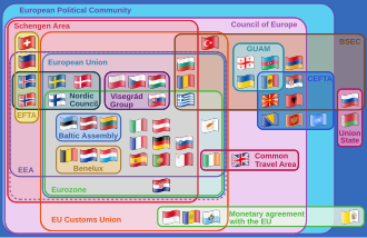

The political map of Europe is substantially derived from the re-organisation of Europe following the Napoleonic Wars in 1815. The prevalent form of government in Europe is parliamentary democracy, in most cases in the form of republic; in 1815, the prevalent form of government was still the monarchy. Europe's remaining eleven monarchies[257] are constitutional.
European integration is the process of political, legal, economic (and in some cases social and cultural) integration of European states as it has been pursued by the powers sponsoring the Council of Europe since the end of the Second World War. The European Union has been the focus of economic integration on the continent since its foundation in 1993. More recently, the Eurasian Economic Union has been established as a counterpart comprising former Soviet states.
27 European states are members of the politico-economic European Union, 29 of the border-free Schengen Area and 21 of the monetary union Eurozone. Among the smaller European organisations are the Nordic Council, the Benelux, the Baltic Assembly, and the Visegrád Group.
The least democratic countries in Europe were Belarus, Russia and Turkey in 2025 according to the V-Dem Democracy indices.[256]
List of states and territories
This list includes all internationally recognised sovereign countries falling even partially under any common geographical or political definitions of Europe.
| * | = Member state of the EU[258] |
| Arms | Flag | Name | Area(km2) | Population | Which political community governs (in June 2026) | Populationdensity(per km2) | Capital | Name(s) in official language(s) |
|---|---|---|---|---|---|---|---|---|
 |  | Albania | 28,748 | 2,876,591 | socialists (Socialist Party of Albania) | 98.5 | Tirana | Shqipëria |
 |  | Andorra | 468 | 77,281 | conservatives (Democrats for Andorra) | 179.8 | Andorra la Vella | Andorra |
 |  | Armenia[j] | 29,743 | 2,924,816 | liberals (Civil Contract) | 101.5 | Yerevan | Հայաստան (Hayastan) |
 |  | Austria* | 83,858 | 8,823,054 | liberals and socialists (Austrian People's Party and Social Democratic Party of Austria) | 104 | Vienna | Österreich |
 |  | Azerbaijan[k] | 86,600 | 9,911,646 | conservatives (New Azerbaijan Party) | 113 | Baku | Azərbaycan |
 |  | Belarus | 207,560 | 9,504,700 | conservatives (Belaya Rus) | 45.8 | Minsk | Беларусь (Belaruś) |
 |  | Belgium* | 30,528 | 11,358,357 | 372.06 | Brussels | België/Belgique/Belgien | |
 |  | Bosnia and Herzegovina | 51,129 | 3,531,159 | socialists (Alliance of Independent Social Democrats) | 68.97 | Sarajevo | Bosna i Hercegovina/Боснa и Херцеговина |
 |  | Bulgaria* | 110,910 | 7,101,859 | 64.9 | Sofia | България (Bǎlgariya) | |
 |  | Croatia* | 56,594 | 3,871,833 | conservatives (Croatian Democratic Union) | 68.4 | Zagreb | Hrvatska |
 |  | Cyprus*[d] | 9,251 | 1,170,125 | 123.4 | Nicosia | Κύπρος (Kýpros)/Kıbrıs | |
 |  | Czech Republic* | 78,866 | 10,610,947 | conservatives (Action of Dissatisfied Citizens) | 134 | Prague | Česko |
 |  | Denmark* | 43,094 | 6,001,008 | socialists (Social Democrats) | 139.25 | Copenhagen | Danmark |
 |  | Estonia* | 45,226 | 1,328,439 | liberals (Estonian Reform Party) | 30.5 | Tallinn | Eesti |
 |  | Finland* | 338,455 | 5,509,717 | conservatives (National Coalition Party) | 16 | Helsinki | Suomi/Finland |
 | France*[g] | 547,030 | 67,348,000 | liberals (Together for the Republic Group) | 116 | Paris | France | |
 |  | Georgia[l] | 69,700 | 3,718,200 | 53.5 | Tbilisi | საქართველო (Sakartvelo) | |
 |  | Germany* | 357,168 | 82,800,000 | conservatives (Christian Democratic Union of Germany) | 232 | Berlin | Deutschland |
 |  | Greece* | 131,957 | 10,297,760 | 82 | Athens | Ελλάδα (Elláda) | |
 |  | Hungary* | 93,030 | 9,797,561 | liberals (Respect and Freedom Party) | 105.3 | Budapest | Magyarország |
 |  | Iceland | 103,000 | 350,710 | socialists (Social Democratic Alliance) | 3.2 | Reykjavík | Ísland |
 |  | Ireland* | 70,280 | 4,761,865 | conservatives (Fianna Fáil) | 67.7 | Dublin | Éire/Ireland |
 |  | Italy* | 301,338 | 58,968,501 | conservatives (Brothers of Italy) | 195.7 | Rome | Italia |
 |  | Kazakhstan[i] | 148,000 | 20,075,271 | conservatives (Amanat) | 7 | Astana | Қазақстан (Qazaqstan) |
 |  | Latvia* | 64,589 | 1,862,700 | conservatives (New Unity) | 29 | Riga | Latvija |
 |  | Liechtenstein | 160 | 38,111 | 227 | Vaduz | Liechtenstein | |
 |  | Lithuania* | 65,300 | 2,800,667 | socialists (Social Democratic Party of Lithuania) | 45.8 | Vilnius | Lietuva |
 |  | Luxembourg* | 2,586 | 602,005 | 233.7 | Luxembourg City | Lëtzebuerg/Luxemburg/Luxembourg | |
 |  | Malta* | 316 | 445,426 | 1,410 | Valletta | Malta | |
 |  | Moldova[a] | 33,846 | 3,434,547 | 101.5 | Chișinău | Moldova | |
 |  | Monaco | 2.020 | 38,400 | 18,713 | Monaco | Monaco | |
 |  | Montenegro | 13,812 | 642,550 | conservatives (For the Future of Montenegro, Democratic Montenegro) | 45.0 | Podgorica | Crna Gora/Црна Гора |
 |  | Netherlands*[h] | 41,543 | 17,271,990 | 414.9 | Amsterdam | Nederland | |
 |  | North Macedonia | 25,713 | 2,103,721 | 80.1 | Skopje | Северна Македонија (Severna Makedonija) | |
 |  | Norway | 385,203 | 5,295,619 | socialists (Labour Party) | 15.8 | Oslo | Norge/Noreg/Norga |
 |  | Poland* | 312,685 | 38,422,346 | liberals (Civic Coalition) | 123.5 | Warsaw | Polska |
 |  | Portugal*[e] | 92,212 | 10,379,537 | 115 | Lisbon | Portugal | |
 |  | Romania* | 238,397 | 18,999,642 | 84.4 | Bucharest | România | |
 |  | Russia[b] | 3,969,100 | 144,526,636 | conservatives (United Russia) | 8.4 | Moscow | Россия (Rossiya) |
 |  | San Marino | 61.2 | 33,285 | 520 | San Marino | San Marino | |
 |  | Serbia[f] | 88,361 | 7,040,272 | conservatives (Serbia Must Not Stop) | 91.1 | Belgrade | Srbija/Србија |
 |  | Slovakia* | 49,035 | 5,435,343 | socialists (Direction – Social Democracy) | 111.0 | Bratislava | Slovensko |
 |  | Slovenia* | 20,273 | 2,066,880 | conservatives (Slovenian Democratic Party) | 101.8 | Ljubljana | Slovenija |
 |  | Spain* | 505,990 | 49,442,844 | socialists (Spanish Socialist Workers' Party) | 97 | Madrid | España |
 |  | Sweden* | 450,295 | 10,151,588 | conservatives (Moderate Party) | 22.5 | Stockholm | Sverige |
 |  | Switzerland | 41,285 | 8,401,120 | 202 | Bern | Schweiz/Suisse/Svizzera/Svizra | |
 | Turkey[m] | 23,764 | 84,680,273 | 106.7 | Ankara | Türkiye | ||
 |  | Ukraine[s] | 603,628 | 42,418,235 | 73.8 | Kyiv | Україна (Ukraina) | |
 |  | United Kingdom[259] | 244,376 | 68,265,209 | socialists (Labour Party) | 281 | London | United Kingdom |
 |  | Vatican City | 0.44 | 1,000 | 2,272 | Vatican City | Città del Vaticano/Civitas Vaticana | |
| Total | 50 | 10,180,000[n] | 743,000,000[n] | 73 | ||||
Within the above-mentioned states are several de facto independent countries with limited to no international recognition. None of them are members of the UN:
| Symbol | Flag | Name | Area(km2) | Population | Population density(per km2) | Capital |
|---|---|---|---|---|---|---|
 |  | Abkhazia[p] | 8,660 | 243,206 | 28 | Sokhumi |
 |  | Kosovo[o] | 10,908 | 1,920,079 | 159 | Pristina |
 |  | Northern Cyprus[d] | 3,355 | 313,626 | 93 | Nicosia (northern part) |
 |  | South Ossetia[p] | 3,900 | 53,532 | 13.7 | Tskhinvali |
 |  | Transnistria[a] | 4,163 | 475,665 | 114 | Tiraspol |
Several dependencies and similar territories with broad autonomy are also found within or close to Europe. This includes Åland (an autonomous county of Finland), two autonomous territories of the Kingdom of Denmark (other than Denmark proper), three Crown Dependencies and two British Overseas Territories. Svalbard is also included due to its unique status within Norway, although it is not autonomous. Not included are the three countries of the United Kingdom with devolved powers and the two Autonomous Regions of Portugal, which despite having a unique degree of autonomy, are not largely self-governing in matters other than international affairs. Areas with little more than a unique tax status, such as the Canary Islands and Heligoland, are also not included for this reason.
| * | = Part of the EU |
| Symbol | Flag | Name | Sovereignstate | Area(km2) | Population | Populationdensity(per km2) | Capital |
|---|---|---|---|---|---|---|---|
| Akrotiri and Dhekelia | UK | 255 | 7,700 | 30.2 | Episkopi Cantonment | |
 |  | Åland* | Finland | 1,580 | 29,489 | 18.36 | Mariehamn |
 |  | Bailiwick of Guernsey[c] | UK | 78 | 65,849 | 844.0 | St. Peter Port |
 |  | Bailiwick of Jersey[c] | UK | 118.2 | 100,080 | 819 | Saint Helier |
 |  | Faroe Islands | Denmark | 1,399 | 50,778 | 35.2 | Tórshavn |
 |  | Gibraltar | UK | 6.7 | 32,194 | 4,328 | Gibraltar |
 |  | Greenland | Denmark[r] | 2,166,086 | 55,877 | 0.028 | Nuuk |
 |  | Isle of Man[c] | UK | 572 | 83,314 | 148 | Douglas |
| Svalbard | Norway | 61,022 | 2,667 | 0.044 | Longyearbyen |
Economy

|
As a continent, the economy of Europe is currently the largest on Earth and it is the richest region as measured by assets under management with over $32.7 trillion compared to North America's $27.1 trillion in 2008.[260] In 2009 Europe remained the wealthiest region. Its $37.1 trillion in assets under management represented one-third of the world's wealth. It was one of several regions where wealth surpassed its precrisis year-end peak.[261] As with other continents, Europe has a large wealth gap among its countries. The richer states tend to be in the Northwest and West in general, followed by Central Europe, while most economies of Eastern and Southeastern Europe are still reemerging from the collapse of the Soviet Union and the breakup of Yugoslavia.
The model of the Blue Banana was designed as an economic geographic representation of the respective economic power of the regions, which was further developed into the Golden Banana or Blue Star. The trade between East and West, as well as towards Asia, which had been disrupted for a long time by the two world wars, new borders and the Cold War, increased sharply after 1989. In addition, there is new impetus from the Chinese Belt and Road Initiative across the Suez Canal towards Africa and Asia.[262]
The European Union, a political entity composed of 27 European states, comprises the largest single economic area in the world. 21 EU countries share the euro as a common currency (in addition, 6 non-EU countries also use the euro as currency). Four European countries rank in the top ten of the world's largest national economies in GDP (PPP). This includes (ranks according to the IMF): Russia (4), Germany (6), France (9) and the United Kingdom (10).
Some European countries are much richer than others. The richest in terms of nominal GDP is Monaco with its US$185,829 per capita (2018) and the poorest is Ukraine with its US$3,659 per capita (2019).[263]
As a whole, Europe's GDP per capita is US$21,767 according to a 2016 International Monetary Fund assessment.[264]
| Rank | Country | GDP(nominal, peak year)millions of USD |
|---|---|---|
 European Union[265] | 23,034,637 | |
| 1 | Germany | 5,452,858 |
| 2 | United Kingdom | 4,264,794 |
| 3 | France | 3,596,094 |
| 4 | Italy | 2,738,164 |
| 5 | Russia | 2,656,452 |
| 6 | Spanien | 2.091.222 |
| 7 | Truthahn | 1.640.223 |
| 8 | Niederlande | 1.449.704 |
| 9 | Schweiz | 1.146.911 |
| 10 | Polen | 1.134.248 |
| Rang | Land | BIP (Kaufkraftparität, Spitzenjahr) in Millionen USD |
|---|---|---|
| Europäische Union [ 265 ] | 30.677.594 | |
| 1 | Russland | 7.525.159 |
| 2 | Deutschland | 6.408.420 |
| 3 | Frankreich | 4.734.241 |
| 4 | Vereinigtes Königreich | 4.720.863 |
| 5 | Truthahn | 4.025.249 |
| 6 | Italien | 3.871.906 |
| 7 | Spanien | 2.977.960 |
| 8 | Polen | 2.164.271 |
| 9 | Niederlande | 1.592.206 |
| 10 | Rumänien | 950.384 |
Wirtschaftsgeschichte
- Industrielles Wachstum (1760–1945)
Der Kapitalismus ist seit dem Ende des Feudalismus in der westlichen Welt vorherrschend. [ 266 ] Von Großbritannien aus breitete er sich allmählich in ganz Europa aus. [ 267 ] Die Industrielle Revolution begann im späten 18. Jahrhundert in Europa, genauer gesagt im Vereinigten Königreich. [ 268 ] Im 19. Jahrhundert industrialisierte sich Westeuropa. Die Wirtschaft wurde durch den Ersten Weltkrieg stark beeinträchtigt, hatte sich aber zu Beginn des Zweiten Weltkriegs erholt und musste sich dem wachsenden wirtschaftlichen Aufschwung der Vereinigten Staaten stellen. Der Zweite Weltkrieg schädigte erneut einen Großteil der europäischen Industrie.
- Kalter Krieg (1945–1991)


Nach dem Zweiten Weltkrieg lag die Wirtschaft Großbritanniens am Boden [ 269 ] und erlitt in den folgenden Jahrzehnten weiterhin einen relativen wirtschaftlichen Niedergang. [ 270 ] Auch Italien befand sich in einer schwierigen wirtschaftlichen Lage, erreichte aber bis in die 1950er Jahre wieder ein hohes Wachstumsniveau. Westdeutschland erholte sich rasch und hatte seine Produktion bis in die 1950er Jahre gegenüber dem Vorkriegsniveau verdoppelt. [ 271 ] Frankreich erlebte ebenfalls ein bemerkenswertes Comeback mit rasantem Wachstum und Modernisierung; später erholte sich auch Spanien unter Francos Führung und verzeichnete ab den 1960er Jahren ein beispielloses Wirtschaftswachstum, das als spanisches Wirtschaftswunder bekannt wurde . [ 272 ] Die meisten mittel- und osteuropäischen Staaten gerieten unter die Kontrolle der Sowjetunion und waren somit Mitglieder des Rates für gegenseitige Wirtschaftshilfe (RGW). [ 273 ]
The states which retained a free-market system were given a large amount of aid by the United States under the Marshall Plan.[274] The western states moved to link their economies together, providing the basis for the EU and increasing cross border trade. This helped them to enjoy rapidly improving economies, while those states in COMECON were struggling in a large part due to the cost of the Cold War. Until 1990, the European Community was expanded from 6 founding members to 12. The emphasis placed on resurrecting the West German economy led to it overtaking the UK as Europe's largest economy.
- Reunification (1991–present)

With the fall of communism in Central and Eastern Europe in 1991, the post-socialist states underwent shock therapy measures to liberalise their economies and implement free market reforms.
After East and West Germany were reunited in 1990, the economy of West Germany struggled as it had to support and largely rebuild the infrastructure of East Germany, while the latter experienced sudden mass unemployment and plummeting of industrial production.
By the millennium change, the EU dominated the economy of Europe, comprising the five largest European economies of the time: Germany, the United Kingdom, France, Italy, and Spain. In 1999, 12 of the 15 members of the EU joined the Eurozone, replacing their national currencies by the euro.
Figures released by Eurostat in 2009 confirmed that the Eurozone had gone into recession in 2008.[276] It affected much of the region.[277] The Euro area crisis especially affected Greece, Ireland, Spain and Portugal.[278][279] As a result, measures were taken, especially for Greece, by the leading countries of the Eurozone.[280] The European Union unemployment rate was 10.3% in 2012. For those aged 15–24 it was 22.4%.[281]
Demographics

The population of Europe was about 742 million in 2023 according to UN estimates.[1][2] This is slightly more than one ninth of the world's population.[v] The population density of Europe (the number of people per area) is the second highest of any continent, behind Asia. The population of Europe is currently slowly decreasing, by about 0.2% per year,[283] because there are fewer births than deaths. This natural decrease in population is reduced by the fact that more people migrate to Europe from other continents than vice versa.
Southern Europe and Western Europe are the regions with the highest average number of elderly people in the world. In 2021, the percentage of people over 65 years old was 21% in Western Europe and Southern Europe, compared to 19% in all of Europe and 10% in the world.[284] Projections suggest that by 2050 Europe will reach 30%.[285] This is caused by the fact that the population has been having children below replacement level since the 1970s. The United Nations predicts that Europe will decline in population between 2022 and 2050 by −7 per cent, without changing immigration movements.[286]
According to a population projection of the UN Population Division, Europe's population may fall to between 680 and 720 million people by 2050, which would be 7% of the world population at that time.[287] Within this context, significant disparities exist between regions in relation to fertility rates. The average number of children per female of child-bearing age is 1.52, far below the replacement rate.[288] The UN predicts a steady population decline in Central and Eastern Europe as a result of emigration and low birth rates.[289]
Ethnic groups
Pan and Pfeil (2004) count 87 distinct "peoples of Europe", of which 33 form the majority population in at least one sovereign state, while the remaining 54 constitute ethnic minorities.[290]Romani people are the largest ethnic minority in Europe, according to European Commission.[291]
Migration
Europa beherbergte 2020 mit fast 87 Millionen Menschen die höchste Anzahl an Migranten weltweit, wie die Internationale Organisation für Migration (IOM) mitteilte . [ 292 ] Im Jahr 2005 verzeichnete die EU einen Nettozuwachs an Zuwanderern von 1,8 Millionen Menschen. Dies entsprach fast 85 % des gesamten Bevölkerungswachstums in Europa . [ 293 ] Im Jahr 2021 erhielten 827.000 Personen die Staatsbürgerschaft eines EU-Mitgliedstaates, ein Anstieg von etwa 14 % gegenüber 2020. [ 294 ] 2,3 Millionen Einwanderer aus Nicht-EU-Ländern kamen 2021 in die EU. [ 294 ]
Die frühneuzeitliche Auswanderung aus Europa begann im 16. Jahrhundert mit spanischen und portugiesischen Siedlern [ 295 ] [ 296 ] und im 17. Jahrhundert mit französischen und englischen Siedlern [ 297 ] . Die Zahlen blieben jedoch relativ gering, bis im 19. Jahrhundert Massenauswanderungswellen einsetzten, in deren Folge Millionen armer Familien Europa verließen [ 298 ] .
Heute gibt es auf allen Kontinenten große Bevölkerungsgruppen europäischer Abstammung . Europäische Vorfahren sind in Nordamerika vorherrschend und in geringerem Maße in Südamerika (insbesondere in Uruguay , Argentinien , Chile und Brasilien , während die meisten anderen lateinamerikanischen Länder ebenfalls eine beträchtliche Bevölkerung europäischer Herkunft aufweisen ). Australien und Neuseeland haben große Bevölkerungsgruppen europäischer Abstammung. In Afrika gibt es keine Länder mit einer Mehrheit europäischer Abstammung (mit Ausnahme von Kap Verde und möglicherweise São Tomé und Príncipe , je nach Kontext), aber es gibt bedeutende Minderheiten, wie beispielsweise die weißen Südafrikaner in Südafrika . In Asien sind Bevölkerungsgruppen europäischer Abstammung, insbesondere Russen , in Nordasien und Teilen Nordkasachstans vorherrschend . [ 299 ] Ebenfalls in Asien stellen Europäer, insbesondere Spanier, eine einflussreiche Minderheit auf den Philippinen dar . [ 300 ] [ 301 ]
Sprachen

Europe has about 225 indigenous languages,[302] mostly falling within three Indo-European language groups: the Romance languages, derived from the Latin of the Roman Empire; the Germanic languages, whose ancestor language came from southern Scandinavia; and the Slavic languages.[248] Slavic languages are mostly spoken in Southern, Central and Eastern Europe. Romance languages are spoken primarily in Western and Southern Europe, as well as in Switzerland in Central Europe and Romania and Moldova in Eastern Europe. Germanic languages are spoken in Western, Northern and Central Europe as well as in Gibraltar and Malta in Southern Europe.[248] Languages in adjacent areas show significant overlaps (such as in English, for example). Other Indo-European languages outside the three main groups include the Baltic group (Latvian and Lithuanian), the Celtic group (Irish, Scottish Gaelic, Manx, Welsh, Cornish and Breton[248]), Greek, Armenian and Albanian.
Eine eigenständige, nicht-indogermanische Familie uralischer Sprachen ( Estnisch , Finnisch , Ungarisch , Erzya , Komi , Mari , Moksha und Udmurtisch ) wird hauptsächlich in Estland , Finnland , Ungarn und Teilen Russlands gesprochen. Zu den Turksprachen gehören Aserbaidschanisch , Kasachisch und Türkisch sowie kleinere Sprachen in Ost- und Südosteuropa ( Balkan-Gagaustisch , Baschkirisch , Tschuwaschisch , Krimtatarisch , Karatschai-Balkarisch , Kumykisch , Nogaisch und Tatarisch ). Kartwelische Sprachen ( Georgisch , Mingrelisch und Swanisch ) werden vorwiegend in Georgien gesprochen . Zwei weitere Sprachfamilien sind im Nordkaukasus beheimatet ( Nordostkaukasisch , insbesondere Tschetschenisch , Awarisch und Lesgisch ; und Nordwestkaukasisch , insbesondere Adygeisch ). Maltesisch ist die einzige semitische Sprache , die innerhalb der EU Amtssprache ist, während Baskisch die einzige europäische isolierte Sprache ist .
Mehrsprachigkeit und der Schutz regionaler und Minderheitensprachen sind heute in Europa anerkannte politische Ziele. Das Rahmenübereinkommen des Europarats zum Schutz nationaler Minderheiten und die Europäische Charta der Regional- und Minderheitensprachen des Europarats bilden den rechtlichen Rahmen für Sprachrechte in Europa.
Romani wird in ganz Europa von der Roma-Minderheit gesprochen. [ 303 ]
Religion
- Christentum (76,2 %)
- Keine Religion (18,3 %)
- Islam (4,90 %)
- Buddhismus (0,20 %)
- Hinduismus (0,20 %)
- Volksreligion (0,10 %)
- Andere Religionen (0,10 %)
Die größte Religion in Europa ist das Christentum. 76,2 % der Europäer bezeichnen sich als Christen. [ 304 ] [ 305 ] Dazu gehören Katholiken , Orthodoxe und verschiedene protestantische Konfessionen. Unter den Protestanten sind Luthertum , Anglikanismus und Reformierte Kirche am weitesten verbreitet . Zu den kleineren protestantischen Konfessionen zählen die Täufer sowie in den Vereinigten Staaten beheimatete Strömungen wie Pfingstbewegung , Methodismus und Evangelikalismus . Obwohl das Christentum seinen Ursprung im Nahen Osten hat, verlagerte sich sein Zentrum nach Europa, als es im späten 4. Jahrhundert zur Staatsreligion des Römischen Reiches wurde . Das Christentum spielte eine bedeutende Rolle in der Entwicklung der europäischen Kultur und Identität . [ 306 ] [ 307 ] [ 308 ] Heute leben etwas mehr als 25 % der Christen weltweit in Europa. [ 309 ]
Der Islam ist die zweitgrößte Religion in Europa. Über 25 Millionen Menschen, also etwa 5 % der Bevölkerung, gehören ihm an. [ 310 ] In Albanien und Bosnien und Herzegowina , zwei Ländern auf der Balkanhalbinsel in Südosteuropa, ist der Islam die vorherrschende Religion. Dasselbe gilt für die Türkei und Teile Russlands sowie für Aserbaidschan und Kasachstan , die alle an Asien grenzen. [ 310 ] Viele europäische Länder beherbergen eine beträchtliche muslimische Minderheit, und die Zuwanderung nach Europa hat die Zahl der Muslime in den letzten Jahren erhöht.
The Jewish population in Europe was about 1.4 million people in 2020 (about 0.2% of the population).[311] There is a long history of Jewish life in Europe, beginning in antiquity. During the late 19th and early 20th centuries, the Russian Empire had the majority of the world's Jews living within its borders.[312] In 1897, according to Russian census of 1897, the total Jewish population of Russia was 5.1 million people, which was 4.13% of total population. Of this total, the vast majority lived within the Pale of Settlement.[313] In 1933, there were about 9.5 million Jewish people in Europe, representing 1.7% of the population,[314] but most were killed, and most of the rest displaced, during the Holocaust.[315][311] In the 21st century, France has the largest Jewish population in Europe, followed by the United Kingdom, Germany and Russia.[7]
Other religions practiced in Europe include Hinduism and Buddhism, which are minority religions, except in Russia's Republic of Kalmykia, where Tibetan Buddhism is the majority religion.
A large and increasing number of people in Europe are irreligious, atheist and agnostic. They are estimated to make up about 18.3% of Europe's population currently.[7]
Major cities and urban areas
The three largest urban areas of Europe are Moscow, London and Paris. All have over 10 million residents,[316] and as such have been described as megacities.[317] While Istanbul has the highest total city population, it lies partly in Asia. 64.9% of the residents live on the European side and 35.1% on the Asian side. The next largest cities in order of population are Madrid, Saint Petersburg, Milan, Barcelona, Berlin, and Rome each having over three million residents.[316]
When considering the commuter belts or metropolitan areas within Europe (for which comparable data is available), Moscow covers the largest population, followed in order by Istanbul, London, Paris, Madrid, Milan, Ruhr Area, Saint Petersburg, Rhein-Süd, Barcelona and Berlin.[318]
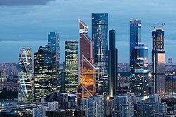


Culture
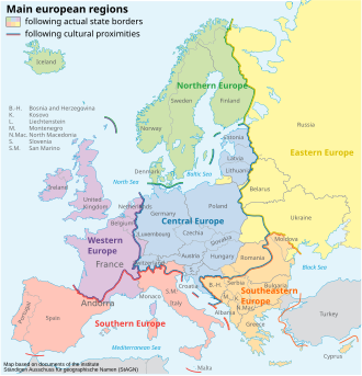
"Europe" as a cultural concept is substantially derived from the shared heritage of ancient Greece and the Roman Empire and its cultures. The boundaries of Europe were historically understood as those of Christendom (or more specifically Latin Christendom), as established or defended throughout the medieval and early modern history of Europe, especially against Islam, as in the Reconquista and the Ottoman wars in Europe.[319]
This shared cultural heritage is combined by overlapping indigenous national cultures and folklores, roughly divided into Slavic, Latin (Romance) and Germanic, but with several components not part of either of these groups (notably Greek, Basque and Celtic). Historically, special examples with overlapping cultures are Strasbourg with Latin (Romance) and Germanic, or Trieste with Latin, Slavic and Germanic roots. Cultural contacts and mixtures shape a large part of the regional cultures of Europe. Europe is often described as "maximum cultural diversity with minimal geographical distances".
Different cultural events are organised in Europe, with the aim of bringing different cultures closer together and raising awareness of their importance, such as the European Capital of Culture, the European Region of Gastronomy, the European Youth Capital and the European Capital of Sport.
Sport
Sport in Europe tends to be highly organised with many sports having professional leagues. The origins of many of the world's most popular sports today lie in the codification of many traditional games, especially in the United Kingdom. However, a paradoxical feature of European sport is the extent to which local, regional and national variations continue to exist, and even in some instances to predominate.[320]
Social dimension
In Europa haben viele Menschen keinen Zugang zu grundlegenden sozialen Bedingungen, was es ihnen erschwert, sich zu entfalten und ein gutes Leben zu führen. Der Zugang zu lebensnotwendigen Gütern kann beeinträchtigt sein; so geben beispielsweise 10 % der Europäer mindestens 40 % ihres Haushaltseinkommens für Wohnkosten aus. 75 Millionen Europäer fühlen sich sozial isoliert . Seit den 1980er Jahren nimmt die Einkommensungleichheit zu, während die Lohnanteile sinken. Im Jahr 2016 verdienten die reichsten 20 % der Haushalte mehr als fünfmal so viel wie die ärmsten 20 %. Viele Arbeitnehmer erleben stagnierende Reallöhne , und prekäre Beschäftigungsverhältnisse sind selbst für systemrelevante Berufe weit verbreitet . [ 321 ]
Siehe auch
- Frühneuzeitliches Europa
- Eurodistrikt – Europäische Verwaltungseinheit für binationale Städte
- Europäische Spiele – Europäisches Multisport-Event
- Die Europäische Union als potenzielle Supermacht
- Euroregion – Struktur der transnationalen Zusammenarbeit in der Europäischen Union
- Finanzielle und soziale Rangliste souveräner Staaten in Europa – Überblick über die finanzielle und soziale Rangliste der souveränen Staaten in Europa
- Flaggen Europas
- Gesundheitswesen in Europa – Europäisches Gesundheitswesen
- Liste der europäischen Fernsehsender
- Liste der Namen europäischer Städte in verschiedenen Sprachen
- Liste der souveränen Staaten Europas nach BIP (nominal)
- Liste der Dörfer in Europa
- Listen von Städten in Europa
- Moderne – Historische Epoche und soziokulturelle Norm oder Haltung
- Statistiken der OSZE-Länder
- Paneuropäische Identität – Persönliche Identifikation mit Europa
- Schienenverkehr in Europa
- Verkehr in Europa
Anmerkungen
- ^ a bTransnistrien wird international als rechtlich anerkannter Teil der Republik Moldau betrachtet , obwohl die faktische Kontrolle von seiner international nicht anerkannten Regierung ausgeübt wird, die 1990 ihre Unabhängigkeit von Moldau erklärte.
- ^Russland ist ein transkontinentales Land, das sich über Osteuropa und Nordasien erstreckt . Der Großteil seiner Bevölkerung (80 %) lebt im europäischen Teil . [ 322 ] Allerdings umfasst nur die Bevölkerungszahl das gesamte Staatsgebiet.
- ^ a b cGuernsey , die Isle of Man und Jersey sind Kronbesitzungen des Vereinigten Königreichs. Zu den weiteren Kanalinseln, die der Vogtei Guernsey unterstehen, gehören Alderney und Sark .
- ^ a bCyprus can be considered part of Europe or West Asia; it has strong historical and sociopolitical connections with Europe. The population and area figures refer to the entire state, including the de facto independent part Northern Cyprus which is not recognised as a sovereign nation by the vast majority of sovereign nations, nor the UN.
- ^
- ^
- ^Figures for France include only metropolitan France: some politically integral parts of France are geographically located outside Europe.
- ^Netherlands population for November 2014. Population and area details include European portion only: Netherlands and three entities outside Europe (Aruba, Curaçao, and Sint Maarten, in the Caribbean) constitute the Kingdom of the Netherlands. Amsterdam is the official capital, while The Hague is the administrative seat.
- ^Kazakhstan is physiographically considered a transcontinental country, mostly in Central Asia (UN region), partly in Eastern Europe, with European territory west of the Ural Mountains and Ural River. However, only the population figure refers to the entire country.
- ^
- ^Azerbaijan is physiographically considered a transcontinental country, mostly in Western Asia. A small portion of its territory is located north of Greater Caucasus, considered part of Eastern Europe.[323] However the population and area figures are for the entire state. This includes the exclave of the Nakhchivan Autonomous Republic and the region Nagorno-Karabakh.
- ^Georgien kann als Teil Osteuropas oder Westasiens betrachtet werden ; [ 323 ] es hat enge historische und soziopolitische Verbindungen zu Europa. [ 324 ] Die Bevölkerungs- und Flächenangaben beinhalten georgische Schätzungen für Abchasien und Südossetien , zwei Regionen, die ihre Unabhängigkeit erklärt und de facto erlangt haben . Die internationale Anerkennung ist jedoch begrenzt.
- ^Die Türkei gilt physiografisch als transkontinentales Land, das größtenteils in Westasien (dem Nahen Osten) liegt. Ein kleiner Teil des türkischen Territoriums (3 %), Ostthrakien genannt, befindet sich in Südosteuropa . [ 325 ] Allerdings umfasst nur die Bevölkerungszahl das gesamte Staatsgebiet.
- ^ a b c dDie Gesamtzahlen für Fläche und Bevölkerung umfassen nur die europäischen Anteile transkontinentaler Länder. Die Genauigkeit dieser Zahlen ist durch die uneindeutige geografische Ausdehnung Europas und das Fehlen von Referenzwerten für die europäischen Anteile transkontinentaler Länder beeinträchtigt.
- ^Kosovo erklärte am 17. Februar 2008 einseitig seine Unabhängigkeit von Serbien. Sein souveräner Status ist unklar . Die Bevölkerungszahl wurde im Juli 2009 von der CIA geschätzt.
- ^ a bAbchasien und Südossetien , die beide zu Osteuropa bzw. Westasien gezählt werden können [ 323 ], erklärten am 25. August 1990 bzw. 28. November 1991 einseitig ihre Unabhängigkeit von Georgien . Ihr Status als souveräne Staaten wird weder von der überwiegenden Mehrheit der souveränen Staaten noch von den Vereinten Nationen anerkannt . Die Bevölkerungszahlen basieren auf der Volkszählung von 2003 bzw. Schätzungen aus dem Jahr 2000.
- ^Bergkarabach , das zu Osteuropa oder Westasien gezählt werden kann , erklärte am 6. Januar 1992 einseitig seine Unabhängigkeit von Aserbaidschan. Sein Status als souveräner Staat wird weder von einem anderen souveränen Staat noch von den Vereinten Nationen anerkannt. Die Bevölkerungszahlen basieren auf der Volkszählung von 2003 bzw. Schätzungen aus dem Jahr 2000.
- ^Grönland , ein autonomes Land innerhalb des Königreichs Dänemark , ist geografisch Teil des nordamerikanischen Kontinents, wird aber politisch und kulturell mit Europa in Verbindung gebracht.
- ^ a bDie Volksrepublik Donezk und die Volksrepublik Luhansk werden international als völkerrechtlicher Teil der Ukraine anerkannt , obwohl die faktische Kontrolle von Regierungen ausgeübt wird, die 2014 ihre Unabhängigkeit von der Ukraine erklärten.
- ^Im englischsprachigen Raum, der das Sieben-Kontinente-Modell verwendet, wird Europa üblicherweise als eigener Kontinent betrachtet. [ 326 ] [ 327 ] Andere Modelle sehen Europa als Teil eines eurasischen oder afro-eurasischen Kontinents. Weitere Informationen finden Sie unter Kontinent § Nummer .
- ^Die Karte zeigt eine der gängigsten Darstellungen der geografischen Grenzen Europas, wie sie von National Geographic und der Encyclopædia Britannica verwendet wird . Die Zuordnung von Ländern zu Europa oder Asien kann je nach Quelle variieren, beispielsweise in der Klassifizierung des CIA World Factbook oder der BBC . Einige europäische Länder, wie etwa Frankreich, besitzen Gebiete, die geografisch außerhalb Europas liegen , aber dennoch als integraler Bestandteil des jeweiligen Landes gelten.
- ^Diese Zahl schließt Sibirien (etwa 38 Millionen Menschen) ein, schließt aber das europäische Teilgebiet der Türkei (etwa 12 Millionen) aus.
Referenzen
- ^ a b c „Weltbevölkerungsprognosen 2022“ . Abteilung für wirtschaftliche und soziale Angelegenheiten der Vereinten Nationen , Bevölkerungsabteilung . Abgerufen am 17. Juli 2022 .
- ^ a b c „Weltbevölkerungsprognosen 2022: Demografische Indikatoren nach Region, Subregion und Land, jährlich für 1950–2100“ (XSLX) („Gesamtbevölkerung, Stand 1. Juli (Tausend)“). Abteilung für Wirtschaftliche und Soziale Angelegenheiten der Vereinten Nationen , Bevölkerungsabteilung . Abgerufen am 17. Juli 2022 .
- ^ „BIP Kaufkraftparität, laufende Preise“ . Internationaler Währungsfonds. 2022. Archiviert vom Original am 22. Januar 2021. Abgerufen am 16. Januar 2022 .
- ^ „Nominales BIP zu laufenden Preisen“ . Internationaler Währungsfonds. 2022. Archiviert vom Original am 25. Februar 2017. Abgerufen am 16. Januar 2022 .
- ^ „Nominales BIP pro Kopf“ . Internationaler Währungsfonds. 2022. Archiviert vom Original am 11. Januar 2020. Abgerufen am 16. Januar 2022 .
- ^ „Berichte“ . Berichte zur menschlichen Entwicklung . Januar 2011. Archiviert vom Original am 9. Juli 2012. Abgerufen am 21. Juli 2017 .
- ^ a b c d e f g Analyse (19. Dezember 2011). „Globale Religionslandschaft“ (PDF) . Pewforum.org. Archiviert (PDF) vom Original am 23. März 2018. Abgerufen am 17. August 2012 .
- ^ „Demographia World Urban Areas“ (PDF) . Demographia. Archiviert (PDF) vom Original am 3. Mai 2018. Abgerufen am 28. Oktober 2020 .
- ^ „Europa“ . Encyclopædia Britannica . Archiviert vom Original am 30. März 2019. Abgerufen am 30. Juli 2022 .
- ^ „Europa: Humangeographie | National Geographic Society“ . education.nationalgeographic.org . Abgerufen am 4. Februar 2023 .
- ^ National Geographic Atlas der Welt (7. Aufl.). Washington, DC: National Geographic . 1999. ISBN 978-0-7922-7528-2Die„Europa“ (S. 68–69); „Asien“ (S. 90–91): „Eine allgemein anerkannte Trennlinie zwischen Asien und Europa ... wird gebildet durch das Uralgebirge, den Uralfluss, das Kaspische Meer, das Kaukasusgebirge und das Schwarze Meer mit seinen Mündungen, dem Bosporus und den Dardanellen.“
- ^ Lewis & Wigen 1997 , S. 226
- ^ Covert, Kim (2011). Das antike Griechenland: Wiege der Demokratie . Capstone. S. 5. ISBN 978-1-4296-6831-6Archiviert vom Original am 27. Juli 2022. Abgerufen am 30. Juli 2022. Das
antike Griechenland wird oft als Wiege der westlichen Zivilisation bezeichnet. … Ideen aus Literatur und Wissenschaft haben ebenfalls ihre Wurzeln im antiken Griechenland.
- ^ a b National Geographic, 534.
- ^ a b „Geschichte der Europäischen Union 1945–59“ . european-union.europa.eu . Archiviert vom Original am 23. April 2022. Abgerufen am 16. April 2022 .
- ^ „Die Europäische Union – eine Föderation oder ein Staatenbund?“ (PDF) . Archiviert (PDF) vom Original am 19. März 2022. Abgerufen am 30. Juli 2022 .
- ^ abM. L. West; West, Morris (2007). Indo-European Poetry and Myth. OUP Oxford. p. 185. ISBN 978-0-19-928075-9. Archived from the original on 22 January 2021. Retrieved 30 July 2022.
- ^FitzRoy, Charles (2015). The Rape of Europa: The Intriguing History of Titian's Masterpiece. Bloomsbury Publishing. pp. 52–. ISBN 978-1-4081-9211-5. Archived from the original on 20 March 2022. Retrieved 30 July 2022.
- ^Astour, Michael C. (1967). Hellenosemitica: An Ethnic and Cultural Study in West Semitic Impact on Mycenaean Greece. Brill Archive. p. 128. GGKEY:G19ZZ3TSL38. Archived from the original on 20 March 2022. Retrieved 30 July 2022.
- ^ ab"Europe – Origin and meaning of the name Europe by Online Etymology Dictionary". etymonline.com. Archived from the original on 17 September 2017. Retrieved 30 July 2022.
- ^ abBeekes, Robert (2004). "Kadmos and Europa, and the Phoenicians"(PDF). Kadmos. 43 (1): 168–69. doi:10.1515/kadm.43.1.167. ISSN 0022-7498. S2CID 162196643. Archived(PDF) from the original on 1 November 2021. Retrieved 30 July 2022.
- ^M. L. West (1997). The east face of Helicon: west Asiatic elements in Greek poetry and myth. Oxford: Clarendon Press. p. 451. ISBN 978-0-19-815221-7..
- ^Davidson, Roderic H. (1960). "Where is the Middle East?". Foreign Affairs. 38 (4): 665–675. doi:10.2307/20029452. JSTOR 20029452. S2CID 157454140.
- ^ ab"Europe". Microsoft Encarta Online Encyclopaedia 2007. Archived from the original on 28 October 2009. Retrieved 27 December 2007.
- ^"Cyprus". The World Factbook (2024 ed.). Central Intelligence Agency. Retrieved 13 August 2024.
- ^Falconer, William; Falconer, Thomas. Dissertation on St. Paul's VoyageArchived 2017-03-27 at the Wayback Machine, BiblioLife (BiblioBazaar), 1872. (1817.), p. 50, ISBN 1-113-68809-2These islands Pliny, as well as Strabo and Ptolemy, included in the African sea
- ^"Europe – Noun". Princeton University. Archived from the original on 15 July 2014. Retrieved 9 June 2008.
- ^Histories 4.38. Cf. James Rennell, The geographical system of Herodotus examined and explained, Volume 1, Rivington 1830, p. 244
- ^Herodotus, 4:45
- ^Strabo Geography 11.1
- ^Franxman, Thomas W. (1979). Genesis and the Jewish antiquities of Flavius Josephus. Pontificium Institutum Biblicum. pp. 101–102. ISBN 978-88-7653-335-8.
- ^W. Theiler, Posidonios. Die Fragmente, vol. 1. Berlin: De Gruyter, 1982, fragm. 47a.
- ^I. G. Kidd (ed.), Posidonius: The commentary, Cambridge University Press, 2004, ISBN 978-0-521-60443-7, p. 738Archived 1 August 2020 at the Wayback Machine.
- ^Geographia 7.5.6 (ed. Nobbe 1845, vol. 2Archived 24 May 2020 at the Wayback Machine, p. 178) Καὶ τῇ Εὐρώπῃ δὲ συνάπτει διὰ τοῦ μεταξὺ αὐχένος τῆς τε Μαιώτιδος λίμνης καὶ τοῦ Σαρματικοῦ Ὠκεανοῦ ἐπὶ τῆς διαβάσεως τοῦ Τανάϊδος ποταμοῦ. "And [Asia] is connected to Europe by the land-strait between Lake Maiotis and the Sarmatian Ocean where the river Tanais crosses through."
- ^ abJ. G. A. Pocock (2002). "Some Europes in Their History". In Pagden, Anthony (ed.). The Idea of Europe From Antiquity to the European Union. Cambridge University Press. pp. 57–61. doi:10.1017/CBO9780511496813.003. ISBN 978-0-511-49681-3. Archived from the original on 23 March 2022. Retrieved 30 July 2022.
- ^Norman F. Cantor, The Civilization of the Middle Ages, 1993, ""Culture and Society in the First Europe", pp185ff.
- ^Dawson, Christopher; Olsen, Glenn (2010) [1961]. Crisis in Western Education (reprint ed.). CUA Press. p. 108. ISBN 978-0-8132-1683-6.
- ^Noted by Cantor, 1993:181.
- ^J. G. A. Pocock. "Western historiography and the problem of "Western" history"(PDF). United Nations. pp. 5–6. Archived(PDF) from the original on 13 June 2022. Retrieved 30 July 2022.
- ^Philipp Johann von Strahlenberg (1730). Das Nord-und Ostliche Theil von Europa und Asia (in German). p. 106.
- ^Davies, Norman (1996). Europe: A History. Oxford University Press. p. 8. ISBN 978-0-19-820171-7. Archived from the original on 1 August 2020. Retrieved 23 August 2010.
- ^"Boundary of Europe and Asia along Urals" (in Russian). Archived from the original on 8 January 2012.
- ^Peter Simon Pallas, Journey through various provinces of the Russian Empire, vol. 3 (1773)
- ^Douglas W. Freshfield: "Journey in the Caucasus". Archived 2020-08-01 at the Wayback Machine". Proceedings of the Royal Geographical Society, volumes 13–14, 1869. Cited as de facto convention by Baron von Haxthausen, Transcaucasia (1854); review Dublin University Magazine.
- ^"Europe", Brockhaus and Efron Encyclopedic Dictionary, 1906
- ^"Do we live in Europe or in Asia?" (in Russian). Archived from the original on 18 February 2018. Retrieved 30 July 2022.
- ^Orlenok V. (1998). "Physical Geography" (in Russian). Archived from the original on 16 October 2011.
- ^Tutin, T.G.; Heywood, V.H.; Burges, N.A.; Valentine, D.H.; Walters, S.M.; Webb, D.A. (1990) [1964]. Flora Europaea, Volume 1: Lycopodiaceae to Platanaceae. Cambridge: Cambridge University Press. ISBN 978-0-521-06661-7.
- ^Tutin, Thomas Gaskell (1993). Flora Europaea, Volume 1: Psilotaceae to Platanaceae (2nd ed.). Cambridge, New York, Melbourne [etc.]: Cambridge University Press. ISBN 978-0-521-41007-6.
- ^E. M. Moores, R. W. Fairbridge, 1997 Encyclopedia of European and Asian Regional Geology, Springer, ISBN 978-0-412-74040-4, p. 34: "most Soviet geographers took the watershed of the Main Range of the Greater Caucasus as the boundary between Europe and Asia."
- ^Lewis & Wigen (1997), p. 9,10.
- ^ abPosth; Yu; Ghalichi (2023). "Palaeogenomics of Upper Palaeolithic to Neolithic European hunter-gatherers". Nature. 615 (2 March 2023): 117–126. Bibcode:2023Natur.615..117P. doi:10.1038/s41586-023-05726-0. PMC 9977688. PMID 36859578.
- ^"Quaternary Period". National Geographic. 6 January 2017. Archived from the original on 29 November 2020. Retrieved 30 July 2022.
- ^"How long can we expect the present Interglacial period to last?". U.S. Department of the Interior. Archived from the original on 26 July 2022. Retrieved 30 July 2022.
- ^A. Vekua; D. Lordkipanidze; G.P. Rightmire; J. Agusti; R. Ferring; G. Maisuradze; et al. (2002). "A new skull of early Homo from Dmanisi, Georgia". Science. 297 (5578): 85–89. Bibcode:2002Sci...297...85V. doi:10.1126/science.1072953. PMID 12098694. S2CID 32726786.
- ^The million year old tooth from . Archived 13 January 2018 at the Wayback Machine. Atapuerca, Spain, found in June 2007.
- ^Strickland, Ashley (10 October 2018). "Bones reveal Neanderthal child was eaten by a giant bird". CNN. Archived from the original on 7 July 2022. Retrieved 30 July 2022.
- ^"Neanderthals Died Out 10,000 Years Earlier Than Thought, With Help From Modern Humans". National Geographic. 21 August 2014. Archived from the original on 18 February 2021.
- ^National Geographic, 21.
- ^ Fleming, Nic (2022). „Meine Arbeit : Die Ausgrabung der Behausungen unserer Vorfahren“ . Nature . 606 (7916): 1035. Bibcode : 2022Natur.606.1035F . doi : 10.1038/d41586-022-01593-3 . PMID 35676354. S2CID 249520231 .
- ^ Fu, Qiaomei; et al. (23. Oktober 2014). „Die Genomsequenz eines 45.000 Jahre alten modernen Menschen aus Westsibirien“ . Nature . 514 ( 7523): 445–449 . Bibcode : 2014Natur.514..445F . doi : 10.1038/nature13810 . hdl : 10550/42071 . PMC 4753769. PMID 25341783 .
- ^ 42,7–41,5 ka ( 1σ CI ). Douka, Katerina; et al. (2012). „Ein neuer chronostratigraphischer Rahmen für das Jungpaläolithikum von Riparo Mochi (Italien)“. Zeitschrift für menschliche Evolution . 62 (2): 286–299 . Bibcode : 2012JHumE..62..286D . doi : 10.1016/j.jhevol.2011.11.009 . PMID 22189428 .
- ^ Borza, EN (1992). Im Schatten des Olymp: Die Entstehung Makedoniens . Princeton University Press. S. 58. ISBN 978-0-691-00880-6Archiviert vom Original am 1. August 2020. Abgerufen am 30. Juli 2022 .
- ^ Scarre, Chris (1996). Fagan, Brian M. (Hrsg.). The Oxford Companion to Archaeology . Oxford University Press . S. 215–216 . ISBN 978-0-19-507618-9Die
- ^ Atkinson, RJC , Stonehenge ( Penguin Books , 1956)
- ^ Peregrine, Peter Neal ; Ember, Melvin (Hrsg.) (2001). „Europäische Megalithkultur“. Enzyklopädie der Vorgeschichte . Band 4. Springer. S. 157–184 . ISBN 978-0-306-46258-0Die
- ^ abHaak, Wolfgang; Lazaridis, Iosif; Patterson, Nick; Rohland, Nadin; Mallick, Swapan; Llamas, Bastien; Brandt, Guido; Nordenfelt, Susanne; Harney, Eadaoin; Stewardson, Kristin; Fu, Qiaomei (11 June 2015). "Massive migration from the steppe was a source for Indo-European languages in Europe". Nature. 522 (7555): 207–211. arXiv:1502.02783. Bibcode:2015Natur.522..207H. doi:10.1038/nature14317. ISSN 0028-0836. PMC 5048219. PMID 25731166.
- ^"When the First Farmers Arrived in Europe, Inequality Evolved". Scientific American. 1 July 2020. Archived from the original on 25 May 2022. Retrieved 16 September 2022.
- ^Gibbons, Ann (21 February 2017). "Thousands of horsemen may have swept into Bronze Age Europe, transforming the local population". Science. Archived from the original on 25 September 2022. Retrieved 6 October 2022.
- ^"Ancient Greece". British Museum. Archived from the original on 15 June 2012.
- ^"Periods – School of Archaeology". University of Oxford. Archived from the original on 19 November 2018. Retrieved 25 December 2018.
- ^Short, John R. (1987). An Introduction to Urban Geography. Routledge. p. 10. ISBN 978-0-7102-0372-4. Archived from the original on 20 March 2022. Retrieved 30 July 2022.
- ^ abcDaly, Jonathan (2013). The Rise of Western Power: A Comparative History of Western Civilization. A&C Black. pp. 7–9. ISBN 978-1-4411-1851-6. Archived from the original on 28 April 2022. Retrieved 30 July 2022.
- ^Dunn, John (1994). Democracy: the unfinished journey 508 BCE – 1993 CE. Oxford University Press. ISBN 978-0-19-827934-1.
- ^National Geographic, 76.
- ^Heath, Thomas Little (1981). A History of Greek Mathematics, Volume I. Dover Publications. ISBN 978-0-486-24073-2.
- ^Heath, Thomas Little (1981). A History of Greek Mathematics, Volume II. Dover publications. ISBN 978-0-486-24074-9.
- ^Pedersen, Olaf. Early Physics and Astronomy: A Historical Introduction. 2nd edition. Cambridge: Cambridge University Press, 1993.
- ^Strauss, Barry (2005). The Battle of Salamis: The Naval Encounter That Saved Greece – and Western Civilization. Simon and Schuster. pp. 1–11. ISBN 978-0-7432-7453-1. Archived from the original on 23 June 2022. Retrieved 30 July 2022.
- ^ abMcEvedy, Colin (1961). The Penguin Atlas of Medieval History. Penguin Books.
- ^National Geographic, 123.
- ^Foster, Sally M., Picts, Gaels, and Scots: Early Historic Scotland. Batsford, London, 2004. ISBN 0-7134-8874-3
- ^Williams, Stephen; Friell, Gerard (2005). Theodosius: The Empire at Bay. Routledge. p. 105. ISBN 978-1-135-78262-7. Archived from the original on 30 May 2022. Retrieved 30 July 2022.
- ^Hadas, Moses (1950). A History of Greek Literature. Columbia University Press. pp. 273, 327. ISBN 0-231-01767-7. Archived from the original on 21 May 2022. Retrieved 30 July 2022.
{{cite book}}: ISBN / Date incompatibility (help) - ^Laiou & Morisson 2007, pp. 130–131; Pounds 1979, p. 124.
- ^Journal of the History of Ideas, Vol. 4, No. 1. (January 1943), pp. 69–74.
- ^Norman F. Cantor, The Medieval World 300 to 1300.
- ^National Geographic, 135.
- ^Hunter, Shireen; et al. (2004). Islam in Russia: The Politics of Identity and Security. M.E. Sharpe. p. 3.
(..) It is difficult to establish exactly when Islam first appeared in Russia because the lands that Islam penetrated early in its expansion were not part of Russia at the time, but were later incorporated into the expanding Russian Empire. Islam reached the Caucasus region in the middle of the seventh century as part of the Arab conquest of the Iranian Sassanian Empire.
- ^Kennedy, Hugh (1995). "The Muslims in Europe". In McKitterick, Rosamund, The New Cambridge Medieval History: c. 500 – c. 700, pp. 249–272. Cambridge University Press. 052136292X.
- ^National Geographic, 143–145.
- ^National Geographic, 162.
- ^National Geographic, 166.
- ^Bulliet et al. 2011, p. 250.
- ^Brown, Anatolios & Palmer 2009, p. 66.
- ^Gerald Mako, "The Islamization of the Volga Bulghars: A Question Reconsidered", Archivum Eurasiae Medii Aevi 18, 2011, 199–223.
- ^Marc'Antonio Bragadin, Storia delle Repubbliche marinare, Odoya, Bologna 2010, 240 pp., ISBN 978-88-6288-082-4
- ^G. Benvenuti, Le Repubbliche Marinare. Amalfi, Pisa, Genova, Venezia, Newton & Compton editori, Roma 1989
- ^ abNational Geographic, 158.
- ^National Geographic, 186.
- ^National Geographic, 192.
- ^National Geographic, 199.
- ^Laiou & Morisson 2007, pp. 130–131; Pounds 1979, p. 124.
- ^Duiker, William J.; Spielvogel, Jackson J. (2010). The Essential World History. Cengage Learning. p. 330. ISBN 978-0-495-90227-0. Archived from the original on 11 May 2013. Retrieved 20 January 2013.
The Byzantine Empire also interacted with the world of Islam to its east and the new European civilization of the west. Both interactions proved costly and ultimately fatal.
- ^Findlay, Ronald (2006). Eli Heckscher, International Trade, And Economic History. MIT Press. pp. 178–179. ISBN 978-0-262-06251-0. Archived from the original on 11 May 2013. Retrieved 20 January 2013.
These Christian allies did not accept the authority of Byzantium, and the Fourth Crusade that sacked Constantinople and established the so-called Latin Empire that lasted until 1261 was a fatal wound from which the empire never recovered until its fall at the hands of the Ottoman Turks in 1453 (Queller and Madden 1997).
- ^Browning, Robert (1992). The Byzantine Empire (Revised ed.). CUA Press. p. 253. ISBN 978-0-8132-0754-4. Retrieved 20 January 2013.
And though the final blow was struck by the Ottoman Turks, it can plausibly be argued that the fatal injury was inflicted by the Latin crusaders in 1204.
- ^Byfield, Ted (2008). A Glorious Disaster: A.D. 1100 to 1300: The Crusades: Blood, Valor, Iniquity, Reason, Faith. Christian History Project. p. 136. ISBN 978-0-9689873-7-7Archiviert vom Original am 11. Mai 2013. Abgerufen am 20. Januar 2013.
Die Stadt hielt noch weitere 250 Jahre stand, bevor sie schließlich an die muslimischen Türken fiel, war aber durch den Vierten Kreuzzug unwiderruflich geschwächt
worden . - ^ Golna, Cornelia (2004). City of Man's Desire: A Novel of Constantinople . Go-Bos Press. S. 424. ISBN 978-90-804114-4-9Archiviert vom Original am 11. Mai 2013. Abgerufen am 20. Januar 2013. 1204
Der Vierte Kreuzzug plündert Konstantinopel, zerstört und raubt viele seiner Schätze und schwächt das Reich dadurch wirtschaftlich und militärisch fatal
. - ^ Powell, John (2001). Magills Leitfaden zur Militärgeschichte: A-Cor . Salem Press. ISBN 978-0-89356-015-7Archiviert vom Original am 11. Mai 2013. Abgerufen am 20. Januar 2013. Die darauffolgenden 57 Jahre der Plünderungen schwächten das Byzantinische Reich jedoch nachhaltig, selbst nach der Rückeroberung der
Hauptstadt im Jahr 1261. Ab 1222 wurde das Reich durch einen Bürgerkrieg, der bis 1355 andauerte, weiter geschwächt. … Als die Osmanen 1453 ihre Gebiete überrannten und Konstantinopel belagerten, waren bittere Armut und Schwäche die Ursachen für den endgültigen Fall der Hauptstadt.
- ^ Irvin, Dale T. (2002). Geschichte der weltweiten christlichen Bewegung: Band 1: Frühes Christentum bis 1453. Continuum International Publishing Group. S. 405. ISBN 978-0-567-08866-6Archiviert vom Original am 11. Mai 2013. Abgerufen am 20. Januar 2013. Der Vierte Kreuzzug verschärfte nicht nur den Groll der griechischsprachigen Christen gegenüber dem lateinischen Westen, sondern schwächte auch das Reich von
Konstantinopel weiter, viele sagen sogar fatal. Nach der Restauration der griechischen Herrschaft blieb die Stadt zwar noch zwei Jahrhunderte lang Hauptstadt von Byzanz, erholte sich aber nie vollständig.
- ^ Frucht, Richard C. (2004). Osteuropa: Eine Einführung in die Menschen, Länder und Kulturen . ABC-CLIO. S. 856. ISBN 978-1-57607-800-6Archiviert vom Original am 11. Mai 2013. Abgerufen am 20. Januar 2013. Obwohl das Reich wiedererstarkt wurde, hatten die Ereignisse von 1204 Byzanz so sehr
geschwächt, dass es keine Großmacht mehr war.
- ^ Duiker, William J.; Spielvogel, Jackson J. (2010). Die Essenz der Weltgeschichte . Cengage Learning. S. 386. ISBN 978-0-495-90227-0Archiviert vom Original am 11. Mai 2013. Abgerufen am 20. Januar 2013. Später etablierten sie sich auf der anatolischen Halbinsel auf Kosten des Byzantinischen Reiches .
… Die Byzantiner waren jedoch durch die Plünderung Konstantinopels im Vierten Kreuzzug (1204) und die westliche Besetzung großer Teile des Reiches für das folgende halbe Jahrhundert stark geschwächt.
- ^ National Geographic, 211.
- ^ Peters, Ralph (2006). Neuer Ruhm: Amerikas globale Vorherrschaft ausbauen . Sentinel. ISBN 978-1-59523-030-0Abgerufen am 20. Januar 2013. Es waren westliche Christen, nicht Muslime, die
die byzantinische Macht entscheidend schwächten und dem Islam den Weg in den Westen ebneten.
- ^ Chroniken . Rockford Institute. 2005. Archiviert vom Original am 11. Mai 2013. Abgerufen am 20. Januar 2013.
Zweieinhalb Jahrhunderte brauchten Byzanz, um sich vom Vierten Kreuzzug zu erholen, bevor die Osmanen 1453 schließlich Konstantinopel einnahmen. Sie verwundeten Byzanz tödlich, was die Hauptursache für seinen geschwächten Zustand beim muslimischen Ansturm war. Selbst am Vorabend seines endgültigen Zusammenbruchs war die Unterwerfung Florenz' Voraussetzung für jegliche westliche Hilfe
. - ^ Kljutschewski, Wassili (1987). Der Verlauf der russischen Geschichte . "Myslʹ. ISBN 978-5-244-00072-6Archiviert vom Original am 24. Oktober 2007. Abgerufen am 30. Juli 2022 .
- ^ Lane, George (25. Januar 2018). Eine kurze Geschichte der Mongolen . Bloomsbury Publishing. S. 11. ISBN 978-1-78672-339-0Die
- ^ Fennell, John (13. Oktober 2014) [1983]. Die Krise des mittelalterlichen Russlands 1200–1304 . Routledge. S. 84. ISBN 978-1-317-87314-3Die
- ^ Favereau, Marie (20. April 2021). Die Horde: Wie die Mongolen die Welt veränderten . Harvard University Press. S. 300. ISBN 978-0-674-24421-4Die
- ^ Spinei, Victor. Die Rumänen und die turkischen Nomaden nördlich des Donaudeltas vom 10. bis zur Mitte des 13. Jahrhunderts, Brill, 2009, ISBN 978-90-04-17536-5
- ^ Wright, Thomas Edmund Farnsworth (2015). A Dictionary of World History . Oxford University Press. S. 574. ISBN 978-0-19-968569-1Die
- ^ a b Dukes, Paul (1998). Geschichte Russlands: Mittelalter, Neuzeit, Gegenwart, ca. 882–1996 . Duke University Press. S. 42–45 . ISBN 978-0-8223-2096-8Die
- ^ Das späte Mittelalter. Archiviert am 2. November 2015 in der Wayback Machine . Oglethorpe University.
- ^ Baumgartner, Frederic J. Frankreich im 16. Jahrhundert. London: Macmillan Publishers , 1995. ISBN 0-333-62088-7Die
- ^ Don O'Reilly. „ Der Hundertjährige Krieg: Jeanne d’Arc und die Belagerung von Orléans “. TheHistoryNet.com . Archiviert am 9. November 2006 im Internet Archive.
- Schlechte Studienleistungen werden uns immer begleiten . Von James Bartholomew. Telegraph. 7. August 2004.
- ^ Hungersnot ( Archiviert am 7. Mai 2015 in der Wayback Machine) . Encyclopædia Britannica.
- ^ „Die Pest: Der Schwarze Tod“ . National Geographic . Archiviert vom Original am 16. Februar 2012. Abgerufen am 1. April 2012 .
- ^ National Geographic, 223.
- ^ „Epidemien der Vergangenheit: Die Beulenpest“ . Infoplease.com. Archiviert vom Original am 21. Oktober 2008. Abgerufen am 3. November 2008 .
- ^ Revill, Jo (16. Mai 2004). „Schwarzer Tod wird dem Menschen und nicht Ratten angelastet | Nachrichten aus Großbritannien | The Observer“ . The Observer . London. Archiviert vom Original am 12. Februar 2014. Abgerufen am 3. November 2008 .
- ^ a b Peter Barrett (2004), Science and Theology Since Copernicus: The Search for Understanding (Archiviert am 22. April 2022 in der Wayback Machine ), S. 14–18, Continuum, ISBN 0-567-08969-X
- ^ Weiss, Roberto (1969) Die Renaissance-Entdeckung der klassischen Antike , ISBN 1-59740-150-1
- ^ Burckhardt, Jacob (1990) [1878]. Die Kultur der Renaissance in Italien . Übersetzt von Middlemore, SGC. London: Penguin. ISBN 978-0-14-044534-3Die
- ^ National Geographic, 254.
- ^ Jensen, De Lamar (1992), Europa der Renaissance , ISBN 0-395-88947-2
- ^ Levey, Michael (1967). Frühe Renaissance . Penguin Books.
- ^ National Geographic, 292.
- ^ Levey, Michael (1971). Hochrenaissance . Penguin.
- ^ National Geographic, 193.
- ^ Roberts, John Morris (1997). Penguin History of Europe . Penguin. ISBN 978-0-14-026561-3Die
- ^National Geographic, 296.
- ^National Geographic, 338.
- ^Elliott p. 333
- ^Morris, Terence Alan (1998). Europe and England in the sixteenth century. Routledge, p. 335. ISBN 0-415-15041-8
- ^Rowse, A. L. (1969). Tudor Cornwall: portrait of a society. C. Scribner, p. 400
- ^"One decisive action might have forced Philip II to the negotiating table and avoided fourteen years of continuing warfare. Instead the King was able to use the brief respite to rebuild his naval forces and by the end of 1589 Spain once again had an Atlantic fleet strong enough to escort the American treasure ships home." The Mariner's Mirror, Volumes 76–77. Society for Nautical Research., 1990
- ^Kamen, Henry. Spain's Road to Empire: The Making of a World Power, 1492–1763. p. 221.
- ^National Geographic, 256–257.
- ^"European History/Religious Wars in Europe – Wikibooks, open books for an open world". en.wikibooks.org. Archived from the original on 31 May 2022. Retrieved 30 July 2022.
- ^Humphreys, Kenneth. Jesus Never Existed: An Introduction to the Ultimate Heresy.
- ^History of Europe – DemographicsArchived 1 January 2015 at the Wayback Machine. Encyclopædia Britannica.
- ^National Geographic, 269.
- ^Virginia Aksan, Ottoman Wars, 1700–1860: An Empire Besieged, (Pearson Education Limited, 2007), 28.
- ^"The Seventeenth-Century Decline". The Library of Iberian resources online. Archived from the original on 27 March 2017. Retrieved 13 August 2008.
- ^"Food, Famine And FertilisersArchived 2022-04-17 at the Wayback Machine". Seshadri Kannan (2009). APH Publishing. p. 51. ISBN 81-313-0356-X
- ^Frost, Robert I. (2004). After the Deluge; Poland-Lithuania and the Second Northern War, 1655–1660. Cambridge University Press. ISBN 978-0-521-54402-3. Retrieved 30 July 2022.
- ^Lukowski, Jerzy (2014). The Partitions of Poland 1772, 1793, 1795. New York: Routledge. ISBN 978-1-317-88694-5. Retrieved 30 July 2022.
- ^ WG Clarence-Smith (2006). „ Islam und die Abschaffung der Sklaverei “. Archiviert am 29.04.2016 in der Wayback Machine . Oxford University Press. S. 13. ISBN 0-19-522151-6 – „Die Gebiete nördlich des Schwarzen Meeres lieferten den Osmanen ab 1450 wahrscheinlich die meisten Sklaven. Eine Zusammenstellung von Schätzungen geht davon aus, dass die Krimtataren zwischen 1468 und 1694 etwa 1.750.000 Ukrainer, Polen und Russen verschleppten.“
- ^ Hunt, Shelby D. (2003). Kontroverse in der Marketingtheorie: Für Vernunft, Realismus, Wahrheit und Objektivität . ME Sharpe. S. 18. ISBN 978-0-7656-0932-8Abgerufen am 30. Juli 2022 .
- ^ Hatch, Robert A. „Wissenschaftliche Revolution: Chronologische Zeitleiste: Von Kopernikus bis Newton“ . Archiviert vom Original am 23. Juli 2013. Abgerufen am 24. März 2023 .
- ^ Gipson, Lawrence Henry (1950). „Die Amerikanische Revolution als Folge des Ersten Weltkriegs, 1754–1763“. Political Science Quarterly . 65 (1): 86–104 . doi : 10.2307/2144276 . JSTOR 2144276 .
- ^ Goldie, Mark; Wokler, Robert (2006). The Cambridge History of Eighteenth-Century Political Thought . Cambridge University Press. ISBN 978-0-521-37422-4Die
- ^ Cassirer, Ernst (1979). Die Philosophie der Aufklärung . Princeton University Press. ISBN 978-0-691-01963-5Die
- ^ National Geographic, 255.
- ^ Schama, Simon (1989). Bürger: Eine Chronik der Französischen Revolution . Knopf . ISBN 978-0-394-55948-3Die
- ^ National Geographic, 360.
- ^ McEvedy, Colin (1972). Der Penguin-Atlas der modernen Geschichte . Penguin Books. ISBN 978-0-14-051153-6Die
- ^ Lyons, Martyn (1994). Napoleon Bonaparte und das Erbe der Französischen Revolution . St. Martin's Press . ISBN 978-0-312-12123-5Die
- ^ Grab, Alexander (2003). Napoleon und die Transformation Europas (Europäische Geschichte in der Perspektive) . Palgrave Macmillan. ISBN 978-0-333-68275-3Die
- ^ National Geographic, 350.
- ^ National Geographic, 367.
- ^ National Geographic, 371–373.
- ^ Davies, Norman (1996). Europa: Eine Geschichte . Oxford University Press. ISBN 978-0-19-820171-7Die
- ^[1]. Archived 26 January 2022 at the Wayback Machine. Ottoman Empire – 19th century. Historyworld.
- ^Trevelyan, George Macaulay (1988). A shortened history of England. Penguin Books. ISBN 978-0-14-010241-3.
- ^Webb, Sidney (1976). History of Trade Unionism. AMS Press. ISBN 978-0-404-06885-1.
- ^SlaveryArchived 16 October 2014 at the Wayback Machine, Historical survey – Ways of ending slavery, Encyclopædia Britannica
- ^Trevelyan, George Macaulay (1942). English Social History. Longmans, Green.
- ^Modernisation – Population ChangeArchived 30 July 2022 at the Wayback Machine. Encyclopædia Britannica.
- ^"The Irish FamineArchived 2019-11-09 at the Wayback Machine". BBC – History.
- ^The Atlantic: Can the US afford immigration?Archived 4 July 2010 at the Wayback Machine. Migration News. December 1996.
- ^Maddison (27 July 2016). "Growth of World Population, GDP and GDP Per Capita before 1820"(PDF). University of Groningen. Archived from the original(PDF) on 12 February 2021. Retrieved 12 June 2024.
- ^World Population Growth, 1950–2050. Population Reference Bureau. Archived 22 July 2013 at the Wayback Machine
- ^"Assassin Gavrilo Princip gets a statue in Sarajevo". The Prague Post. 28 June 2014. Archived from the original on 10 July 2014. Retrieved 11 July 2014.
- ^National Geographic, 407.
- ^National Geographic, 440.
- ^"The Treaty of Versailles and its Consequences". James Atkinson. Archived from the original on 12 May 2008. Retrieved 10 June 2008.
- ^National Geographic, 480.
- ^Heinrich August Winkler (2015). "The Struggle for Independence: Estonia, Latvia, Lithuania and Finland". The Age of Catastrophe. Yale University Press. p. 110. ISBN 978-0-300-20489-6.
- ^National Geographic, 443.
- ^Harrison, Mark (2002). Accounting for War: Soviet Production, Employment, and the Defence Burden, 1940–1945. Cambridge University Press. p. 167. ISBN 978-0-521-89424-1. Archived from the original on 17 June 2020. Retrieved 30 July 2022.
- ^"Legacy of famine divides Ukraine ". BBC News. 24 November 2006.
- ^Gleason, Abbott (2009). A companion to Russian history. Wiley-Blackwell. p. 373. ISBN 978-1-4051-3560-3. Archived from the original on 5 September 2015. Retrieved 30 July 2022.
- ^Hosking, Geoffrey A. (2001). Russia and the Russians: a history. Harvard University Press. p. 469. ISBN 978-0-674-00473-3.
- ^Loti, Pierre (30 June 1918). "Fourth of Serbia's Population Dead". Los Angeles Times. p. 49. Retrieved 15 January 2023 – via Newspapers.com.
- ^"Asserts Serbians Face Extinction; Their Plight in Occupied Districts Worse Than Belgians', Says Labor Envoy"(PDF). The New York Times. Washington. p. 13. Archived(PDF) from the original on 15 March 2020. Retrieved 15 January 2023.
- ^"Serbia Restored"(PDF). Archived(PDF) from the original on 16 September 2018. Retrieved 19 January 2017.
- ^"Serbia and Austria"(PDF). The New York Times. 28 July 1918. Archived(PDF) from the original on 22 April 2021. Retrieved 30 July 2022.
- ^"Appeals to Americans to pray for Serbians"(PDF). The New York Times. 27 July 1918. Archived(PDF) from the original on 16 September 2018. Retrieved 30 July 2022.
- ^ abHobsbawm, Eric (1995). The Age of Extremes: A history of the world, 1914–1991. Vintage. ISBN 978-0-679-73005-7.
- ^National Geographic, 438.
- ^ „Adolf Hitler: Aufstieg zur Macht, Auswirkungen und Tod“ . History.com . 29. Oktober 2009. Archiviert vom Original am 3. Oktober 2018. Abgerufen am 26. Juli 2020 .
- ^ National Geographic, 465.
- ^ Taylor, AJP (1996). Die Ursprünge des Zweiten Weltkriegs . Simon & Schuster. ISBN 978-0-684-82947-0Die
- ^ Massari, Ivano (18. August 2015). „Der Winterkrieg – Als die Finnen die Russen demütigten“ . War History Online. Archiviert vom Original am 19. Dezember 2021. Abgerufen am 19. Dezember 2021 .
- ^ National Geographic , 510.
- ^ National Geographic , 532.
- ^ National Geographic , 511.
- ^ National Geographic , 519.
- ^ National Geographic , 439.
- ^ „ Europa ehrt die Kriegstoten am VE-Tag “. BBC News. 9. Mai 2005.
- ^ Niewyk, Donald L. und Nicosia, Francis R. The Columbia Guide to the Holocaust Archiviert am 21. Mai 2022 bei der Wayback Machine , Columbia University Press , 2000, S. 45–52.
- ^ „Führer trauern um sowjetische Kriegstote“ . BBC News. 9. Mai 2005. Archiviert vom Original am 22. Dezember 2019. Abgerufen am 4. Januar 2010 .
- ^ Die Lage der Flüchtlinge weltweit 2000: Fünfzig Jahre humanitäre Hilfe . Oxford University Press. 2000. S. 13. Archiviert vom Original am 23. April 2022. Abgerufen am 30. Juli 2022 .
- ^ Bundy, Colin (2016). „Migranten, Flüchtlinge, Geschichte und Präzedenzfälle | Forced Migration Review“ . fmreview.org . Archiviert vom Original am 8. März 2022. Abgerufen am 9. März 2022 .
- ^ " Flüchtlinge: Rettet uns! Rettet uns! ". Time . 9. Juli 1979.
- ^ Schechtman, Joseph B. (1953). „Nachkriegsbevölkerungstransfers in Europa: Eine Übersicht“. The Review of Politics . 15 (2): 151–178 . doi : 10.1017/s0034670500008081 . JSTOR 1405220. S2CID 144307581 .
- ^ National Geographic, 530.
- ^ Jessica Caus „Am Checkpoint Charlie lebt der Kalte Krieg“ In: Die Welt 4. August 2015.
- ^ Karlo Ruzicic-Kessler „Togliatti, Tito und der Schatten Moskaus 1944/45–1948: Territoriale Streitigkeiten der Nachkriegszeit und die kommunistische Welt“, In: Journal of European Integration History, (2/2014).
- ^ Christian Jennings „Flashpoint Trieste: Die erste Schlacht des Kalten Krieges“, (2017), S. 244.
- ^ Die europäische Flagge. Archiviert am 14. Januar 2022 in der Wayback Machine des Europarats. Abgerufen am 27. Oktober 2016.
- ↑ Thomas Roser: DDR-Massenflucht: Ein Picknick hebt die Welt aus den Angeln. In: Die Presse 16. August 2018.
- ^ Der 19. August 1989 war ein Test für Gorbatschows, In: FAZ 19. August 2009.
- ↑ Michael Frank: Paneuropäisches Picknick – Mit dem Picknickkorb in die Freiheit, in: Süddeutsche Zeitung 17. Mai 2010.
- ^ Andreas Rödder, Deutschland einig Vaterland – Die Geschichte der Wiedervereinigung (2009).
- ^ Padraic Kenney „Ein Karneval der Revolution: Mitteleuropa 1989“ (2002) S. 109.
- ↑ Michael Gehler „Der alte und der neue Kalte Krieg in Europa“ In: Die Presse 19.11.2015.
- ^ Robert Stradling „Teaching 20th-century European history“ (2003), S. 61.
- ^ „Russland tritt aus der europäischen Rechtsstaatsorganisation aus und wirft Fragen zur Todesstrafe auf“ . The Moscow Times . 10. März 2022. Archiviert vom Original am 12. März 2022. Abgerufen am 12. März 2022 .
- ^ National Geographic, 536.
- ^ National Geographic, 537.
- ^ National Geographic, 535.
- ^ „Großbritannien verlässt die Europäische Union“ . BBC News. 1. Februar 2020. Archiviert vom Original am 14. März 2020. Abgerufen am 16. Juli 2020 .
- ^ „Ukrainischer Exodus könnte Europas größte Flüchtlingskrise seit dem Zweiten Weltkrieg werden“ . El País . 3. März 2022. Archiviert vom Original am 5. April 2022. Abgerufen am 30. Juli 2022 .
- ^ „Schutz ukrainischer Flüchtlinge: Was können wir aus der Reaktion auf den Kosovo-Konflikt in den 90er Jahren lernen?“ British Future . 7. März 2022. Archiviert vom Original am 7. März 2022. Abgerufen am 29. März 2022 .
- ^Cuper, Simon (23 May 2014). "Why Europe works". Financial Times. Archived from the original on 22 August 2016. Retrieved 28 May 2014.
- ^EuropeArchived 3 May 2015 at the Wayback Machine. Encyclopædia Britannica.
- ^ ab"European Climate". World Book. World Book, Inc. Archived from the original on 9 November 2006. Retrieved 16 June 2008.
- ^Josef Wasmayer "Wetter- und Meereskunde der Adria" (1976), pp 5.
- ^Beck, Hylke E.; Zimmermann, Niklaus E.; McVicar, Tim R.; Vergopolan, Noemi; Berg, Alexis; Wood, Eric F. (30 October 2018). "Present and future Köppen-Geiger climate classification maps at 1-km resolution". Scientific Data. 5 180214. Bibcode:2018NatSD...580214B. doi:10.1038/sdata.2018.214. PMC 6207062. PMID 30375988.
- ^Climate tables of the articles, where the precise sources can be found
- ^Kayser-Bril, Nicolas (24 September 2018). "Europe is getting warmer, and it's not looking like it's going to cool down anytime soon". EDJNet. Retrieved 25 September 2018.
- ^"Climate change impacts scar Europe, but increase in renewables signals hope for future". public.wmo.int. 14 June 2023. Retrieved 9 July 2023.
- ^"Global and European temperatures — Climate-ADAPT". climate-adapt.eea.europa.eu. Retrieved 12 September 2021.
- ^Carter, Jeremy G (May 2011). "Climate change adaptation in European cities". Current Opinion in Environmental Sustainability. 3 (3): 193–198. Bibcode:2011COES....3..193C. doi:10.1016/j.cosust.2010.12.015.
- ^ abcd"Europe". Encyclopædia Britannica. 2007. Archived from the original on 4 December 2007. Retrieved 10 June 2008.
- ^"Geology map of Europe". University of Southampton. 1967. Archived from the original on 11 August 2019. Retrieved 9 June 2008.
- ^FAO (2025). Global Forest Resources Assessment 2025. FAO. doi:10.4060/cd6709en. ISBN 978-92-5-140082-1.
- ^"History and geography". Save America's Forest Funds. Archived from the original on 6 October 2008. Retrieved 9 June 2008.
- ^"State of Europe's Forests 2007: The MCPFE report on sustainable forest management in Europe"(PDF). EFI Euroforest Portal. p. 182. Archived from the original(PDF) on 24 June 2008. Retrieved 9 June 2008.
- ^"European bison, Wisent". Archived from the original on 26 December 2016. Retrieved 19 January 2017.
- ^Walker, Matt (4 August 2009). "European bison on 'genetic brink'". BBC News. Archived from the original on 6 July 2022. Retrieved 30 July 2022.
- ^Bryant, S.; Thomas, C.; Bale, J. (1997). "Nettle-feeding nymphalid butterflies: temperature, development and distribution". Ecological Entomology. 22 (4): 390–398. Bibcode:1997EcoEn..22..390B. doi:10.1046/j.1365-2311.1997.00082.x. S2CID 84143178.
- ^ ab"Democracy Report 2026, Unraveling The Democratic Era?"(PDF). Archived(PDF) from the original on 17 March 2026. Retrieved 17 March 2026.
- ^not counting the microstate of Vatican City
- ^"Member States of the European Union". Europa. Retrieved 29 June 2024.
- ^"ONS Population Estimates". Archived from the original on 12 April 2020. Retrieved 2 May 2025.
- ^Fineman, Josh (15 September 2009). "Bloomberg.com". Bloomberg News. Archived from the original on 28 January 2015. Retrieved 23 August 2010.
- ^ „Globaler Wohlstand erholt sich stark“ . Pr-inside.com. 10. Juni 2010. Archiviert vom Original am 20. Mai 2011. Abgerufen am 23. August 2010 .
- ^ Die globale Schifffahrts- und Logistikkette wird durch Chinas Seidenstraßeninitiative neu gestaltet (Hellenic Shipping News, 4. Dezember 2018); Wolf D. Hartmann, Wolfgang Maennig, Run Wang: Chinas neue Seidenstraße (2017), S. 59; Jacob Franks: „Die blaue Banane – das wahre Herz Europas“ (Big Think Edge, 31. Dezember 2014); Zacharias Zacharakis: Chinas Anker in Europa (Die Zeit, 8. Mai 2018); Harry de Wilt: Bedeutet „Neue Seidenstraße“ eine China-Krise für die wichtigsten Häfen der Nordsee? (World Cargo News, 17. Dezember 2019); Hospers, Gert-Jan: „Jenseits der blauen Banane? Strukturwandel in Europas Geoökonomie“ (2002).
- ^ „Die Weltbank-Datenbank“ . Weltbank. Archiviert vom Original am 2. Oktober 2019. Abgerufen am 30. Juli 2022 .
- ^ Einige Daten basieren auf Schätzungen der IWF-Mitarbeiter, andere sind tatsächliche Zahlen für das Jahr 2017 (Stand: 12. April 2017). Datenbank „World Economic Outlook“ – April 2017. Archiviert am 24. Juni 2021 im Internet Archive (Wayback Machine) , Internationaler Währungsfonds . Abgerufen am 18. April 2017.
- ^ a b „IWF-BIP für die Welt und die Europäische Union“ . Archiviert vom Original am 18. Januar 2026. Abgerufen am 18. April 2026 .
- ^ Kapitalismus. Archiviert am 17. Mai 2014 in der Wayback Machine . Encyclopædia Britannica .
- ^ Scott, John (2005). Industrialismus: Ein Wörterbuch der Soziologie . Oxford University Press.
- ^ Kreis, Steven (11. Oktober 2006). „Die Ursprünge der industriellen Revolution in England“ . The History Guide. Archiviert vom Original am 2. November 2015. Abgerufen am 1. Januar 2007 .
- ^ Dornbusch, Rüdiger; Nölling, Wilhelm P.; Layard, Richard G. Wirtschaftlicher Wiederaufbau nach dem Krieg und Lehren für den Osten heute , S. 117
- ^ Emadi-Coffin, Barbara (2002). Rethinking International Organisation: Deregulation and Global Governance . Routledge. S. 64. ISBN 978-0-415-19540-9Die
- ^ Dornbusch, Rüdiger; Nölling, Wilhelm P.; Layard, Richard G. Wirtschaftlicher Wiederaufbau nach dem Krieg und Lehren für den Osten heute , S. 29
- ^ Harrop, Martin. Macht und Politik in liberalen Demokratien , S. 23
- ^"Germany (East)", Library of Congress Country Study, Appendix B: The Council for Mutual Economic AssistanceArchived 1 May 2009 at the Wayback Machine
- ^"Marshall Plan". US Department of State Office of the historian. Archived from the original on 14 April 2015. Retrieved 30 July 2022.
- ^"Kosovo: Natural resources key to the future, say experts". adnkronos.com. Archived from the original on 7 July 2011. Retrieved 17 March 2011.
- ^"EU data confirms eurozone's first recession". EUbusiness.com. 8 January 2009. Archived from the original on 30 December 2010.
- ^Thanks to the Bank it's a crisis; in the eurozone it's a total catastropheArchived 31 May 2022 at the Wayback Machine. Telegraph. 8 March 2009.
- ^Schultz, Stefan (11 February 2010). "Five Threats to the Common Currency". Spiegel Online. Archived from the original on 14 April 2010.
- ^Blackstone, Brian; Lauricella, Tom; Shah, Neil (5 February 2010). "Global Markets Shudder: Doubts About U.S. Economy and a Debt Crunch in Europe Jolt Hopes for a Recovery". The Wall Street Journal. Archived from the original on 24 September 2015. Retrieved 10 May 2010.
- ^Lauren Frayer. "European Leaders Try to Calm Fears Over Greek Debt Crisis and Protect Euro". AOL News. Archived from the original on 9 May 2010. Retrieved 2 June 2010.
- ^Unemployment statisticsArchived 14 June 2012 at the Wayback Machine. Eurostat. April 2012.
- ^"Population growth rankings". CIA World Factbook. Archived from the original on 27 May 2016.
- ^"World Population Prospects: The 2022 Revision". United Nations, Department of Economic and Social Affairs, Population Division. Retrieved 28 April 2023.
- ^"2021 World Population Data Sheet". PRB. Archived from the original on 15 June 2023. Retrieved 16 May 2023.
- ^ „Bevölkerungstrends 1950–2100: global und in Europa“ . Europäische Umweltagentur . Archiviert vom Original am 16. Mai 2023. Abgerufen am 16. Mai 2023 .
- ^ Weltbevölkerungsprognosen 2022, Zusammenfassung der Ergebnisse (PDF) . Vereinte Nationen . S. 7, 9. Archiviert (PDF) vom Original am 19. Juli 2022. Abgerufen am 16. Mai 2023 .
- ^ „Weltbevölkerungsprognosen – Bevölkerungsabteilung – Vereinte Nationen“ . Vereinte Nationen. Archiviert vom Original am 3. Dezember 2024. Abgerufen am 2. April 2025 .
- ^ „Weiße Europäer: Eine bedrohte Spezies?“ . Yale Daily News. Archiviert vom Original am 19. Mai 2008. Abgerufen am 10. Juni 2008 .
- ^ Die UN prognostiziert eine massive Migration in reiche Länder. Archiviert am 14. Juni 2022 in der Wayback Machine . Telegraph. 15. März 2007.
- ↑ Christoph Pan, Beate Sibylle Pfeil, Minderheitenrechte in Europa. Handbuch der europäischen Volksgruppen (2002). Living-Diversity.eu , englische Übersetzung 2004.
- ^ „Gleichstellung, Inklusion und Teilhabe der Roma in der EU“ . 7. Oktober 2020.
- ^ Weltmigrationsbericht 2022. NEW YORK: Internationale Organisation für Migration (IOM). 2021. S. 87. ISBN 978-92-9268-078-7OCLC 1292425355 .
- ^ „Europa: Bevölkerung und Migration im Jahr 2005“ . Migration Information Source. Juni 2006. Archiviert vom Original am 9. Juni 2008. Abgerufen am 10. Juni 2008 .
- ^ a b Migrations- und Migrantenbevölkerungsstatistik – Statistik erklärt . Archiviert vom Original am 11. April 2018. Abgerufen am 28. April 2023 .
- ^ Pieroni, Geraldo. „A pena do degredo nas Ordenações do Reino – Jus.com.br | Jus Navigandi“ . jus.com.br (auf brasilianisches Portugiesisch). Archiviert vom Original am 5. Juli 2022 . Abgerufen am 11. Februar 2022 .
- ^ „Ensaio sobre a imigração portugiesa e os padrões de miscigenação no Brasil“ (PDF) . Archiviert vom Original (PDF) am 6. Juli 2011 . Abgerufen am 18. August 2010 .
- ^ Axtell, James (September–Oktober 1991). „Das kolumbianische Mosaik im kolonialen Amerika“ . Humanities . 12 (5): 12–18 . Archiviert vom Original am 17. Mai 2008. Abgerufen am 8. Oktober 2008 .
- ^ Evans, NJ (2001). „Work in progress: Indirect passage from Europe Transmigration via the UK, 1836–1914“ . Journal for Maritime Research . 3 : 70–84 . doi : 10.1080/21533369.2001.9668313 .
- ^ Robert Greenall, Russen in Zentralasien zurückgelassen (Archiviert am 30. September 2025 in der Wayback Machine) , BBC News , 23. November 2005
- ^ „Referenzpopulationen – Geno 2.0 Next Generation“ . Archiviert vom Original am 7. April 2016. Abgerufen am 21. Dezember 2017 .
- ^ Go MC, Jones AR, Algee-Hewitt B, Dudzik B, Hughes C (2019). „Klassifizierungstendenzen zeitgenössischer philippinischer Schädel mithilfe von Fordisc 3.1“ . Human Biology . 2 (4). University of Florida Press: 293–303 . doi : 10.5744/fa.2019.1005 . S2CID 159266278. Archiviert vom Original am 7. Januar 2021. Abgerufen am 13. September 2020. [Seite 1] ZUSAMMENFASSUNG: Philippiner stellen weltweit eine
bedeutende demografische Gruppe dar, sind aber in der forensisch-anthropologischen Literatur unterrepräsentiert. Angesichts der komplexen Bevölkerungsgeschichte der Philippinen ist es wichtig sicherzustellen, dass traditionelle Methoden zur Beurteilung des biologischen Profils bei der Anwendung auf diese Bevölkerungsgruppe angemessen sind. Hier analysieren wir die Klassifizierungstendenzen einer modernen philippinischen Stichprobe (n = 110) mithilfe der Software Fordisc 3.1 (FD3). Wir gehen davon aus, dass die philippinische Bevölkerung eine gemischte Population darstellt, die sich größtenteils aus asiatischen und zu einem geringen Teil aus europäischen Genpools zusammensetzt. FD3 klassifiziert diese Individuen daher morphometrisch in Referenzgruppen, die ein breites Spektrum europäischer Beimischung – von gering bis hoch – widerspiegeln. Unsere Ergebnisse zeigen die größte Zuordnung zu asiatischen Referenzgruppen (72,7 %), gefolgt von hispanischen (12,7 %), indigenen amerikanischen (7,3 %), afrikanischen (4,5 %) und europäischen (2,7 %) Gruppen, die in FD3 enthalten sind. Dieses allgemeine Muster blieb zwischen Männern und Frauen unverändert. Auch die Ersetzung der Rohwerte der kraniometrischen Daten durch Formvariablen führte zu keiner signifikanten Änderung der bereits beobachteten Trends. Diese Klassifizierungstendenzen für philippinische Schädel liefern nützliche Informationen für die Fallinterpretation in der forensischen Laborpraxis. Unsere Ergebnisse können biologischen Anthropologen helfen, die evolutionären, populationsgeschichtlichen und statistischen Gründe für die mit FD3 erstellten Klassifizierungen besser zu verstehen. Die Resultate unserer Studie deuten darauf hin, dass die Abstammungsbestimmung in der forensischen Anthropologie von populationsbezogenen Forschungen profitieren würde, die Kolonialgeschichte und Phasen der Vermischung berücksichtigen.
- ^ Sprachfakten – Europäischer Tag der Sprachen. Archiviert am 2. Oktober 2015 in der Wayback Machine des Europarats. Abgerufen am 30. Juli 2015.
- ^ „IN EUROPE“ (PDF) . Archiviert (PDF) vom Original am 9. August 2021. Abgerufen am 27. Mai 2025 .
- ^ „Regionale Verteilung der Christen: Christentum in Europa“ . Pew Research Center’s Religion & Public Life Project . 18. Dezember 2011. Archiviert vom Original am 1. August 2013. Abgerufen am 22. Februar 2015 .
- ^ „Globales Christentum – Ein Bericht über Größe und Verteilung der weltweiten christlichen Bevölkerung“ (PDF) . Pew Research Center. Archiviert (PDF) vom Original am 1. August 2019.
- ^ Byrnes, Timothy A.; Katzenstein, Peter J. (2006). Religion in an Expanding Europe . Cambridge: Cambridge University Press. S. 110. ISBN 978-0-521-67651-9Die
- ^ Hewitson, Mark; D'Auria, Matthew (2012). Europa in der Krise: Intellektuelle und die europäische Idee, 1917–1957 . New York; Oxford: Berghahn Books. S. 243. ISBN 978-0-85745-727-1Die
- ^ Nikodemos Anagnostopoulos, Archimandrit (2017). Orthodoxie und Islam . Taylor & Francis. P. 16. ISBN 978-1-315-29792-7
Das Christentum hat zweifellos die europäische Identität, Kultur, das Schicksal und die Geschichte geprägt
. - ^ Pew Research Center (19. Dezember 2011). „Globales Christentum – Ein Bericht über Größe und Verteilung der weltweiten christlichen Bevölkerung“ . Projekt „Religion und öffentliches Leben“ des Pew Research Center . Archiviert vom Original am 30. Juli 2013. Abgerufen am 28. April 2023 .
- ^ a b Hackett, Conrad (29. November 2017). „5 Fakten über die muslimische Bevölkerung in Europa“ . Pew Research Center . Archiviert vom Original am 17. August 2018. Abgerufen am 30. Juli 2022 .
- ^ a b Lipka, Michael (9. Februar 2015). „Der anhaltende Rückgang der jüdischen Bevölkerung Europas“ . Pew Research Center . Abgerufen am 28. April 2023 .
- ^ The Pittsburgh Press , 25. Oktober 1915, S. 11
- ^ Grosfeld, Irena; Rodnyansky, Alexander; Zhuravskaya, Ekaterina (August 2013). „Anhaltende antimarktwirtschaftliche Kultur: Ein Erbe des Ansiedlungsrayons nach dem Holocaust“. American Economic Journal: Economic Policy . 5 (3). American Economic Association : 189–226 . doi : 10.1257/pol.5.3.189 . JSTOR 43189345 .
- ^ United States Holocaust Memorial Museum. „Jüdische Bevölkerung Europas im Jahr 1933: Bevölkerungsdaten nach Ländern“ . encyclopedia.ushmm.org . Abgerufen am 29. April 2023 .
- ^ Sherwood, Harriet (25. Oktober 2020). „Die jüdische Bevölkerung Europas ist in den letzten 50 Jahren um 60 % zurückgegangen . “ The Guardian . Abgerufen am 28. April 2023 .
- ^ a b „Die Städte der Welt im Jahr 2016“ (PDF) . Vereinte Nationen . 2016. S. 11. Archiviert (PDF) vom Original am 1. Oktober 2017. Abgerufen am 30. Juli 2022 .
- ^ „Istanbul ist eine von vier europäischen Megastädten: Studie“ . Hürriyet Daily News . 14. Dezember 2015. Archiviert vom Original am 19. März 2022. Abgerufen am 30. Juli 2022 .
- ^ „Große Ballungsräume der Welt – Bevölkerungsstatistik und Karten“ . citypopulation.de . Archiviert vom Original am 12. Juni 2018. Abgerufen am 10. September 2020 .
- ^ Hilaire Belloc , Europa und der Glaube (Archiviert am 16. März 2018 in der Wayback Machine) , Kapitel 1
- ^ Dine, Philip; Crosson, Seán (2010). Sport, Repräsentation und sich wandelnde Identitäten in Europa . Bern: Peter Lang. S. 2. ISBN 978-3-03911-977-6Die
- ^ „Nachhaltiger Wohlstand – Made in Europe“ . sustainable-prosperity.eu .
- ^ Vishnevsky, Anatoly (15. August 2000). „Ersatzmigration: Eine Lösung für Russland?“ (PDF) . Expertentreffen zu politischen Reaktionen auf Bevölkerungsalterung und Bevölkerungsrückgang /UN/POP/PRA/2000/14 . Bevölkerungsabteilung der Vereinten Nationen, Abteilung für wirtschaftliche und soziale Angelegenheiten. S. 6, 10. Archiviert (PDF) vom Original am 29. August 2017. Abgerufen am 14. Januar 2008 .
- ^ a b c Die UN -Statistikabteilung [2] (Archiviert am 12. Dezember 2024 in der Wayback Machine) ordnet Aserbaidschan und Georgien aus statistischen Gründen Westasien zu („Die Zuordnung von Ländern oder Gebieten zu bestimmten Gruppen dient der statistischen Vereinfachung und impliziert keine Annahmen über die politische oder sonstige Zugehörigkeit von Ländern oder Gebieten“). Das CIA World Factbook ordnet Aserbaidschan und Georgien Südwestasien zu, mit einem kleinen Teil nördlich des Kaukasus in Europa. ( [3] ( Archiviert am 27. Januar 2021 in der Wayback Machine) und [4] (Archiviert am 4. Februar 2021 in der Wayback Machine )
- ^ Europarat „47 Länder, ein Europa“ . Archiviert vom Original am 8. Januar 2011. Abgerufen am 9. Januar 2011 .Britisches Außenministerium : „Länderprofile – Europa – Georgien“ . Archiviert vom Original am 31. Dezember 2010. Abgerufen am 9. Januar 2011 .Weltgesundheitsorganisation [5] ( Archiviert am 12. Januar 2011 im Internet Archive) , Welttourismusorganisation [6] (Archiviert am 26. Dezember 2010 im Internet Archive) , UNESCO [7] (Archiviert am 2. November 2018 im Internet Archive) , UNICEF [8] (Archiviert am 5. Dezember 2013 im Internet Archive) , UNHCR [9] (Archiviert am 2. Juli 2022 im Internet Archive) , Europäische Zivilluftfahrtkonferenz „Mitgliedstaaten“ (Archiviert vom Original am 23. Juli 2013 , abgerufen am 9. Januar 2011) .Euronews [10] ( Archiviert am 9. Mai 2021 in der Wayback Machine) , BBC [11] , NATO [12] (Archiviert am 26. Juli 2022 in der Wayback Machine) , Russisches Außenministerium [13] (Archiviert am 21. Januar 2022 in der Wayback Machine) , Weltbank „Europa & Zentralasien | Daten“ . Archiviert vom Original am 19. Februar 2011. Abgerufen am 9. Januar 2011 .Die
- ^ FAO . „Binnenfischerei Europas“ . FAO. Archiviert vom Original am 26. Januar 2012. Abgerufen am 26. März 2011 .
- ^ „Europa“ . Oxford Learner's Dictionary . Abgerufen am 5. Februar 2023 .
- ^ „Europa“ . Merriam-Webster . Abgerufen am 5. Februar 2023 .
Quellen
 Dieser Artikel enthält Text aus einem frei verfügbaren Werk. Lizenziert unter CC BY 4.0 ( Lizenzerklärung/Genehmigung ). Text entnommen aus: Global Forest Resources Assessment 2025 , Ernährungs- und Landwirtschaftsorganisation der Vereinten Nationen (FAO).
- Brown, Stephen F.; Anatolios, Khaled; Palmer, Martin (2009). O'Brien, Joanne (Hrsg.). Katholizismus und Orthodoxes Christentum . Infobase Publishing. ISBN 978-1-60413-106-2Die
- Bulliet, Richard; Crossley, Pamela; Headrick, Daniel; Hirsch, Steven; Johnson, Lyman (2011). Die Erde und ihre Völker, Kurzfassung . Band 1. Cengage Learning. ISBN 978-0-495-91311-5Die
- Laiou, Angeliki E .; Morisson, Cécile (2007). Die byzantinische Wirtschaft . Cambridge, England: Cambridge University Press. ISBN 978-0-521-84978-4Die
- Lewis, Martin W.; Wigen, Kären (1997). Der Mythos der Kontinente: Eine Kritik der Metageographie . University of California Press. ISBN 978-0-520-20743-1Die
- National Geographic Society (2005). National Geographic Visual History of the World . Washington, DC: National Geographic Society. ISBN 0-7922-3695-5Die
- Pounds, Norman John Greville (1979). Eine historische Geographie Europas, 1500–1840 . Cambridge, England: Cambridge University Press. ISBN 978-0-521-22379-9Die
Externe Links
- Europäische Webressourcen, bereitgestellt von GovPubs an den Universitätsbibliotheken der University of Colorado Boulder
- Europa in der Encyclopædia Britannica
- Europa: Humangeographie bei der National Geographic Society
- Europäischer Lesesaal der Bibliothek des Kongresses der Vereinigten Staaten
- . Encyclopædia Britannica . Band 9 (11. Aufl.). 1911. S. 907–953 .
- Columbia Gazetteer of the World Online , Columbia University Press
Historische Karten